Windsor, New York facts for kids
Quick facts for kids
Windsor, New York
|
|
|---|---|

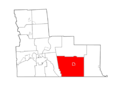
Map highlighting Windsor's location within Broome County.
|
|
| Country | United States |
| State | New York |
| County | Broome |
| Government | |
| • Type | Town Council |
| Area | |
| • Total | 93.01 sq mi (240.89 km2) |
| • Land | 91.75 sq mi (237.64 km2) |
| • Water | 1.25 sq mi (3.24 km2) |
| Elevation | 973 ft (297 m) |
| Population
(2020)
|
|
| • Total | 5,804 |
| • Estimate
(2016)
|
6,091 |
| • Density | 68.4/sq mi (26.4/km2) |
| Time zone | UTC−5 (Eastern (EST)) |
| • Summer (DST) | UTC−4 |
| ZIP Code |
13865
|
| FIPS code | 36-007-82535 |
| GNIS feature ID | 0979649 |
Windsor is a small town in Broome County, New York, United States. In 2020, about 5,804 people lived there.
The town is located on the southern edge of Broome County. It is east of the city of Binghamton. The village of Windsor is part of the town. It sits right on the Susquehanna River.
Contents
History of Windsor
This area along the Susquehanna River has a long history. Different groups of Native Americans lived here. They used the river for travel, water, and fishing.
Around 1712, some of the Tuscarora tribe settled in the northern part of the town. They were an Iroquoian-speaking group. They had moved from North Carolina to escape wars. In 1722, the Tuscarora joined the Iroquois Confederacy as the Sixth Nation.
Their strong village, Onaquaga, was an important outpost for the British. A mission was set up there by Sir William Johnson. Mohawk people and other British allies also lived there.
During the American Revolutionary War, Joseph Brant used Onaquaga as a base. His group, Brant's Volunteers, fought with the British. In October 1778, the Continental Army attacked and destroyed Onaquaga. This was in response to raids by the British and Iroquois.
New settlers came to the region in 1785. Many were "Yankees" from New England and war veterans. They officially formed the town of Windsor in 1807. This was one year after Broome County was created.
Later, parts of Windsor were used to create other towns. These included Sanford and Colesville in 1821. In 1851, a small piece of Windsor helped form the town of Conklin. For many years, farming was the main way people made a living here.
Geography of Windsor
Windsor is a town with a total area of about 93 square miles (240.9 square kilometers). Most of this area is land. About 1.36% of the town is water.
The southern border of the town is also the border with Pennsylvania. The Susquehanna River flows south through the town.
Major highways cross the town from east to west. These include New York State Route 17 and Interstate 86. New York State Route 79 runs north and south. It meets NY-17 in Windsor village.
Population and People
| Historical population | |||
|---|---|---|---|
| Census | Pop. | %± | |
| 1820 | 3,354 | — | |
| 1830 | 2,175 | −35.2% | |
| 1840 | 2,368 | 8.9% | |
| 1850 | 2,645 | 11.7% | |
| 1860 | 2,672 | 1.0% | |
| 1870 | 2,958 | 10.7% | |
| 1880 | 3,286 | 11.1% | |
| 1890 | 3,035 | −7.6% | |
| 1900 | 2,967 | −2.2% | |
| 1910 | 2,495 | −15.9% | |
| 1920 | 2,137 | −14.3% | |
| 1930 | 2,183 | 2.2% | |
| 1940 | 2,625 | 20.2% | |
| 1950 | 2,974 | 13.3% | |
| 1960 | 4,373 | 47.0% | |
| 1970 | 5,646 | 29.1% | |
| 1980 | 5,911 | 4.7% | |
| 1990 | 6,440 | 8.9% | |
| 2000 | 6,421 | −0.3% | |
| 2010 | 6,274 | −2.3% | |
| 2020 | 5,804 | −7.5% | |
| 2019 (est.) | 5,886 | −6.2% | |
| U.S. Decennial Census | |||
In 2000, there were 6,421 people living in Windsor. There were 2,339 households. About 37.2% of these households had children under 18.
The population was spread out by age. About 29.5% were under 18 years old. About 11.3% were 65 years or older. The average age in the town was 37 years.
Communities and Places in Windsor Town
The town of Windsor has several smaller communities and locations:
- Blatchley– A small community in the southwest.
- Cascade Valley – A community near the southern border.
- Damascus – A community southeast of Windsor village. You can reach it from Exit 80 of NY-17.
- Dunbar – A community in the northwest part of the town.
- East Windsor – A community northeast of Windsor village.
- Edson – A community south of Windsor village.
- Flowers – A community southwest of Windsor village.
- Hawkins Pond Park – A park located at the southern town line.
- Lester – A place in the western part of the town.
- Occanum – A community west of Windsor village. It is served by Exit 78 of NY-17.
- South Windsor – A community south of Windsor village on NY Route 79.
- State Line – A community near the Pennsylvania border on Route 79.
- Wake – A place near the eastern town line.
- West Windsor – A community near the western town line on NY-17. You can get there from NY-17's Exit 77.
- Windsor – This is the main village. It is by the Susquehanna River in the center of the town. You can reach it from Exit 79 of NY-17.
Notable People from Windsor
Many interesting people have connections to Windsor:
- Joel Bennett, a former professional baseball pitcher.
- Joseph Brant, an important Mohawk leader during the American Revolutionary War.
- Joseph H. Brownell, who was a member of the New York State Assembly.
- Jedediah M. Grant, a leader in the Church of Jesus Christ of Latter-day Saints.
- James Hard, believed to be the last Union soldier from the American Civil War to live.
- Giles W. Hotchkiss, a former member of the U.S. Congress.
- Ralph Hungerford, who was the 33rd Governor of American Samoa.
- Brian Weaver, a retired professional racing driver.
- Douglas H. Wheelock, a U.S. Army officer and NASA astronaut.
See also
 In Spanish: Windsor (pueblo) para niños
 | Delilah Pierce |
 | Gordon Parks |
 | Augusta Savage |
 | Charles Ethan Porter |


