
Terrain facts for kids
Terrain, also called relief, is how we describe the "up and down" shape of the Earth's surface. Think of it as the third dimension of the land, showing how high or low, flat or bumpy, a place is. When we talk about the shape of the land underwater, we use a special word: bathymetry.
Sometimes, you might hear the word topography used to mean terrain. While topography originally meant describing a place in general, it's now often used to talk about the land's shape.
Terrain is a key idea in physical geography. It describes the "lie of the land" and is usually explained by:
- Elevation: How high the land is above sea level.
- Slope: How steep the land is, like a hill or a mountain side.
- Orientation: The direction a slope faces, like north or south.
The shape of the land affects many things. For example, it changes how water flows across the surface and where it collects. Over large areas, terrain can even influence weather and climate patterns, like how mountains can block rain clouds.
Images for kids
-
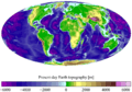
This map shows the present-day Earth's altimetry (land height) and bathymetry (ocean depth). The data comes from the National Geophysical Data Center.
-
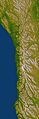
This image shows the varied terrain of New Zealand's Alpine Fault, which is about 500 km (300 mi) long. The image uses data from the Shuttle Radar Topography Mission to make the terrain look enhanced with shading and color. You can see a steep cliff (called an escarpment) next to a chain of hills, between the fault line and the mountains of New Zealand's Southern Alps. The top of the image points northeast.

See also
 In Spanish: Relieve terrestre para niños
