Geography of New York (state) facts for kids
 |
|
| Region | Northeast United States |
|---|---|
| Coordinates | 43°00′N 75°30′W / 43°N 75.5°W |
| Area | |
| • Total | 54,555 sq mi (141,300 km2) |
| • Land | 86.4% |
| • Water | 13.6% |
| Borders | Ontario Quebec Vermont Massachusetts Connecticut New Jersey Pennsylvania |
| Highest point | Mount Marcy, 5,343 feet (1,629 m) |
| Lowest point | Atlantic Ocean, sea level |
| Longest river | Hudson River |
| Largest lake | Lake Erie |
New York State has many different kinds of land. You'll find lots of farms, forests, rivers, mountains, and lakes here. The Adirondack Park in New York is huge! It's even bigger than any U.S. National Park in the main part of the country.
Niagara Falls is a famous spot. It's on the Niagara River, which flows from Lake Erie to Lake Ontario. The Hudson River starts way up north at Lake Tear of the Clouds. It flows south through eastern New York. It doesn't connect to Lake George or Lake Champlain. Lake George flows into Lake Champlain. Lake Champlain even reaches into Canada, where its water goes into the Richelieu River and then the St. Lawrence River.
Four of New York City's five main areas are on islands. These islands are at the mouth of the Hudson River. They are Manhattan Island, Staten Island, and Long Island (where Brooklyn and Queens are). "Upstate New York" is a common name for areas north of the New York City suburbs. This includes the Catskill Mountains, the Capital region, and the Adirondacks. The highest point in New York is Mount Marcy in the Adirondack Mountains. New York is the 27th largest state in the U.S.
Contents
Where is New York?
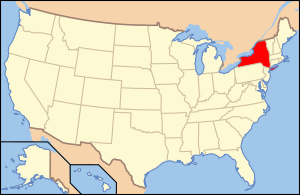
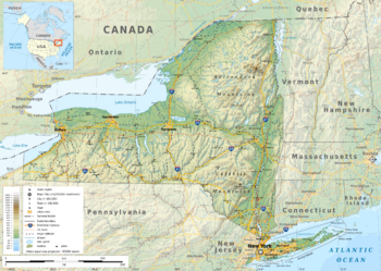
New York is located in the northeastern United States. It's part of the Mid-Atlantic region. The state covers about 54,556 square miles (141,299 km²). This makes it the 27th largest state overall.
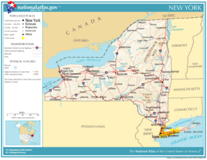
New York shares borders with six other U.S. states. These are Pennsylvania and New Jersey to the south. To the east are Connecticut, Rhode Island (across Long Island Sound), Massachusetts, and Vermont. New York also borders two Canadian provinces: Ontario and Quebec to the north. The state also touches the Atlantic Ocean to the southeast. Two of the Great Lakes are also on its borders: Lake Erie to the west and Lake Ontario to the northwest.
New York's Land Features
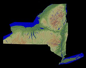
New York is part of the Appalachian Mountains. In New York, these mountains become more like hills. They eventually flatten out into lowlands around Lake Ontario and the St. Lawrence River.
There are three main mountain areas in the state.
- The first range comes from New Jersey. It goes through Rockland and Orange counties. It then crosses the Hudson River into Putnam and Dutchess counties. This range is called the Hudson Highlands. Its highest peaks are about 1,000 to 1,700 feet (300 to 520 m) high. These mountains are rough and rocky, not good for farming.
- The second mountain range comes from Pennsylvania. It goes through Sullivan, Ulster, and Greene counties. It ends in the Catskill Mountains west of the Hudson River. The highest peaks here are about 3,000 to 4,200 feet (910 to 1,280 m) high. The Shawangunk Mountains are part of this range. Much of this area is also too rough for farming.
- The third mountain area is in the northeast. These are the Adirondack Mountains. The Mohawk River separates this region from the southern highlands. The highest mountain in New York, Mount Marcy, is in the Adirondacks. It stands 5,344 feet (1,629 m) above sea level. This region is wild and rocky. It's not good for farming, but it has many minerals, especially iron ore.
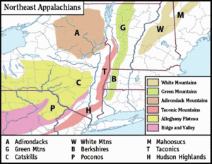
In western New York, hills from the Allegheny Mountains enter the state from Pennsylvania. These hills cover the southern part of western New York. The highest points in Allegany and Cattaraugus counties are about 2,000 to 2,500 feet (610 to 760 m) above sea level. Much of this area is too steep for farming.
North of these hills, the land slopes down towards Lake Ontario. It forms flat areas that look like steps. These areas are generally smooth and good for farming. Long Island is mostly flat or gently rolling. A ridge of sand, gravel, and clay runs across the island. It is about 150 to 200 feet (46 to 61 m) high.
New York's Climate
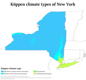
Most of Upstate New York has a humid continental climate. This means it has warm summers and cold winters. Downstate New York, closer to the coast, has a warmer humid subtropical climate.
In most of the state, winter temperatures are usually below freezing in January and February. But along the Atlantic coast, they are often above freezing. Summer-like weather happens statewide between June and September. In the south, summer conditions last longer, from May to October. Western New York often has more clouds because of the Great Lakes.
Rain and snow are spread fairly evenly throughout the year. Thunderstorms and snowstorms often move across the state. Lake-effect snow is common near the Great Lakes. Strong hurricanes or tornadoes are rare in New York.
Rivers and Lakes of New York
New York's rivers flow in two main directions. Some rivers flow north into the Great Lakes and the St. Lawrence River. Others flow south. A high ridge, called a watershed divide, separates these two systems.
The northern river system has five main parts:
- The westernmost part includes streams flowing into Lake Erie and the Niagara River. These streams are short and fast. Important ones are Cattaraugus, Buffalo, and Tonawanda creeks.
- The second part is the Genesee River and its branches. The Genesee starts in Pennsylvania and flows north to Lake Ontario. It has a deep gorge and forms Portage Falls. Near Rochester, it forms the Upper Genesee Falls.
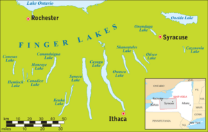
- The third part is the Oswego River system. This area has many inland lakes, which are a special part of New York's scenery. Many of these are the Finger Lakes, like Cayuga and Seneca. These lakes are long and narrow, filling deep valleys. Oneida and Onondaga lakes are also in this basin.
- The fourth part includes rivers flowing into Lake Ontario and the St. Lawrence River east of the Oswego. These include the Salmon, Black, and Raquette rivers. Their water is often dark from iron and plants.
- The fifth part includes streams flowing into Lakes George and Champlain. These are mostly fast mountain streams with waterfalls. The Chazy, Saranac, and Ausable rivers are examples.
The southern river system includes the Allegheny, Susquehanna, Delaware, and Hudson basins.
- The Allegheny River flows through parts of Chautauqua and Cattaraugus counties. It flows in a semicircle, with many branches from the north and east.
- The Susquehanna River starts in Otsego Lake. It flows southwest into Pennsylvania, then re-enters New York. It receives the Chenango River and Chemung River.
- The Delaware River basin covers Delaware and Sullivan counties. Its main branches are the Pepacton and Neversink rivers. These rivers flow through deep, narrow valleys.
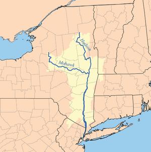
- The Hudson River basin covers a large part of eastern New York. The Hudson starts high in the Adirondacks, over 4,000 feet (1,200 m) above sea level. It flows quickly through narrow passes. Near Troy, the river becomes an estuary, meaning its flow is affected by ocean tides. South of Troy, the Hudson flows between high, rocky banks called The Palisades. The Mohawk River is a major branch of the Hudson.
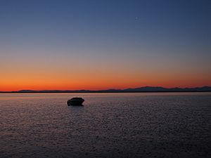
Lake Erie forms part of New York's western border. It is 240 miles (386 km) long and 38 miles (61 km) wide on average. It is 565 feet (172 m) above sea level. Harbors on Lake Erie include Buffalo and Dunkirk.
The Niagara River flows out of Lake Erie. It is 34 miles (55 km) long. About 20 miles (32 km) below Lake Erie, the famous Niagara Falls are found.
Lake Ontario forms part of New York's northern border. It is 130 miles (209 km) long and 55 miles (89 km) wide. It is 232 feet (71 m) above sea level. Harbors on Lake Ontario include Oswego and Sackets Harbor. The St. Lawrence River flows out of Lake Ontario. It forms the northern border of the state. In its upper part, it has many small islands called the Thousand Islands.
The water levels of the Great Lakes can change. This is due to winds, rain, and evaporation. Lake Erie's level can change by 7 feet (2 m), and Lake Ontario's by 4 feet (1 m).
New York State Parks
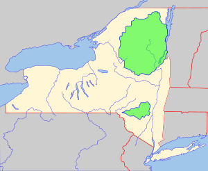
New York has many state parks and two large forest preserves. The Adirondack Park is huge, about the size of the state of Vermont. It was created in 1892 and protected by the state's constitution in 1894. The idea for the park came from a book called Man and Nature by George Perkins Marsh. He wrote about how cutting down too many trees could harm the land.
The Catskill Park was protected in 1885. Its land is meant to be kept safe and never sold. This park covers 700,000 acres (2,833 km²). It is home to animals like bobcats, minks, and fishers. About 400 black bears live in the region. The state runs many campgrounds and keeps over 300 miles (480 km) of trails for different uses.
 | Claudette Colvin |
 | Myrlie Evers-Williams |
 | Alberta Odell Jones |


