West Canada Creek facts for kids
Quick facts for kids West Canada Creek |
|
|---|---|

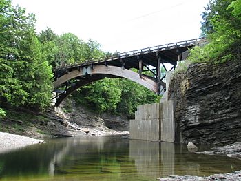
View of West Canada Creek in Prospect Gorge
|
|
|
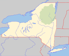
Location of the mouth of the West Canada Creek in New York State
|
|
| Country | United States |
| State | New York |
| Counties | Hamilton, Oneida, Herkimer |
| Physical characteristics | |
| Main source | West Lake, Mud Lake, South Lake Town of Arietta, Hamilton County 43°35′14″N 74°36′49″W / 43.58722°N 74.61361°W |
| River mouth | Mohawk River Village of Herkimer, Herkimer County 43°01′16″N 74°57′46″W / 43.02111°N 74.96278°W |
| Length | 76 mi (122 km) |
| Basin features | |
| Basin size | 565 sq mi (1,460 km2) |
| Tributaries |
|
| Waterfalls | Wilmurt Falls, Trenton Falls |
The West Canada Creek is a 76-mile-long (122 km) river in New York State, United States. This important waterway flows through Hamilton, Oneida, and Herkimer counties. It starts in the southern Adirondack Mountains and flows into the Mohawk River near the Village of Herkimer. The name "Canada" comes from an Iroquoian word, Kanata, which means "village."
Contents
Fun Activities on West Canada Creek
The West Canada Creek is a great place for outdoor fun. It has beautiful waterfalls in the Prospect Gorge, like Trenton Falls. These falls were once a very popular spot for tourists.
Today, people use the creek for many things. It helps make electricity for homes and businesses. It's also a favorite spot for trout fishing and tubing. There's even a special "trophy section" for fishing from Trenton Falls to the Oneida/Herkimer county border. Groups like the Trout Power Initiative work to make sure the creek's power generation doesn't harm the wild trout.
For hundreds of years, people have used the area's timber, fish, and game. Now, the entire West Canada Creek is protected by the New York State Wild, Scenic and Recreational Rivers System Act. This law helps keep the creek natural and beautiful for everyone.
History of the West Canada Creek
The West Canada Creek got its name for a few reasons. It was the western border of a large land grant given to Sir William Johnson, 1st Baronet. Also, the word Kanata, meaning "village," was used by the St. Lawrence Iroquoian people. Some believe the name "Canada" also refers to the creek being an important path to Canada long ago.
Native Americans also called the creek Te-ugh-ta-ra-row, which means "its waters are discolored." Because of its forest sources, the creek sometimes looked amber, giving it another old name, "Amber Creek."
The creek was also known as the Kuyahoora River. This name came from the Native American term Kuy-a-ho-ra, meaning "slanting waters" or "leaping waters." The valley around the river is still sometimes called the Kuyahoora Valley.
Logging and Lumber History
After the Revolutionary War, a man named Arthur Noble II bought a huge area of land, about 80,000 acres (320 km2), in what is now the town of Ohio. He named this area "Nobleboro." He built a saw mill there to cut down trees and send the wood to Ireland. In 1790, a road was built to Nobleboro, making it easier to transport goods.
Logging happened in Nobleboro before the Civil War. But in the late 1800s, there was a new demand for lumber and paper. This led to more activity in the forests. Pulp and paper mills were built in Hinkley, and sawmills were built in Nobleboro. The large forests to the north provided wood for these mills for many years.
Every spring, logs and pulpwood were floated down the creek on the melting snow. Nobleboro was a key spot for these "log drives." You can still see the foundation logs of the old dam that controlled the water flow. Log drives continued on the West Canada Creek until 1949. Since then, the land has recovered, and it's hard to tell that Nobleboro was once a busy industrial area.
Protecting the Wilderness
In the late 1800s and early 1900s, the area around the creek's source, the West Canada Lakes, was home to many woodsmen. These men were lumberjacks, trappers, fishermen, hunters, and guides. One famous character was Louis Seymore, also known as French Louie.
In 1922, the Adirondack Mountain Club was started. Its goal was to protect nature and keep trails in good condition. They created the Northville-Placid Trail, which goes through the West Canada Lakes area. The New York State Department of Environmental Conservation (NYSDEC) now maintains this trail.
By the 1930s, more and more anglers (people who fish) were flying into the West Canada Lakes. This caused the trout population to drop quickly. The state started adding trout to the lakes, but the fish numbers still went down. By the mid-1970s, the water became too acidic, harming trout in many lakes and parts of the river.
In 1972, the West Canada Lake Wilderness Area was created. This means no motorized vehicles or boats are allowed there. Scientists found that during spring snowmelt, a lot of acidic water entered the lakes and streams. This happened just when young trout were hatching. In the late 1980s, people started catching more brook trout and lake trout. Later studies showed that the water was less acidic, and trout populations were growing again.
In 1863, William H. Seward, who was Secretary of State for President Abraham Lincoln, met with leaders from other countries at Trenton Falls. He wanted to convince them not to support the Confederacy during the American Civil War.
Where the Creek Flows
The West Canada Creek flows through several interesting areas.
The West Canada Lakes
The West Canada Lakes are the starting point for the West Canada Creek. These lakes include West Lake, Mud Lake, and South Lake. Nearby Brook Trout Lake and Northrup Lake are the sources of the Indian River.
South Branch of the Creek
The south branch of the West Canada Creek begins at T-lake, which is northwest of Piseco Lake. It flows southwest through the town of Morehouse. Then, it joins the main part of the West Canada Creek at Nobleboro. North of Route 8, on Mountain Home Road, there's a man-made lake called The Floe on maps, but locals call it Mountain Home Pond.
Nobleboro
Nobleboro is where the north and south branches of the West Canada Creek meet. The land that drains into the creek here covers about 240 square miles (620 km2) of the southwestern Adirondack Park. This area is full of natural resources. The West Canada Lakes Wilderness Area now includes Fort Noble Mountain. This mountain had a fire tower from 1916 until 1985. A sign by the creek at Nobleboro spells it "Nobleborough," but most maps and books use "Nobleboro."
Wilmurt Falls and Ohio Gorge
Wilmurt Falls is downstream from Nobleboro in the town of Ohio. This waterfall is special because it separates different types of trout. Upstream from the falls, you'll find brook trout. Downstream, you'll mostly find brown and rainbow trout. The falls also mark the beginning of the Ohio gorge.
Hinckley Reservoir
Hinckley Reservoir is a man-made lake on the West Canada Creek. It's just upstream from the Prospect Gorge. A large dam holds back the water, built with a lot of concrete and dirt. The dam was finished in 1911 and took 500 workers four years to build. In 1928, campers wanted the reservoir's name changed to Kuyahoora Lake. However, the United States Board on Geographic Names still officially calls it "Hinckley Reservoir." The water from Hinckley Reservoir is used for drinking water in Utica. It also helps control the water level in the Barge Canal.
Prospect Gorge
The Prospect Gorge in the town of Trenton is not open to the public. It is owned by Brookfield Asset Management, which manages power generation on the creek. Access is limited because water is released from the dam at different times. This can cause the water levels to rise quickly and be dangerous. Before the late 1970s, the rules were not as strict, and water releases were more predictable.
Herkimer
By the time the West Canada Creek reaches the Mohawk River near the Village of Herkimer, it has drained a large area of land, about 569 square miles (1,470 km2).
Tributaries
Tributaries are smaller streams or rivers that flow into a larger river. The West Canada Creek has many tributaries.
Right Side Tributaries
- Honnedaga Brook
- Seabury Brook
- Big Brook
- Mill Creek
- Mad Tom Brook
- Concklin Brook
- Cincinnati Creek
- Shed Brook
- Mill Brook
Left Side Tributaries
- Indian River
- Metcalf Brook
- Betty Green Brook
- South Branch West Canada Creek
- Fourmile Brook
- Mill Creek
- Cold Brook
- Oklahoma Creek
- White Creek
- City Brook
- Maltanner Creek
- Stony Creek
- North Creek
How We Measure the Creek
The United States Geological Survey (USGS) has special tools called stream gauges along the West Canada Creek. These tools measure how much water is flowing.
One gauge has been working since October 1920. It's located about 2.2 miles (3.5 km) north of Herkimer, 4 miles (6.4 km) upstream from where the creek meets the Mohawk River. The most water it ever measured was 25,300 cubic feet (720 m3) per second on June 28, 2013. The least it measured was 20 cubic feet (0.57 m3) per second on September 3, 1929.
Another gauge started working in April 2001. It's about 2.6 miles (4.2 km) southwest of Wilmurt and 3 miles (4.8 km) upstream from Hinckley Reservoir. This gauge measured its highest flow on April 28, 2011, at 25,500 cubic feet (720 m3) per second. Its lowest flow was 34 cubic feet (0.96 m3) per second on September 14, 2002. There used to be another gauge near Nobleboro that took measurements from 1945 to 2000.
 | Charles R. Drew |
 | Benjamin Banneker |
 | Jane C. Wright |
 | Roger Arliner Young |


