Herkimer, New York facts for kids
Quick facts for kids
Herkimer, New York
|
|
|---|---|

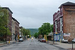
North Main Street
|
|

Location of Herkimer within Herkimer County
|
|
| Country | United States |
| State | New York |
| County | Herkimer |
| Area | |
| • Total | 32.23 sq mi (83.47 km2) |
| • Land | 31.66 sq mi (82.00 km2) |
| • Water | 0.57 sq mi (1.47 km2) |
| Population
(2020)
|
|
| • Total | 9,566 |
| Time zone | EST |
| • Summer (DST) | EDT |
| ZIP code |
13350
|
| Area code(s) | 315 |
| FIPS code | 36-043-34132 |
Herkimer is a town located in Herkimer County, New York, in the United States. It is found southeast of Utica. The town gets its name from Nicholas Herkimer, an important historical figure.
In 2020, about 9,566 people lived in Herkimer. This number was a bit lower than the 10,175 people counted in 2010. The town of Herkimer also contains a smaller area called the village of Herkimer. You can find Herkimer County Community College in this village.
Contents
History of Herkimer
The area known as Herkimer was first settled around 1722. Back then, it was called "Stone Ridge." Many of the first people to settle here were German Palatines.
A farmer named Johan Jost Herchheimer moved to the area in 1725. He was involved in trade and transportation along the Mohawk River. He settled on the south side of the river. His oldest son, Nicholas Herkimer, later started a farm on a large piece of land his father owned. This land included an important path around Little Falls on the Mohawk River.
In 1788, the town of Herkimer was officially created. It was named in honor of Nicholas Herkimer.
Herkimer During the French and Indian War
During the French and Indian War, the Mohawk Valley faced many attacks from the French and their Native American allies. By 1770, Nicholas Herkimer had become very wealthy from farming and trading during these wars. He also gained military experience as a captain in the local militia. He later became a general and fought in the famous Battle of Oriskany.
The Herkimer County shootings happened partly in Herkimer on March 13, 2013.
Geography of Herkimer
Herkimer is a town with a total area of about 83.5 square kilometers (32.23 square miles). Most of this area, about 82.0 square kilometers (31.66 square miles), is land. The remaining 1.5 square kilometers (0.57 square miles) is water.
The West Canada Creek flows into the Mohawk River near the village of Herkimer. On the other side of the Mohawk River, you can find the villages of Mohawk and Ilion.
Major roads like the New York State Thruway and New York State Route 5 pass through the southwestern part of the town. New York State Route 28 is another important highway that runs north and south, crossing NY-5 in Herkimer village.
Population of Herkimer
The population of Herkimer has changed over the years. Here's how it has grown and shrunk:
| Historical population | |||
|---|---|---|---|
| Census | Pop. | %± | |
| 1820 | 3,055 | — | |
| 1830 | 2,486 | −18.6% | |
| 1840 | 2,369 | −4.7% | |
| 1850 | 2,601 | 9.8% | |
| 1860 | 2,804 | 7.8% | |
| 1870 | 2,949 | 5.2% | |
| 1880 | 3,593 | 21.8% | |
| 1890 | 4,666 | 29.9% | |
| 1900 | 6,748 | 44.6% | |
| 1910 | 8,797 | 30.4% | |
| 1920 | 11,982 | 36.2% | |
| 1930 | 12,327 | 2.9% | |
| 1940 | 11,345 | −8.0% | |
| 1950 | 11,235 | −1.0% | |
| 1960 | 11,568 | 3.0% | |
| 1970 | 11,451 | −1.0% | |
| 1980 | 11,027 | −3.7% | |
| 1990 | 10,401 | −5.7% | |
| 2000 | 9,961 | −4.2% | |
| 2010 | 10,175 | 2.1% | |
| 2020 | 9,566 | −6.0% | |
| U.S. Decennial Census | |||
As of the year 2000, there were about 9,962 people living in the town. There were 4,114 households, which are groups of people living together in one home. The average household had about 2.29 people.
The population was spread out by age. About 20.2% of the people were under 18 years old. The median age, which is the middle age of all the people, was 40 years old.
Communities and Locations in the Town of Herkimer
- Beacon Light Corners – A place found near the western edge of the town.
- East Herkimer – A small village located east of Herkimer village on NY-5.
- Eatonville – A small village near the northeastern corner of the town.
- Hasenclever Hill – A hill located north of Herkimer.
- Herkimer – This is the main village within the town, located near the southern town line on NY-5 by the Mohawk River.
- Kast Bridge – A small village north of Herkimer village on NY-28.
- Mirror Lake – A small lake found north of Herkimer village.
- Oak Hill – A hill located northwest of Herkimer. Part of it is also in the Town of Schuyler.
- Osborne Hill – Another hill located northwest of Herkimer, also partly in the Town of Schuyler.
- Schrader Hill – A hill located north of Herkimer; part of it is in the Town of Newport.
- Steuben Hill – A hill located northwest of Herkimer.
See also
 In Spanish: Herkimer (Nueva York) para niños


