
Nowadaga Creek facts for kids
Quick facts for kids Nowadaga Creek |
|
|---|---|
| Country | United States |
| State | New York |
| Region | Central New York Region |
| Physical characteristics | |
| Main source | Ohisa Creek Newville, New York 558 ft (170 m) |
| River mouth | Mohawk River Indian Castle, New York 324 ft (99 m) 43°00′35″N 74°46′27″W / 43.00972°N 74.77417°W |
| Basin features | |
| Basin size | 31.4 sq mi (81 km2) |
Nowadaga Creek is a stream in New York. It flows through parts of towns like Danube, Stark, and Little Falls. It also goes through a small part of Warren. All these areas are in southern Herkimer County. Finally, the creek joins the Mohawk River in a place called Indian Castle, New York.
The area that Nowadaga Creek drains, called its drainage basin, is about 49 percent covered by forests. The creek is 10.0 miles long. It has an average slope of 1.7 percent, which means it goes downhill slightly as it flows. On an old map from 1790, the creek's name was spelled "Inchanando Creek."
How Nowadaga Creek Was Formed
Nowadaga Creek flows mostly over solid rock, called bedrock. This means the creek's path is shaped by the hard rock underneath it. Unlike many other creeks of its size, it doesn't have a wide, flat area next to it called a floodplain. A floodplain is usually formed by a river depositing soil over time.
In many places along the creek, the bedrock is breaking apart. Pieces of stone from the creek bed are carried downstream by the water. These stones can pile up in slower parts of the creek. When they do, they can cause blockages or make the water change its path. This can sometimes lead to flooding in nearby areas.
Images for kids
-
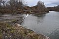
Mouth of Nowadaga Creek at Erie Canal

