Warren, New York facts for kids
Quick facts for kids
Warren, New York
|
|
|---|---|

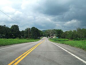
The small community of Warren along US 20
|
|

Where Warren is located in Herkimer County
|
|
| Country | United States |
| State | New York |
| County | Herkimer |
| Government | |
| • Type | Town Council |
| Area | |
| • Total | 38.37 sq mi (99.38 km2) |
| • Land | 38.05 sq mi (98.55 km2) |
| • Water | 0.32 sq mi (0.83 km2) |
| Elevation | 1,457 ft (444 m) |
| Population
(2010)
|
|
| • Total | 1,143 |
| • Estimate
(2016)
|
1,106 |
| • Density | 29.07/sq mi (11.22/km2) |
| Time zone | UTC-5 (Eastern (EST)) |
| • Summer (DST) | UTC-4 (EDT) |
| FIPS code | 36-043-78278 |
| GNIS feature ID | 0979597 |
There is also a Warren County, and a hamlet of Warren.
Warren is a small town located in Herkimer County, New York, in the United States. In 2010, about 1,143 people lived there. The town is named after General Joseph Warren, a hero who fought in the Battle of Bunker Hill. Warren is in the southern part of Herkimer County. A main road, US 20, goes right through the town.
History of Warren
People first started settling in the Warren area before 1776. The town of Warren was officially created in 1796. It was formed from a larger area that was once part of the town of German Flatts. Later, in 1812, a part of Warren was used to create a new town called Columbia.
In 2007, a special place called Sunset Hill was added to the National Register of Historic Places. This means it is an important historical site.
Geography of Warren
The town of Warren covers about 98.7 square kilometers (about 38.1 square miles). Most of this area is land, with only a small part (about 0.8 square kilometers or 0.3 square miles) being water.
Warren is located northeast of Canadarago Lake and the town of Richfield Springs. The southern and eastern edges of the town are also the border of Otsego County.
Population Changes
| Historical population | |||
|---|---|---|---|
| Census | Pop. | %± | |
| 1820 | 2,015 | — | |
| 1830 | 2,084 | 3.4% | |
| 1840 | 2,003 | −3.9% | |
| 1850 | 1,756 | −12.3% | |
| 1860 | 1,812 | 3.2% | |
| 1870 | 1,503 | −17.1% | |
| 1880 | 1,430 | −4.9% | |
| 1890 | 1,339 | −6.4% | |
| 1900 | 1,240 | −7.4% | |
| 1910 | 1,071 | −13.6% | |
| 1920 | 959 | −10.5% | |
| 1930 | 974 | 1.6% | |
| 1940 | 873 | −10.4% | |
| 1950 | 956 | 9.5% | |
| 1960 | 918 | −4.0% | |
| 1970 | 978 | 6.5% | |
| 1980 | 1,065 | 8.9% | |
| 1990 | 1,077 | 1.1% | |
| 2000 | 1,133 | 5.2% | |
| 2010 | 1,143 | 0.9% | |
| 2016 (est.) | 1,106 | −3.2% | |
| U.S. Decennial Census | |||
In 2000, there were 1,136 people living in Warren. There were 390 households, which are groups of people living together. About 32.3% of these households had children under 18 living with them.
The average age of people in Warren was 39 years old. About 23% of the population was under 18.
Places in Warren
Here are some of the communities and interesting spots you can find in the town of Warren:
- Crains Corners – This is a small area located east of Jordanville.
- Cullen – You can find Cullen south of Jordanville. The Church of the Good Shepherd here is a historic building.
- Harter Hill – This is a raised area, or hill, located north of Jordanville.
- Holy Trinity Monastery – This is a Russian Orthodox monastery located near Jordanville.
- Jordanville – This small community is in the northwestern part of the town.
- Kingdom – A small community right on the town line, northwest of Jordanville. Part of it is also in the town of Columbia.
- Maumee Swamp – A swampy area located north of Weaver Lake.
- Merry Hill – Another elevated area, located northeast of the main community of Warren.
- Mud Lake – A small lake found southeast of Crains Corners.
- Murray Hill – An elevated area located north of Crains Corners.
- Warren – This is the main community, or hamlet, of Warren. It's in the southeastern part of the town along Route 20. It used to be called "Little Lakes."
- Weatherby Pond – A pond located west-northwest of the hamlet of Warren.
- Weaver Lake – A small lake found northwest of the main Warren community.
- Young Lake – A small lake located south of the Warren community.
See also
 In Spanish: Warren (Nueva York) para niños
 | Chris Smalls |
 | Fred Hampton |
 | Ralph Abernathy |


