Canajoharie (village), New York facts for kids
Quick facts for kids
Canajoharie, New York
|
|
|---|---|

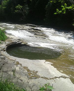
The "pot that washes itself" located just south of the Village of Canajoharie on the Canajoharie Creek
|
|
| Country | United States |
| State | New York |
| County | Montgomery |
| Town | Canajoharie |
| Government | |
| • Type | Mayor-Council government |
| Area | |
| • Total | 1.40 sq mi (3.62 km2) |
| • Land | 1.33 sq mi (3.45 km2) |
| • Water | 0.07 sq mi (0.18 km2) |
| Elevation | 305 ft (93 m) |
| Population
(2020)
|
|
| • Total | 2,037 |
| • Density | 1,530.43/sq mi (590.99/km2) |
| Demonym(s) | Canajoharian |
| Time zone | UTC-5 (Eastern (EST)) |
| • Summer (DST) | UTC-4 (EDT) |
| ZIP code |
13317
|
| Area code(s) | 518 |
| FIPS code | 36-12111 |
| GNIS feature ID | 0945734 |
Canajoharie (/ˌkænədʒəˈhɛəri/) is a small village in Montgomery County, New York. In 2010, about 2,229 people lived there.
The name "Canajoharie" comes from the Mohawk language. It means "the pot that washes itself." This name refers to a cool, round gorge in the Canajoharie Creek nearby.
Canajoharie village is located on the north side of the Town of Canajoharie. It is west of Amsterdam and east of Utica. The village and town names also refer to an older Mohawk town. This historic town was known as the "Upper Castle" by early English settlers. Today, a church from before the American Revolution stands there. This area is now a National Historic Landmark.
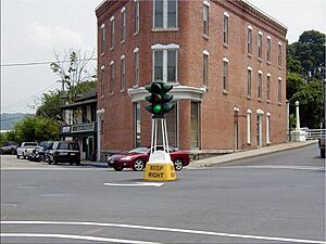
The village of Canajoharie used to have a special "dummy light" downtown. This was a traffic signal on a pole in the middle of an intersection. It was first put in place in 1926. However, due to safety concerns, the dummy light was removed in 2021. There are only two other such lights left in New York State.
The famous Erie Canal runs along the north side of the village.
Canajoharie was once the main place for making Beech-Nut baby food. The company started here in 1891. The factory closed in 2011, and production moved to another town nearby.
In 2015, most of the village became a historic district. This means its old buildings and importance as a transportation hub are protected. Several other buildings in Canajoharie are also listed individually as historic places. These include the Bragdon-Lipe House, the Van Alstyne Homestead, the West Hill School, and the United States Post Office.
Contents
History of Canajoharie

Early Mohawk Settlement
The village we know today is east of the original historic Canajoharie. This was one of the two main towns of the Mohawk nation in the 1600s and 1700s. The Mohawk Upper Castle Historic District is in this older area. It includes the Upper Castle Church from 1769 and old sites from Mohawk history. It is a very important National Historic Landmark.
German Settlers Arrive
In the 1730s, German settlers came to this area. They were Protestants who had fled religious wars in Europe. The British government helped them come to America. Their community was first called "Roofville." This name came from an early settler named Johannes Rueff. The village officially became a village in 1829.
Fires and Rebuilding
In the mid-1800s, three big fires nearly destroyed the village. Because of these fires, the village made a rule. New houses could not be built from wood. This is why many older homes in Canajoharie are made of brick or local stone. After the fires, the village was renamed Canajoharie.
George Washington's Visit
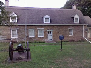
After the Revolutionary War, George Washington visited Canajoharie. He was checking on damage in nearby Cherry Valley. This area had been attacked by Joseph Brant, a Mohawk chief who sided with the British. Washington stayed overnight at the Van Alstyne Homestead. This house was a common meeting place back then.
Geography and Location
Canajoharie village covers about 1.3 square miles (3.4 square kilometers). Most of this area is land, with a small part being water.
The village is located on the south bank of the Mohawk River.
Several important roads pass through Canajoharie. These include the New York State Thruway, New York State Route 5S, and New York State Route 10. On the other side of the Mohawk River is Palatine Bridge. Both names refer to the early German settlers.
Wintergreen Park is a beautiful spot about a mile from downtown. It offers great views of the Canajoharie Gorge and the Canajoharie Falls.
Population Information
| Historical population | |||
|---|---|---|---|
| Census | Pop. | %± | |
| 1840 | 1,146 | — | |
| 1850 | 2,000 | 74.5% | |
| 1860 | 1,500 | −25.0% | |
| 1870 | 1,822 | 21.5% | |
| 1880 | 2,013 | 10.5% | |
| 1890 | 2,089 | 3.8% | |
| 1900 | 2,101 | 0.6% | |
| 1910 | 2,273 | 8.2% | |
| 1920 | 2,415 | 6.2% | |
| 1930 | 2,519 | 4.3% | |
| 1940 | 2,577 | 2.3% | |
| 1950 | 2,761 | 7.1% | |
| 1960 | 2,681 | −2.9% | |
| 1970 | 2,686 | 0.2% | |
| 1980 | 2,412 | −10.2% | |
| 1990 | 2,278 | −5.6% | |
| 2000 | 2,257 | −0.9% | |
| 2010 | 2,229 | −1.2% | |
| 2020 | 2,037 | −8.6% | |
| U.S. Decennial Census | |||
In 2010, Canajoharie had 2,229 people living there. The village had 929 households. About 30.9% of these households had children under 18. The average household had 2.37 people.
The population was spread out by age. About 27.5% were under 18. The median age was 38 years old. Most of the people living in the village were White (95%).
Famous People from Canajoharie
Many interesting people have connections to Canajoharie:
- Susan B. Anthony: A famous leader for women's rights. She taught school here.
- Joseph Brant: A well-known Mohawk chief.
- Molly Brant: Another important Mohawk leader.
- Chad Michael Collins: An actor.
- Alfred Conkling: A lawyer and judge.
- Frederick Conkling: Son of Alfred Conkling, who became a US Representative for New York.
- Josiah Failing: The fourth mayor of Portland, Oregon. He was a successful business owner.
- Bernhard Gillam: A political cartoonist. He passed away in Canajoharie.
- Myron Grimshaw: A major league baseball player. He played for the Boston Red Sox.
- Thomas James: A former slave who became a minister. He wrote a famous memoir.
- Jacob Klock: A colonel during the American Revolutionary War.
- Sean MacFarland: A high-ranking US Army General.
- Charles McVean: A US Representative for New York. He edited the town's newspaper.
- Ots-Toch: A 17th-century Mohawk woman. She married a Dutch trader and started the Van Slyck family.
- Edwin M. Randall: A Chief Justice for the state of Florida.
- Hendrick Theyanoguin: A Mohawk leader.
- Benjamin Van Alstyne: A head coach for the Michigan State University basketball team.
- Rebecca Winters: A Mormon pioneer.
See also
 In Spanish: Canajoharie (villa) para niños
 | Bayard Rustin |
 | Jeannette Carter |
 | Jeremiah A. Brown |


