Canajoharie, New York facts for kids
Canajoharie (pronounced like "can-a-juh-HAIR-ee") is a town in Montgomery County, New York, United States. In 2010, about 3,730 people lived here. Canajoharie is located south of the Mohawk River, which forms the northern border of the county. The Erie Canal also runs along the town's northern edge. There is also a village called Canajoharie within the town. Both the town and village are east of Utica and west of Amsterdam.
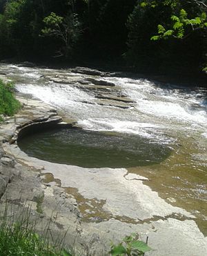
The name "Canajoharie" comes from the Mohawk language. It means "the pot that washes itself." This refers to a special pothole or natural basin in the Canajoharie Creek. This area was once an important village for the Mohawk Nation, also known as their Upper Castle.
Quick facts for kids
Canajoharie, New York
|
|
|---|---|

The "pot that washes itself", also known as Foley’s Water Spout is a pothole located just south of the Village of Canajoharie on the Canajoharie Creek
|
|

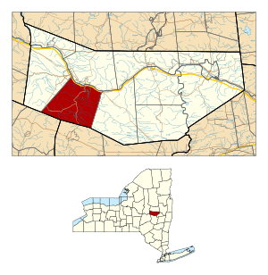
Location within Montgomery County and the state of New York.
|
|
| Country | United States |
| State | New York |
| County | Montgomery |
| Government | |
| • Type | Town Council |
| Area | |
| • Total | 43.10 sq mi (111.63 km2) |
| • Land | 42.60 sq mi (110.34 km2) |
| • Water | 0.50 sq mi (1.29 km2) |
| Population
(2010)
|
|
| • Total | 3,730 |
| • Estimate
(2016)
|
3,613 |
| • Density | 84.81/sq mi (32.74/km2) |
| Time zone | UTC-5 (Eastern (EST)) |
| • Summer (DST) | UTC-4 (EDT) |
| FIPS code | 36-057-12122 |
Contents
A Look Back: Canajoharie's Story
The town of Canajoharie is located near an old village of the Mohawk nation. This village was very important to the Mohawk people. Their territory covered much of central New York. They traded furs with French, Dutch, and English settlers.
European settlers began moving into the area around 1737. The Mohawk people slowly started to adopt some English ways. During the American Revolutionary War, the Mohawk and other Iroquois nations were allies with the British. After the United States won the war, the Mohawk had to give up most of their lands in New York.
Canajoharie town was damaged by fire two times. Because of this, a rule was made that new homes could not be built from wood. This is why many older homes in the town are made of brick or stone.
After the Revolutionary War, George Washington visited Canajoharie. He stayed at the Van Alstyne home, which was a common meeting place.
The modern town of Canajoharie was officially formed in 1788. Later, parts of it were used to create the towns of Minden (in 1797) and Root (in 1822). The Erie Canal helped the area grow. In 1865, the town had 4,248 people.
Beech-Nut, a company that makes baby food, started in Canajoharie in 1890. For over 100 years, it was the biggest employer in the town. In 2011, the Beech-Nut factory moved to a new location in the nearby town of Florida.
Famous Faces from Canajoharie
Many interesting people have connections to Canajoharie:
- Susan B. Anthony: A famous pioneer for women's rights, she taught school here.
- Joseph Brant: An important chief of the Mohawk nation.
- Molly Brant: A respected leader of the Mohawk nation.
- Chad Michael Collins: An actor born in 1979.
- Alfred Conkling: A lawyer and statesman.
- Myron Grimshaw: A Major League Baseball player for the Boston Red Sox.
- Thomas James: A former slave who became a minister.
- Mary Anne Krupsak: A lawyer and politician who was Lieutenant Governor of New York.
- Sean MacFarland: A Lieutenant General in the United States Army.
- George A. Mitchell: The person who founded Cadillac, Michigan.
- Ots-Toch: A 17th-century Mohawk woman who married a Dutch trader.
- Hendrick Theyanoguin: A significant Mohawk leader.
Where is Canajoharie?
The United States Census Bureau says that Canajoharie has a total area of about 43.10 square miles (111.63 square kilometers). Most of this is land, and a small part is water.
The southern border of the town is also the border of Schoharie County. The northern border of the town is the Mohawk River.
The New York State Thruway (a major highway) runs through the northern part of the town, following the river. New York State Route 5S runs parallel to the Thruway. New York State Route 10 is a highway that goes north and south. It crosses the Thruway and NY-5S near Canajoharie village.
Exploring Canajoharie's Neighborhoods
Here are some of the communities and places you can find in the town of Canajoharie:
- Ames: A village in the southern part of the town, located on NY-10.
- Bowmans Creek: A stream that flows through the southern part of the town.
- Budd Hill: A spot near the southern town line, south of Ames.
- Buel: A small community (called a hamlet) in the southwestern part of the town, along Bowmans Creek. This area was once known as Bowmans Creek.
- Canajoharie: The main village in the northern part of the town, by the Mohawk River and NY-10.
- Canajoharie Creek: A stream in the south-central part of the town.
- Canajoharie Falls: A beautiful waterfall located south of the Village of Canajoharie.
- Fort Plain: A village that is partly located within Canajoharie town, at the western town line.
- Maple Hill: A place east of Marshville.
- Mapletown: A location near the eastern town line, named after the maple trees there.
- Marshville: A hamlet south of Canajoharie village on NY-10.
- Sprout Brook: A hamlet in the southwestern part of the town, also on Bowmans Creek.
- Van Deusenville: A hamlet near the town line in the southwestern section of the town.
- Waterville: A hamlet northeast of Ames.
Population Facts
The population of Canajoharie has changed over the years:
| Historical population | |||
|---|---|---|---|
| Census | Pop. | %± | |
| 1820 | 4,677 | — | |
| 1830 | 4,348 | −7.0% | |
| 1840 | 5,146 | 18.4% | |
| 1850 | 4,097 | −20.4% | |
| 1860 | 4,134 | 0.9% | |
| 1870 | 4,256 | 3.0% | |
| 1880 | 4,294 | 0.9% | |
| 1890 | 4,267 | −0.6% | |
| 1900 | 3,838 | −10.1% | |
| 1910 | 3,889 | 1.3% | |
| 1920 | 3,784 | −2.7% | |
| 1930 | 4,023 | 6.3% | |
| 1940 | 4,062 | 1.0% | |
| 1950 | 4,294 | 5.7% | |
| 1960 | 4,233 | −1.4% | |
| 1970 | 4,319 | 2.0% | |
| 1980 | 4,140 | −4.1% | |
| 1990 | 3,909 | −5.6% | |
| 2000 | 3,797 | −2.9% | |
| 2010 | 3,730 | −1.8% | |
| 2016 (est.) | 3,613 | −3.1% | |
| U.S. Decennial Census | |||
In 2000, there were 3,797 people living in the town. About 33.2% of households had children under 18. The average household had 2.52 people. The median age in the town was 39 years old.
See also
 In Spanish: Canajoharie para niños
 | Leon Lynch |
 | Milton P. Webster |
 | Ferdinand Smith |

