Root, New York facts for kids
Quick facts for kids
Root, New York
|
|
|---|---|

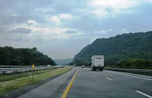
Little Nose Hill as seen from I-90/NY Thruway
|
|

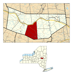
Location in Montgomery County and the state of New York.
|
|
| Country | United States |
| State | New York |
| County | Montgomery |
| Government | |
| • Type | Town Council |
| Area | |
| • Total | 51.08 sq mi (132.29 km2) |
| • Land | 50.65 sq mi (131.19 km2) |
| • Water | 0.43 sq mi (1.10 km2) |
| Elevation | 863 ft (263 m) |
| Population
(2010)
|
|
| • Total | 1,715 |
| • Estimate
(2016)
|
1,676 |
| • Density | 33.09/sq mi (12.78/km2) |
| Time zone | UTC-5 (Eastern (EST)) |
| • Summer (DST) | UTC-4 (EDT) |
| ZIP code |
12166
|
| Area code(s) | 518 |
| FIPS code | 36-63561 |
| GNIS feature ID | 0979432 |
Root is a town located in Montgomery County, New York, United States. In 2010, about 1,715 people lived there. The town was named after Erastus Root, who was an important lawmaker a long time ago.
The Town of Root is in the south-central part of Montgomery County. It is located southwest of the city of Amsterdam. The famous Erie Canal runs along the northern edge of Root.
Contents
History of Root
The land that is now the Town of Root was part of a large area of about 25,000 acres. This land was given to William Corry, George Clark, and others in 1737. The first British settlers arrived near Currytown before the American Revolution. This area was considered a frontier, meaning it was at the edge of settled lands.
During the American Revolution, the small community was attacked and burned. This attack was carried out by Iroquois allies of the British, led by Captain John Doxtader.
Root was once part of a larger area called the "Town of Mohawk." In 1823, Root was officially created from a part of the Town of Charleston. After the Revolutionary War, many people from New England moved to this area. They were looking for land. For many years, the culture of Root was very similar to that of the New England settlers.
Geography of Root
The United States Census Bureau says that Root covers a total area of about 51 square miles (132 square kilometers). Most of this area, about 50.8 square miles (131.6 square kilometers), is land. Only a small part, about 0.2 square miles (0.5 square kilometers), is water.
The northern border of the town is formed by the Mohawk River. The southern border of Root touches Schoharie County.
In the 1900s, the New York State Thruway was built through the northern part of the town. This highway follows the path of the Mohawk River. New York State Route 5S also runs along the Mohawk River. It meets New York State Route 162 at a place called Sprakers. Sprakers is in the northwestern part of Root.
People of Root
| Historical population | |||
|---|---|---|---|
| Census | Pop. | %± | |
| 1830 | 2,750 | — | |
| 1840 | 2,979 | 8.3% | |
| 1850 | 2,736 | −8.2% | |
| 1860 | 2,622 | −4.2% | |
| 1870 | 2,492 | −5.0% | |
| 1880 | 2,275 | −8.7% | |
| 1890 | 2,041 | −10.3% | |
| 1900 | 1,653 | −19.0% | |
| 1910 | 1,512 | −8.5% | |
| 1920 | 1,198 | −20.8% | |
| 1930 | 1,021 | −14.8% | |
| 1940 | 1,106 | 8.3% | |
| 1950 | 1,214 | 9.8% | |
| 1960 | 1,243 | 2.4% | |
| 1970 | 1,513 | 21.7% | |
| 1980 | 1,801 | 19.0% | |
| 1990 | 1,692 | −6.1% | |
| 2000 | 1,752 | 3.5% | |
| 2010 | 1,715 | −2.1% | |
| 2016 (est.) | 1,676 | −2.3% | |
| U.S. Decennial Census | |||
Based on the census from 2000, there were 1,752 people living in Root. These people lived in 656 households, and 492 of these were families. The population density was about 34.5 people per square mile.
About 33.4% of households had children under 18 living with them. Most households, 62.0%, were married couples living together. About 19.7% of all households were made up of single individuals.
The average age of people in Root was 40 years old. About 26.7% of the population was under 18. About 13.6% of the population was 65 years or older. For every 100 females, there were about 100.9 males.
The average income for a household in Root was $38,060. For families, the average income was $41,927. About 11.8% of the total population lived below the poverty line. This included 17.3% of those under 18.
Communities and Places in Root
Root has several small communities and interesting places:
- Browns Hollow – A small village, or hamlet, located southwest of Root Center.
- Buttermilk Falls – A beautiful waterfall found northeast of Currytown.
- Currytown – A hamlet located on NY-162 near the middle of Root. Its name comes from "Corry's patent," the original land grant.
- Flat Creek – A place southwest of Currytown. It is located on a creek also named Flat Creek. The town's government offices are here.
- Flat Creek – This is a stream that flows north through the western part of Root. It eventually joins the Mohawk River.
- Kilmartin Corners – A location near the southern border of the town.
- Little Nose – A natural landmark near the Mohawk River. Along with Big Nose on the other side of the river, it forms a spot called "The Noses." This is where the Erie Canal was built through the Appalachian Mountains.
- Lykers (also known as "Lykers Corners") – A location south of Root Center.
- Randall – A hamlet in the northeastern part of Root, located on NY-5S.
- Root Center – A hamlet found south of Currytown.
- Rural Grove – A hamlet southeast of Currytown, also on NY-162.
- Sprakers (once called "Sprakers Basin") – A hamlet located by the Erie Canal and Mohawk River. It's where NY-5S and NY-162 meet in the northeastern part of Root.
- Stone Ridge – A hamlet on the town line in the northeastern corner of the town, along NY-5S.
- Sutphens Hollow – A former community in the northwestern part of Root, near Flat Creek. It used to be called "Hamilton Hollow."
- Yatesville – A former community that was located by the Mohawk River.
Famous People from Root
- Stewart Friesen, a professional race car driver.
- Annabel Morris Holvey (1855–1910), who was a newspaper editor and worked for social change.
- George A. Mitchell, who founded the city of Cadillac, Michigan.
See also
 In Spanish: Root (Nueva York) para niños
 | Isaac Myers |
 | D. Hamilton Jackson |
 | A. Philip Randolph |

