Charleston, New York facts for kids
Quick facts for kids
Charleston, New York
|
|
|---|---|

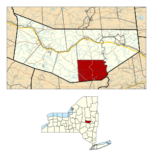
Location in Montgomery County and the state of New York.
|
|
| Country | United States |
| State | New York |
| County | Montgomery |
| Government | |
| • Type | Town Council |
| Area | |
| • Total | 42.87 sq mi (111.02 km2) |
| • Land | 42.01 sq mi (108.80 km2) |
| • Water | 0.86 sq mi (2.22 km2) |
| Elevation | 1,250 ft (381 m) |
| Population
(2010)
|
|
| • Total | 1,373 |
| • Estimate
(2016)
|
1,333 |
| • Density | 31.73/sq mi (12.25/km2) |
| Time zone | UTC-5 (Eastern (EST)) |
| • Summer (DST) | UTC-4 (EDT) |
| FIPS code | 36-057-13816 |
| GNIS feature ID | 0978810 |
Charleston is a small town in Montgomery County, New York, United States. In 2010, about 1,373 people lived there. The town was named after an early settler named Charles Van Epps.
The Town of Charleston is located on the southern edge of Montgomery County. It is southwest of the City of Amsterdam. Charleston is special because it is the only town in the county that does not touch the Mohawk River.
Contents
History of Charleston
People started settling in the area that is now Charleston even before the American Revolution (the war for independence). Parts of Charleston were once part of old land grants from the 1700s.
The Town of Charleston was officially created in 1793. It was formed when the original "Town of Mohawk" was divided. This division also created the Town of Florida. Later, in 1823, Charleston became smaller when parts of it were used to create the towns of Glen and Root.
The First Baptist Church in Charleston is a very old building. It was added to the National Register of Historic Places in 1994. This means it is an important historical site.
Geography of Charleston
Charleston covers a total area of about 42.8 square miles (111 square kilometers). Most of this area is land, with a small amount of water.
The southern border of the town touches Schoharie County. The eastern border of Charleston is marked by the Schoharie Creek.
Two main roads pass through Charleston. New York State Route 30A runs from north to south. New York State Route 162 crosses the southwestern part of the town.
Population of Charleston
| Historical population | |||
|---|---|---|---|
| Census | Pop. | %± | |
| 1820 | 5,365 | — | |
| 1830 | 2,148 | −60.0% | |
| 1840 | 2,103 | −2.1% | |
| 1850 | 2,216 | 5.4% | |
| 1860 | 1,837 | −17.1% | |
| 1870 | 1,601 | −12.8% | |
| 1880 | 1,334 | −16.7% | |
| 1890 | 1,174 | −12.0% | |
| 1900 | 1,052 | −10.4% | |
| 1910 | 900 | −14.4% | |
| 1920 | 785 | −12.8% | |
| 1930 | 594 | −24.3% | |
| 1940 | 609 | 2.5% | |
| 1950 | 575 | −5.6% | |
| 1960 | 546 | −5.0% | |
| 1970 | 658 | 20.5% | |
| 1980 | 1,013 | 54.0% | |
| 1990 | 1,107 | 9.3% | |
| 2000 | 1,292 | 16.7% | |
| 2010 | 1,373 | 6.3% | |
| 2016 (est.) | 1,333 | −2.9% | |
| U.S. Decennial Census | |||
In 2000, there were 1,292 people living in Charleston. These people lived in 472 households, and 343 of these were families. The population density was about 30 people per square mile.
About 34.7% of the households had children under 18 years old living with them. Many households (60.8%) were married couples. About 10.6% of the population was 65 years old or older. The average age of people in Charleston was 37 years.
Places in Charleston
Here are some of the smaller communities and locations you can find in the Town of Charleston:
- Burtonville – This is a small village located at the eastern edge of the town, near the Schoharie Creek.
- Charleston (also known as "Riders Corners") – This is the main village of Charleston, found along NY-30A.
- Charleston Four Corners – A small village located southwest of Charleston village, on NY-162.
- Davis Corners – A spot southwest of Charleston village, also on NY-30A.
- Fox Corners – Another location southwest of Charleston village.
- Lib Corners – You can find this spot northeast of Oak Ridge.
- Lost Valley – This location is at the eastern town line and the Schoharie River, just north of Burtonville.
- Market Corners – A place located between Charleston village and Oak Ridge, along NY-30A.
- Oak Ridge – A village south of Charleston village on NY-30A, close to the southern town border.
- Rockwell Corners – A location found near the southern boundary of the town.
See also
 In Spanish: Charleston (Nueva York) para niños
 | Frances Mary Albrier |
 | Whitney Young |
 | Muhammad Ali |

