Palatine, New York facts for kids
Quick facts for kids
Palatine, New York
|
|
|---|---|

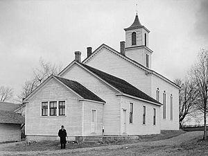
Trinity Lutheran Church in Stone Arabia (1936)
|
|

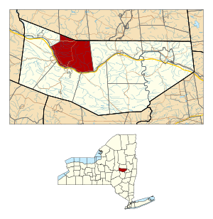
Location in Montgomery County and the state of New York.
|
|
| Country | United States |
| State | New York |
| County | Montgomery |
| Government | |
| • Type | Town Council |
| Area | |
| • Total | 41.70 sq mi (108.00 km2) |
| • Land | 41.07 sq mi (106.37 km2) |
| • Water | 0.63 sq mi (1.63 km2) |
| Elevation | 778 ft (237 m) |
| Population
(2010)
|
|
| • Total | 3,240 |
| • Estimate
(2016)
|
3,203 |
| • Density | 77.99/sq mi (30.11/km2) |
| Time zone | UTC-5 (Eastern (EST)) |
| • Summer (DST) | UTC-4 (EDT) |
| FIPS code | 36-56099 |
| GNIS feature ID | 0979337 |
The Town of Palatine is a community in Montgomery County, New York, United States. It is located on the north side of the Mohawk River. This area is in the northwestern part of the county.
In 2010, about 3,240 people lived here. This was the highest population since the 1820s. The town's name comes from the Palatinate region in Germany. This was the home of the first European settlers in this area. The main offices for the town are in Palatine Bridge.
Contents
History of Palatine
Early Settlers
In the mid-1700s, many settlers in this area were from the Palatinate in Germany. They were called Palatines. They had to leave their homes because of attacks by French forces.
In 1710, Queen Anne of England helped thousands of Palatines travel to the colony. They first worked in camps along the Hudson River to pay for their journey.
Building and Growth
The Palatines built the Palatine Church in 1770. This church still holds Lutheran services today. It was added to the National Register of Historic Places in 1973. This means it is an important historical site.
The Town of Palatine was officially formed in 1788. This happened after the American Revolutionary War. It was created from an older area called the "Palatine District." Over time, parts of Palatine were used to form other towns. For example, the town of Salisbury was formed in 1797. The town of St. Johnsville was also created from parts of Palatine.
Geography
Palatine covers a total area of about 41.7 square miles (108 square kilometers). Most of this area, about 41.2 square miles (106.37 square kilometers), is land. The rest, about 0.5 square miles (1.63 square kilometers), is water.
The Mohawk River forms the southern border of the town. The northern border of Palatine is shared with Fulton County.
Population Information
| Historical population | |||
|---|---|---|---|
| Census | Pop. | %± | |
| 1820 | 3,936 | — | |
| 1830 | 2,745 | −30.3% | |
| 1840 | 2,823 | 2.8% | |
| 1850 | 2,856 | 1.2% | |
| 1860 | 2,605 | −8.8% | |
| 1870 | 2,814 | 8.0% | |
| 1880 | 2,786 | −1.0% | |
| 1890 | 2,871 | 3.1% | |
| 1900 | 2,569 | −10.5% | |
| 1910 | 2,517 | −2.0% | |
| 1920 | 2,232 | −11.3% | |
| 1930 | 2,287 | 2.5% | |
| 1940 | 2,420 | 5.8% | |
| 1950 | 2,529 | 4.5% | |
| 1960 | 2,556 | 1.1% | |
| 1970 | 2,711 | 6.1% | |
| 1980 | 2,819 | 4.0% | |
| 1990 | 2,787 | −1.1% | |
| 2000 | 3,061 | 9.8% | |
| 2010 | 3,240 | 5.8% | |
| 2016 (est.) | 3,203 | −1.1% | |
| U.S. Decennial Census | |||
In 2000, there were 3,070 people living in Palatine. There were 1,135 households, which are groups of people living together. The average household had about 2.64 people.
The population was spread out by age. About 26.4% of the people were under 18 years old. About 18.4% were 65 years old or older. The average age in the town was 39 years.
Communities and Locations
Palatine has several smaller communities and important places:
- Big Nose – This is a well-known landmark at the town's southeastern border. It is part of a pair of cliffs called "The Noses" along the Mohawk River.
- Christmans Corners – A small area located in the northern part of the town.
- Cook Corners – A small village south of Stone Arabia. It is found on Route 10 where it meets Dillenbeck Road.
- Cranes Landing – This used to be a community in the western part of the town.
- East Stone Arabia – A small village located east of Stone Arabia. The Salem United Methodist Church is here.
- McKinley – A location in the southeastern part of the town. The Van Wie Farmstead, an old farm, was added to the National Register of Historic Places in 2011.
- Nelliston – This village is on the Mohawk River. It is across from Fort Plain.
- Palatine Bridge – This village is also on the Mohawk River. It is across from Canajoharie. Several historic buildings here are on the National Register of Historic Places. These include the Frey House and the Webster Wagner House.
- Palatine Church – This was once a community in the northwestern part of the town.
- Stone Arabia – A small village on Route 10, northeast of Palatine Bridge. Many Amish people live here. It is home to the Trinity Lutheran Church and Cemetery and the Reformed Dutch Church of Stone Arabia. It was also the site of a small battle during the American Revolution in 1780.
See also
 In Spanish: Palatine (Nueva York) para niños
 | Emma Amos |
 | Edward Mitchell Bannister |
 | Larry D. Alexander |
 | Ernie Barnes |

