
St. Johnsville, New York facts for kids
Quick facts for kids
St. Johnsville
|
|
|---|---|

Location in Montgomery County and the state of New York.
|
|
.svg)
Location of New York in the United States
|
|
| Country | United States |
| State | New York |
| County | Montgomery |
| Area | |
| • Total | 17.36 sq mi (44.96 km2) |
| • Land | 16.84 sq mi (43.62 km2) |
| • Water | 0.52 sq mi (1.34 km2) |
| Population
(2010)
|
|
| • Total | 2,631 |
| • Estimate
(2016)
|
2,535 |
| • Density | 150.52/sq mi (58.12/km2) |
| Time zone | EST |
| • Summer (DST) | EDT |
| ZIP code |
13452
|
| FIPS code | 36-057-64650 |
St. Johnsville is a town in Montgomery County, New York, United States. In 2010, about 2,631 people lived there.
The name St. Johnsville might come from an early surveyor named Alexander St. John. Some also believe it was named after an old church in the area called St. John's Church.
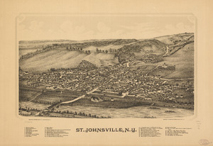
The Town of St. Johnsville is in the northwest part of Montgomery County. It includes a village also called St. Johnsville. Both the town and the village are located roughly halfway between the cities of Utica and Amsterdam.
The Erie Canal, which is part of the Mohawk River, runs along the town's southern edge.
Contents
History of St. Johnsville
People first started settling in this area around 1725. This land was once part of the Palatine District.
In 1769, Sir William Johnson built a church in the town. He built it for his Native American allies.
A small fight happened in the town in 1780. It took place near Fort Klock, which was a strong, fortified house.
The Town of St. Johnsville was officially created in 1838. It was formed from a part of the Town of Oppenheim. Oppenheim later became part of the new Fulton County.
In 1857, the community of St. Johnsville became its own village. This meant it had its own local government.
In 1934, Mr. and Mrs. Joseph H. Reaney gave 120 acres of land to the Village of St. Johnsville. This land was named Klock Park. It was named after Dr. Charles M. Klock, a respected local doctor. Today, a club called the H.C Smith Benefit Club uses a building in the park for many community events.
Several important places in St. Johnsville are listed on the National Register of Historic Places. These include:
- The First Methodist Episcopal Church of St. Johnsville
- Fort Klock
- The Enlarged Double Lock No. 33 Old Erie Canal
- Nellis Tavern
- The Margaret Reaney Memorial Library
Geography of St. Johnsville
St. Johnsville covers about 17.4 square miles (45.0 square kilometers). Most of this area is land. About 0.5 square miles (1.4 square kilometers) is water.
The Mohawk River forms the southern border of the town. The northern border touches Fulton County. The western border is shared with Herkimer County. This border is marked by East Canada Creek.
St. Johnsville is the smallest town in Montgomery County when you look at its size.
Important roads in the town include:
- NY-5: This highway runs east-west in the southern part of the town.
- NY-67: This road starts at NY-5, just east of St. Johnsville village.
- NY-331: The southern end of this road is near the northwest part of the town.
Population and People
| Historical population | |||
|---|---|---|---|
| Census | Pop. | %± | |
| 1840 | 1,923 | — | |
| 1850 | 1,627 | −15.4% | |
| 1860 | 1,688 | 3.7% | |
| 1870 | 2,189 | 29.7% | |
| 1880 | 2,062 | −5.8% | |
| 1890 | 2,081 | 0.9% | |
| 1900 | 2,674 | 28.5% | |
| 1910 | 3,369 | 26.0% | |
| 1920 | 3,123 | −7.3% | |
| 1930 | 3,000 | −3.9% | |
| 1940 | 2,974 | −0.9% | |
| 1950 | 2,934 | −1.3% | |
| 1960 | 2,958 | 0.8% | |
| 1970 | 2,915 | −1.5% | |
| 1980 | 3,064 | 5.1% | |
| 1990 | 2,773 | −9.5% | |
| 2000 | 2,567 | −7.4% | |
| 2010 | 2,631 | 2.5% | |
| 2016 (est.) | 2,535 | −3.6% | |
| U.S. Decennial Census | |||
In 2000, there were 2,565 people living in St. Johnsville. They lived in 1,043 households. About 658 of these were families.
The population density was about 152 people per square mile. There were 1,170 homes, with about 70 homes per square mile. Most people living in the town were White (98.67%).
About 27.8% of households had children under 18 living with them. About 45.7% were married couples. Around 31.5% of households were made up of single people. About 17.5% of households had someone aged 65 or older living alone.
The average household had 2.35 people. The average family had 2.91 people.
The population's age groups were:
- 23.4% were under 18 years old.
- 8.0% were between 18 and 24.
- 24.1% were between 25 and 44.
- 22.4% were between 45 and 64.
- 22.1% were 65 years or older.
The average age in the town was 41 years. For every 100 females, there were about 91.6 males.
Places in St. Johnsville
Here are some important communities and locations found within the Town of St. Johnsville:
- East Canada Creek – This is a stream that forms the western border of the town.
- Fort Klock – This is a historic fortified house. Johannes Klock built it in 1750. You can find it east of St. Johnsville village on the south side of NY-5. The site also has other old buildings that have been rebuilt or moved there.
- Klock Park – This park is located northwest of St. Johnsville village. It is named after Dr. Charles M. Klock.
- St. Johnsville – This is the main village in the town. It is located on the north side of the Mohawk River, along NY-5.
- West St. Johnsville (or Upper St. Johnsville) – This is a small community (called a hamlet) located west of St. Johnsville village on NY-5.
See also
 In Spanish: St. Johnsville (Nueva York) para niños
