Palatinate (region) facts for kids
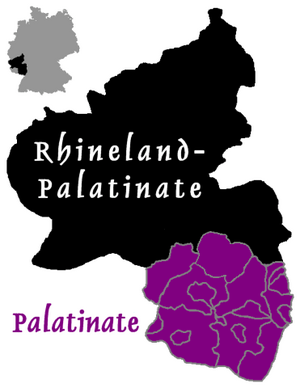
The Palatinate (pronounced Pfalz in German) is a special region in southwestern Germany. It covers about a quarter of the German state called Rhineland-Palatinate. This area is about 5,451 square kilometers (2,105 square miles) and has around 1.4 million people. The people who live here are known as Palatines.
Contents
Geography of the Palatinate
The Palatinate shares borders with several other regions. To the west, it borders Saarland. In the northwest, the Hunsrück mountains separate it from the Rhineland. The Upper Rhine river forms the eastern border with Hesse and the Baden region. To the south, the border with France separates it from Alsace.
A big part of the region, about one-third, is covered by the Palatinate Forest (Pfälzerwald). This forest is very popular for hiking. It's Germany's largest continuous forest, covering about 1,771 square kilometers (684 square miles). It's also part of a special nature reserve that crosses into France.
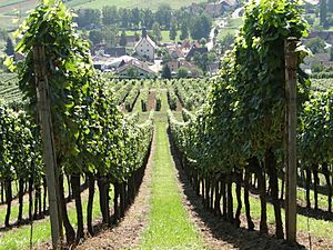
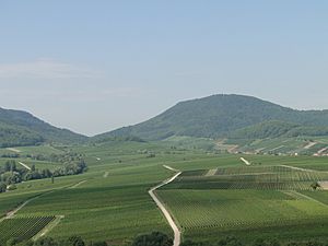
The western and northern parts of the Palatinate are mostly mountains and dense forests. The highest mountain is the Donnersberg, which is 687 meters (2,254 feet) tall. Most of the larger towns, like Ludwigshafen, Speyer, and Landau, are in the flatter eastern part near the Rhine River. This area is also home to the German Wine Route (Deutsche Weinstraße). It's one of Germany's top wine-making areas, known for its high-quality white and red wines.
Important rivers in the Palatinate include the Lauter, Queich, and Speyerbach, which flow into the Upper Rhine. In the west, you'll find the Schwarzbach and Glan rivers.
Regions of the Palatinate
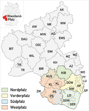
The Palatinate is divided into four main areas, each with its own districts and towns:
- North Palatinate (Nordpfalz): This area has fewer people and includes the Donnersbergkreis district.
- Anterior Palatinate (Vorderpfalz): This region is between the Upper Rhine and the Haardt mountains. It includes the Bad Dürkheim and Rhein-Pfalz-Kreis districts, along with cities like Frankenthal, Ludwigshafen, Neustadt an der Weinstraße, and Speyer.
- South Palatinate (Südpfalz): This area includes the Germersheim and Südliche Weinstraße districts, plus the town of Landau.
- West Palatinate (Westpfalz): This part includes the Kaiserslautern (district), Kusel, and Südwestpfalz districts. It also has the cities of Kaiserslautern, Pirmasens, and Zweibrücken.
Climate and Nature
The Palatinate has a mild climate, similar to many parts of Europe, influenced by the Atlantic. The average temperature is about 10 degrees Celsius. Because of the warm, wet winds, the Rhine Valley here is warm enough for special plants. You can find almond and fig trees, stone pines, Mediterranean Cypress, and even some palms. The lower hills are famous for their large chestnut forests. Some people even call this area "German Tuscany" because of its beautiful scenery.
History of the Palatinate
Long ago, this area was home to the Celts. Around 12 BCE, the Roman Empire took control, and it became part of a Roman province. Later, during the fall of the Roman Empire, Alamanni tribes settled here. Around 496, the Franks, led by King Clovis I, conquered the area. It then became part of the eastern Frankish kingdom, which later became East Francia in 843.
The Holy Roman Empire Era
From the Middle Ages until 1792, the Palatinate was split into many smaller areas. The most important of these was the Electorate of the Palatinate (Kurpfalz). This was a group of lands on both sides of the Rhine River. The ruler of these lands, called the Count Palatine, became one of the seven most powerful nobles in the Holy Roman Empire. These nobles had the special job of electing the Emperor. This was made official in 1356.
In 1214, the House of Wittelsbach family from Bavaria took over these lands. They ruled the Palatinate until 1918. Another important area was the Bishopric of Speyer, which was ruled by a bishop. The city of Landau was a "Free Imperial City," meaning it was independent, but it was later taken by France after the Thirty Years' War.
French Control
In 1794, French revolutionary soldiers took over the Palatinate. In 1797, France officially took control of the region. They changed how the area was governed, creating new departments. Most of the Palatinate became the Département of Mont Tonnerre. The French also brought their laws and the metric system to the region.
Bavarian Control
After Napoleon was defeated in 1813, the Palatinate came under the control of Austria and Bavaria. In 1816, a treaty was signed, and the Palatinate officially became part of the Kingdom of Bavaria.
The Bavarian royal family tried to make the Palatinate feel more connected to Bavaria. They built a royal palace and helped restore Speyer Cathedral. The new city of Ludwigshafen was even named after the Bavarian King Ludwig I. However, people from the Palatinate often felt they were more modern and liberal than the rest of Bavaria, partly because of the changes the French had brought.
In 1849, some people in the Palatinate wanted to break away from Bavaria and form their own republic. But this uprising was stopped by Prussian soldiers. The Palatinate remained part of Bavaria even after Germany became an empire in 1871, and after Bavaria became a free state in 1918.
After World War I, French troops occupied the Palatinate again. In 1920, some western parts of the Palatinate became part of the new Saarland. Also, several towns, including Speyer, Ludwigshafen, and Kaiserslautern, became independent cities.
Between 1919 and 1923, some groups tried to separate the Palatinate from Bavaria and Germany with French support. These attempts failed, and by 1924, it was confirmed that the Palatinate would remain part of Bavaria.
During Nazi rule (1933-1945), the Palatinate was still officially part of Bavaria, but it was merged with the Saarland into a larger region called Gau Westmark.
Forming Rhineland-Palatinate
After World War II, Germany was divided into occupation zones. The Palatinate was in the French zone, while Bavaria was in the U.S. zone. To reorganize their zone, the French created new states. In 1947, the Palatinate was combined with other regions to form the new German state of Rhineland-Palatinate.
The Palatinate was initially one of five administrative districts in Rhineland-Palatinate. Later, in 1968, it was merged with another district. Finally, on January 1, 2000, all administrative districts in Rhineland-Palatinate were dissolved. However, the historic borders of the Palatinate are still important for the local churches.
German Americans and the Palatinate
Many people from the Palatinate moved to America, especially in the 18th and 19th centuries. The Pennsylvania Dutch language, spoken by groups like the Amish in the United States, comes mostly from the Palatine German language. Many Mennonite refugees brought this language to Pennsylvania between 1717 and 1732.
For a while, "Palatine" was a common name for German Americans in the U.S. Famous Americans have roots here. Johann Heinrich Heinz, whose son founded the H. J. Heinz Company, came from Kallstadt, Palatinate, in 1840. Frederick Trump, the grandfather of Donald Trump, was also born in Kallstadt and moved to New York City in 1885.
Palatinate Cuisine
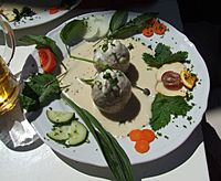
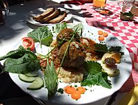
One of the most famous dishes in the Palatinate is saumagen, which means "sow's stomach." It's a dish with a crispy casing stuffed with pork, potatoes, and spices. Other traditional meat dishes include bratwurst, Palatinate liverwurst, and different kinds of dumplings like lewwerknepp (liver dumplings) and fleeschknepp (meat dumplings).
Sauerkraut is a common side dish, especially in winter, often served with mashed potatoes and gravy. Another popular food is dampfnudels, which are steamed dumplings. They can be eaten with sweet sauces, like vanilla sauce or fruit, or with savory dishes like potato soup or goulash.
See also
 In Spanish: Palatinado Renano para niños
 | Calvin Brent |
 | Walter T. Bailey |
 | Martha Cassell Thompson |
 | Alberta Jeannette Cassell |


