
Amsterdam (town), New York facts for kids
Quick facts for kids
Amsterdam, New York
|
|
|---|---|

Location within Montgomery County and the state of New York.
|
|
| Country | United States |
| State | New York |
| County | Montgomery |
| Government | |
| • Type | Town council |
| Area | |
| • Total | 30.37 sq mi (78.67 km2) |
| • Land | 29.64 sq mi (76.77 km2) |
| • Water | 0.73 sq mi (1.90 km2) |
| Elevation | 666 ft (203 m) |
| Population
(2010)
|
|
| • Total | 5,566 |
| • Estimate
(2016)
|
6,010 |
| • Density | 202.75/sq mi (78.28/km2) |
| Time zone | UTC−05 (Eastern (EST)) |
| • Summer (DST) | UTC−04 (EDT) |
| ZIP code |
12010
|
| Area code(s) | 518 |
| FIPS code | 36-057-02077 |
| GNIS feature ID | 0978678 |
Amsterdam is a town in Montgomery County, New York, United States. It is named after Amsterdam, the capital city of the Netherlands. In 2010, about 5,566 people lived there.
The town of Amsterdam is next to the city of Amsterdam. It surrounds the city on three sides. The town is located on the northeastern edge of Montgomery County. The Mohawk River, which is part of the Erie Canal, flows along the town's southern border.
Contents
History of Amsterdam Town
Early Settlements and Native Americans
Before Europeans arrived, the powerful Mohawk tribe lived in this area. They were part of the Iroquois group of Native Americans.
The first European settlers came around 1715. However, most people did not move here until Sir William Johnson set up his main base. He built a place called Fort Johnson (also known as Mount Johnson). This was before he started the city of Johnstown.
Town Formation and Growth
The town of Amsterdam was officially created in 1793. It was formed from a part of an older town called Caughnawaga.
In 1838, the village of Amsterdam was made official in the southern part of the town. As this village grew, it became the city of Amsterdam. It also took over more land from the town. Another town, Perth, was also created from Amsterdam in 1838.
By 1865, the town of Amsterdam had a population of 5,135 people.
Historic Places in Amsterdam
Two important historical places in the town are listed on the National Register of Historic Places. These are the Hurricana Stock Farm and the Samuel and Johanna Jones Farm. These places help us remember the town's past.
Geography of Amsterdam Town
Land and Water Features
The town of Amsterdam covers about 30.3 square miles (78.67 square kilometers). Most of this area is land, about 29.7 square miles (76.77 square kilometers). The rest, about 0.6 square miles (1.90 square kilometers), is water.
The northern border of the town is shared with Fulton County. The Mohawk River forms the southern border. To the east, the town borders both Saratoga County and Schenectady County.
Major Roads
Several main roads run through the area. New York State Route 5 and New York State Route 67 are highways that go from east to west. They sometimes join together near the Mohawk River. These roads also cross New York State Route 30 in the city of Amsterdam. Route 30 runs from north to south.
Population Information
| Historical population | |||
|---|---|---|---|
| Census | Pop. | %± | |
| 1820 | 3,171 | — | |
| 1830 | 3,354 | 5.8% | |
| 1840 | 5,333 | 59.0% | |
| 1850 | 4,128 | −22.6% | |
| 1860 | 4,557 | 10.4% | |
| 1870 | 7,706 | 69.1% | |
| 1880 | 11,710 | 52.0% | |
| 1890 | 2,948 | −74.8% | |
| 1900 | 3,202 | 8.6% | |
| 1910 | 3,074 | −4.0% | |
| 1920 | 3,130 | 1.8% | |
| 1930 | 3,818 | 22.0% | |
| 1940 | 3,911 | 2.4% | |
| 1950 | 4,698 | 20.1% | |
| 1960 | 5,400 | 14.9% | |
| 1970 | 5,795 | 7.3% | |
| 1980 | 5,721 | −1.3% | |
| 1990 | 5,962 | 4.2% | |
| 2000 | 5,820 | −2.4% | |
| 2010 | 5,566 | −4.4% | |
| 2016 (est.) | 6,010 | 8.0% | |
| U.S. Decennial Census | |||
According to the census from 2010, there were 5,566 people living in the town. The population density was about 196 people per square mile. This means there were about 196 people living in each square mile of land.
The town had 2,243 households. About 27% of these households had children under 18 living there. The average age of people in the town was 44 years old.
Communities and Locations
- Chuctenunda Creek – A small river that flows into the Mohawk River. It runs through the city of Amsterdam.
- Church Corners – A small village located near the western border of the town, on Route 67.
- Cranesville – A small village east of Amsterdam city. It is on Route 5, next to the Mohawk River. This community is named after an early settler named David Crane.
- Crescent Park – A small village located northeast of Amsterdam city.
- Evas Kill – A stream that flows into the Mohawk River. It is named after Evas van Alstyne, who was killed by Native Americans there.
- Fort Johnson – A village located west of Amsterdam city on Route 5.
- Hagaman – A village northeast of Amsterdam city. It used to be called "Hagamans Mills" and is located on the Chuctenunda Creek.
- Harrower – A small village located northeast of Amsterdam city.
- Harrower Pond – A wider part of the Chuctanunda Creek.
- Manny Corners – A small village located northeast of Amsterdam city.
- Rockton – A small village on the northern edge of Amsterdam city.
- Tribes Hill – A small village on the western town line, on Route 5. It was once a meeting place for local Native American tribes.
- Wallins Corners – A small village located north of the City of Amsterdam.
Images for kids
-
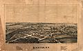
Perspective map of Rockton and a list of landmarks published in 1890 by L.R. Burleigh

See also
 In Spanish: Amsterdam (pueblo) para niños
