Finger Lakes National Forest facts for kids
Quick facts for kids Finger Lakes National Forest |
|
|---|---|

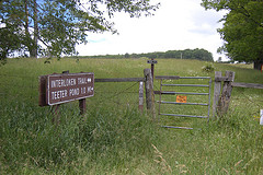
Trailhead for the Interloken Trail, running through pastureland in the Finger Lakes National Forest
|
|
| Location | New York, United States |
| Nearest city | Ithaca, NY |
| Area | 16,259 acres (65.80 km2) |
| Established | 1985 |
| Governing body | U.S. Forest Service |
| Website | Green Mountain & Finger Lakes National Forests |
The Finger Lakes National Forest is a special outdoor area in New York State. It covers about 16,259 acres (which is about 66 square kilometers). This forest is located between two large lakes, Seneca Lake and Cayuga Lake.
It's the only National Forest in New York. This means it's public land managed for many uses. You can find over 30 miles (50 km) of trails here. These trails go through deep valleys, open fields, and thick forests.
Contents
A Look Back: Early History of the Forest
The land that is now the Finger Lakes National Forest was once home to the Iroquois people. They lived here many years ago. It's believed they used this area for hunting.
About 250 years ago, this land was covered in trees. It was a hunting ground for the Iroquois. But 100 years ago, most of the trees were gone. This happened because European settlers cut them down for logging and farming.
Today, the forest is a mix of new growth trees and open fields. You can still find old cellar holes and stone walls. These are reminders of the people who lived here long ago. These historical sites are protected by law.
The Iroquois were one of many Native American groups who lived here for over 10,000 years. The lakes nearby, Cayuga and Seneca, are named after two Iroquois nations. The forest area was good for hunting and gathering nuts.
The American Revolution and Land Changes
During the American Revolution, the Iroquois people sided with the British. Because of this, George Washington sent Generals Sullivan and Clinton to fight against them.
In 1779, the Sullivan Expedition destroyed many Iroquois villages. They also ruined their fields and food supplies. After the war, this land became available. It was given to Colonial soldiers as payment for their service.
The land was divided into "military lots." These were one-mile square (2.6 square km) sections. This old system still shapes the roads and trails in the forest today. In 1790, these lots were given to Revolutionary War veterans.
Early settlers cleared the land to grow hay and grains like buckwheat. Farmers did well for a while. But by the mid-1800s, things changed. Cars became popular, so fewer horses needed hay. The soil also became less fertile. Farmers from the Midwest also offered cheaper crops.
How the Forest Became Federal Land
Between 1890 and the Great Depression, over a million acres of farmland in New York were left empty. In the 1930s, the government realized many farmers couldn't make a living. Their land was worn out.
New laws were passed to help. One agency, the Resettlement Administration, bought poor farmland. Between 1938 and 1941, over 100 farms in this area were purchased. The government bought land from willing sellers. This created a "patchwork quilt" of federal land. This pattern still exists today.
The new federal land was called the Hector Land Use Area (LUA). It was first managed to help the soil. They planted pine trees and started a grazing program. Old farm fields became improved pastures. This showed how the land could still be useful.
In 1943, the Hector Cooperative Grazing Association was formed. They managed grazing for many livestock owners. In 1996, the Queen's Castle property was added to the forest. This historic building is now listed on the National Register of Historic Places.
Becoming a National Forest
By the 1950s, the Hector LUA had met its goals. Farmers were helped, soil was stable, and new farming methods were shown. People also wanted public lands to be used for many things.
So, in 1954, the U.S. Forest Service took over. They had experience managing land for multiple uses. At first, it was managed from Pennsylvania. Later, it became part of the Green Mountain National Forest in Vermont.
In 1982, the government looked at selling some federal lands. The Hector Land Use Area was considered. But local people strongly wanted the government to keep it. They used Hector for wood, grazing, and outdoor fun.
Because of this public support, Congress made it a permanent part of the National Forest System. It was first called the Hector Ranger District. But local people asked for a name change. In October 1985, it became the Hector Ranger District, Finger Lakes National Forest. This helped visitors and made local people proud.
The Forest Today
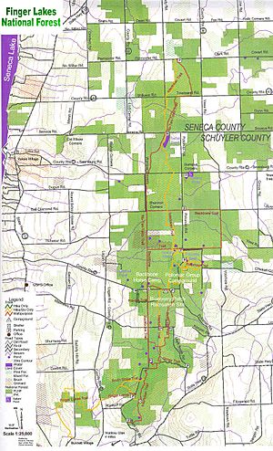
The Finger Lakes National Forest is a valuable public resource. It's located in Seneca and Schuyler counties. It sits between Cayuga Lake and Seneca Lake.
The forest is managed by the Forest Service. They have offices in Rutland, Vermont. The forest continues to be managed for pastures, trees, recreation, and wildlife. It also protects important historical and archaeological sites.
The Finger Lakes National Forest is the second-smallest National Forest in the United States. Only the Tuskegee National Forest in Alabama is smaller.
 | William Lucy |
 | Charles Hayes |
 | Cleveland Robinson |


