
Waterloo (village), New York facts for kids
Quick facts for kids
Waterloo
|
|
|---|---|
|
Village
|
|

United States Post Office (Waterloo, New York)
|
|
| Nickname(s):
waterloo
|
|

Waterloo (village), New York
Location in New York
|
|
| Country | United States |
| State | New York |
| County | Seneca |
| Town(s) | Waterloo and Fayette |
| Incorporated | April 9, 1824 |
| Government | |
| • Type | Board of Trustees |
| Area | |
| • Total | 2.20 sq mi (5.71 km2) |
| • Land | 2.16 sq mi (5.59 km2) |
| • Water | 0.05 sq mi (0.12 km2) |
| Elevation | 453 ft (138 m) |
| Population
(2020)
|
|
| • Total | 4,810 |
| • Density | 2,229.95/sq mi (860.99/km2) |
| Time zone | UTC-5 (Eastern (EST)) |
| • Summer (DST) | UTC-4 (EDT) |
| ZIP code |
13165
|
| Area code(s) | 315 and 680 |
| FIPS code | 36-78553 |
| GNIS feature ID | 0968900 |
| Website | http://www.waterloony.com/ |
Waterloo is a village in New York, United States. It is one of the main county seats for Seneca County. The village is named after Waterloo, Belgium, where Napoleon was defeated.
Waterloo is the most populated village in Seneca County. Most of the county's main offices are located here. The village is mostly in the Town of Waterloo. Parts of it are also in the Town of Fayette and the Town of Seneca Falls. Waterloo is located between two large lakes, Seneca Lake and Cayuga Lake.
Contents
A Look at Waterloo's Past
The area where Waterloo is now was once home to the Cayuga nation. They were a Native American group and part of the Iroquois League. Around the year 1500, a Cayuga village called "Skoiyase" was here. This name means "flowing water."
In the 17th century, Jesuit missionaries visited the Cayuga people. Later, in 1779, a military group called the Sullivan Expedition destroyed Skoiyase. Many Native Americans then left the area. The land was later set aside for soldiers who had served in the military.
Early Settlers and Names
The first new settler, Jabez Gorham, arrived around 1795. The early village was first known as "New Hudson." It was also called "Scoys," which came from the old Native American village name.
Waterloo Becomes a County Seat
Waterloo became a county seat in 1819. A county seat is like a main town where government offices are located. At first, Ovid was the only county seat. But after some land changes, Waterloo also became a county seat.
Today, Seneca County still has two county seats: Waterloo and Ovid. However, most government activities happen in Waterloo. The County Board of Supervisors still holds at least one meeting a year in Ovid to remember this history.
The Birthplace of Memorial Day
Waterloo is famous for being the official birthplace of Memorial Day. This holiday honors soldiers who died serving their country. In 1966, President Lyndon B. Johnson officially recognized Waterloo for this. The Memorial Day Museum is located in the village.
However, some historians have questioned this claim. They found evidence that suggests the first Memorial Day in Waterloo might have been in 1868, not earlier. Despite this, Waterloo remains recognized for its role in the holiday's history.
Women's Rights Movement Connection
Important planning meetings for the first Women's Rights Convention took place in Waterloo in 1848. This convention was a major event for women's rights in the United States. It was held nearby in Seneca Falls.
Waterloo's Location and Landscape
Waterloo is located at 42°54′13″N 76°51′34″W / 42.90361°N 76.85944°W. The village covers about 2.2 square miles (5.6 square kilometers). Most of this area is land, with a small part being water.
The Seneca River and Cayuga-Seneca Canal flow through Waterloo. These waterways connect the village to the larger Erie Canal system. This system was very important for trade and travel in the past.
Major roads also cross through Waterloo. US Route 20 and New York State Route 5 meet New York State Route 96 here.
Historic Places in Waterloo
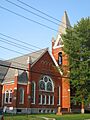
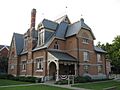
Waterloo has several buildings listed on the National Register of Historic Places. These places are important because of their history or special architecture. Some of them include:
- William H. Burton House
- First Presbyterian Church
- Hunt House: A historic home from around 1830.
- M'Clintock House: This home was important for the first Women's Rights Convention.
- Saint Paul's Church
- United Methodist Church
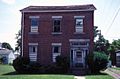
- U.S. Post Office
- Waterloo Library
- James Russell Webster House: A historic home built between 1850 and 1855.
Waterloo's Population
| Historical population | |||
|---|---|---|---|
| Census | Pop. | %± | |
| 1860 | 3,375 | — | |
| 1870 | 4,086 | 21.1% | |
| 1880 | 3,893 | −4.7% | |
| 1890 | 4,350 | 11.7% | |
| 1900 | 4,256 | −2.2% | |
| 1910 | 3,931 | −7.6% | |
| 1920 | 3,809 | −3.1% | |
| 1930 | 4,047 | 6.2% | |
| 1940 | 4,010 | −0.9% | |
| 1950 | 4,438 | 10.7% | |
| 1960 | 5,098 | 14.9% | |
| 1970 | 5,418 | 6.3% | |
| 1980 | 5,303 | −2.1% | |
| 1990 | 5,116 | −3.5% | |
| 2000 | 5,111 | −0.1% | |
| 2010 | 5,171 | 1.2% | |
| 2020 | 4,810 | −7.0% | |
| U.S. Decennial Census | |||
In 2010, about 5,171 people lived in Waterloo. By 2020, the population was 4,810. Most people living in the village are White (96.6%). About 1.1% are Black or African American. A small number of people are Asian or from other backgrounds. About 2.2% of the population is Hispanic or Latino.
The average age of people in Waterloo in 2010 was 42.3 years old. About 24.5% of the population was under 20 years old.
Famous People from Waterloo
- Tom Coughlin: He was a successful coach for the New York Giants football team. He won two Super Bowls. Tom Coughlin was born in Waterloo in 1946.
- George Bradshaw Kelly: He was a U.S. Representative for New York.
- Mike McLaughlin: A former NASCAR racing driver.
- Charles E. Stuart: He was a U.S. Representative and Senator from Michigan.
- Kevin Sylvester: A radio host for the Buffalo Sabres hockey team.
Images for kids
-
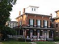
William H. Burton House
-

First Presbyterian Church
-
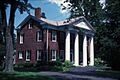
Jane Hunt House
-
Richard Hunt House (M'Clintock House)
-
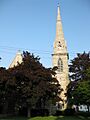
Saint Paul's Church
-
United Methodist Church
-
Waterloo Library


See also
 In Spanish: Waterloo (villa) para niños
