
Cayuga–Seneca Canal facts for kids
Quick facts for kids Oswego Canal |
|
|---|---|
| Specifications | |
| Length | 20 miles (32 km) |
| Locks | 4 |
| Status | open |
| Navigation authority | New York State Canal Corporation |
| History | |
| Date completed | 1818 |
| Geography | |
| Start point | Tyre, New York, on Seneca Lake (43°28′33″N 76°30′58″W / 43.4757°N 76.5161°W) |
| End point | confluence of Seneca River and the Erie Canal (43°00′16″N 76°43′45″W / 43.004393°N 76.729072°W) |
| Branch of | New York State Canal System |
| Connects to | Erie Canal |

The Cayuga–Seneca Canal is a special waterway in New York, United States. It is now part of the larger New York State Canal System. This canal connects the famous Erie Canal to two important lakes: Cayuga Lake and Seneca Lake. It stretches for about 20 miles (32 kilometers).
History of the Canal

The Seneca River, which later became the Cayuga–Seneca Canal, has always been very important for towns like Waterloo and Seneca Falls. It helped their economies grow.
In 1813, a private company called the Seneca Lock Navigation Co. was formed. They built dams and special water elevators called locks. These locks allowed boats to move goods easily to the Erie Canal. By 1818, a new canal opened that connected Cayuga and Seneca Lakes.
By 1823, many boats were using the lock at Waterloo every day. They carried things like flour, pork, lumber, and wool. On their return, they brought other products and goods. An early businessman named Job Smith started a company in 1787. His company helped travelers and boats get around a mile-long section of fast-moving water called "the Falls." This section had a 42-foot (13-meter) drop.
The locks at Seneca Falls were finished in 1818. More improvements were made between the lakes by 1821. These included eight stone locks and almost two miles of newly dug canal. To help industries grow even more, the fast-moving waters were dammed. This created the Upper, Middle, and Lower Falls. Soon after, in 1825, many new factories and businesses started to appear. In Seneca Falls, there was a lock for every important mill. These locks raised or lowered boats a total of 42 feet (13 meters).
In 1825, work began on a canal to link Seneca Lake with the new Erie Canal at Montezuma. The Cayuga–Seneca Canal officially opened in 1828. The canal was made even bigger in 1862. This led to a large industrial area called "the Flats" growing near the village center. Factories there made fire engines, pumps, and other iron goods. They also produced things like stove parts, corn shellers, and bells. A knitting mill even made socks, including 85,000 pairs for the Army and Navy.
The locks on the Cayuga–Seneca Canal were changed in 1918. This happened when New York State created the New York Barge Canal System. State engineers replaced five smaller locks with one very large two-part lock. This new lock had a 49-foot (15-meter) lift. It needed a lot of water to work. Because of this, the Flats industrial area was flooded. Many buildings were destroyed or moved to create a new body of water called Van Cleef Lake. The flooding was completed on August 20, 1915.
How the Locks Work
The Cayuga–Seneca Canal has 4 locks in total. Locks are like water elevators that help boats move between different water levels.
All locks on the New York State Canal System are single-chamber. This means they have one section for boats to enter. They are 328 feet (100 meters) long and 45 feet (13.7 meters) wide. The water inside is at least 12 feet (3.7 meters) deep over the bottom gates. These locks can hold a boat up to 300 feet (91 meters) long and 43.5 feet (13.3 meters) wide. The height of the lock walls changes. They can be between 28 feet (8.5 meters) and 61 feet (18.6 meters) tall, depending on how much the water level needs to change.
The distances mentioned below are from an online map. They might not be exactly the same as signs along the canal. The water levels are estimates from old canal records and signs. They should be accurate within about 6 inches (15.2 centimeters).
| Lock # | Location | Elevation
(upstream/west) |
Elevation
(downstream/east) |
Lift or Drop | Distance to Next Lock
(upstream/west) |
|---|---|---|---|---|---|
| CS1 | Cayuga | 381.5 ft (116.3 m) | 374.0 ft (114.0 m) | 7.5 ft (2.3 m) | CS2, 3.97 mi (6.39 km) |
| CS2 | Seneca Falls | 406.0 ft (123.7 m) | 381.5 ft (116.3 m) | 24.5 ft (7.5 m) | CS3, adjacent to Lock CS2. |
| CS3 | Seneca Falls | 430.5 ft (131.2 m) | 406.0 ft (123.7 m) | 24.5 ft (7.5 m) | CS4, 4.30 mi (6.92 km) |
| CS4 | Waterloo | 445.0 ft (135.6 m) | 430.5 ft (131.2 m) | 14.5 ft (4.4 m) | Seneca Lake, 4.96 mi (7.98 km) |
All surface elevations are approximate.
The Cayuga–Seneca Canal officially starts where the Seneca and Clyde rivers meet, near Mays Point. The connection to Cayuga Lake is just east of Lock CS1. At this point, the average water level is 382 feet (116.5 meters). From there, the canal turns sharply west. It continues towards Seneca Lake, where the average water level at the end is 445 feet (135.7 meters).
Images for kids
-
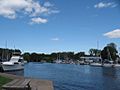
Cayuga–Seneca Canal from Seneca Lake State Park, Geneva, New York.
-
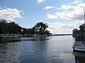
Cayuga–Seneca Canal at the Northern tip of Seneca Lake.
-
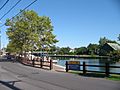
Cayuga–Seneca Canal from Seneca Falls, New York.


