Groton (village), New York facts for kids
Quick facts for kids
Groton, New York
|
|
|---|---|
|
Village
|
|
| Country | United States |
| State | New York |
| County | Tompkins |
| Settled | 1795 |
| Incorporated | June 11, 1860 |
| Named for | Uncertain, possibly named after Groton, Connecticut and Groton, Massachusetts, from where many early settlers hailed |
| Area | |
| • Total | 1.74 sq mi (4.50 km2) |
| • Land | 1.74 sq mi (4.50 km2) |
| • Water | 0.00 sq mi (0.00 km2) |
| Elevation | 997 ft (304 m) |
| Population
(2020)
|
|
| • Total | 2,145 |
| • Density | 1,234.89/sq mi (476.67/km2) |
| Time zone | UTC-5 (Eastern (EST)) |
| • Summer (DST) | UTC-4 (EDT) |
| ZIP code |
13073
|
| Area code(s) | 607 |
| FIPS code | 36-30961 |
| GNIS feature ID | 0951849 |
Groton is a small village located in Tompkins County, New York, in the United States. In 2020, about 2,145 people lived there.
This village is found near the center of the larger Town of Groton. It is northeast of Ithaca and west of Cortland.
Contents
History of Groton Village
Early Settlement and Growth
The area where Groton is located was once part of the Central New York Military Tract. This land was first settled by people from outside the area around 1795. Before that, Native Americans used the land for trails and the Owasco Inlet for water.
Groton became an official village in 1860. It was first part of Cayuga County until Tompkins County was created in 1817.
Railroad Connections
The village was once served by the Southern Central Railroad. Later, this railroad became part of the Lehigh Valley Railroad system. This helped connect Groton to other places.
Local Landmarks and Education
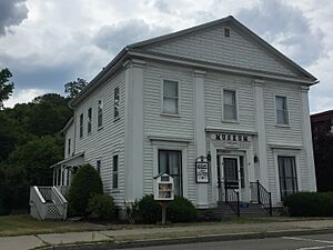
The Groton Historical Association Museum is an important local building. It is located at 172 Main Street and used to be a Baptist meetinghouse.
The original Groton High School building was added to the National Register of Historic Places in 1992. Today, students in Groton attend the Groton Junior/Senior High School.
Geography of Groton
Groton is located at 42°35′12″N 76°21′53″W / 42.58667°N 76.36472°W.
The village covers a total area of about 1.7 square miles (4.5 square kilometers). There is no water within the village limits.
Major roads like New York State Route 38 and New York State Route 222 meet in the village.
Population of Groton
| Historical population | |||
|---|---|---|---|
| Census | Pop. | %± | |
| 1870 | 863 | — | |
| 1880 | 923 | 7.0% | |
| 1890 | 1,280 | 38.7% | |
| 1900 | 1,344 | 5.0% | |
| 1910 | 1,260 | −6.2% | |
| 1920 | 2,235 | 77.4% | |
| 1930 | 2,004 | −10.3% | |
| 1940 | 2,087 | 4.1% | |
| 1950 | 2,150 | 3.0% | |
| 1960 | 2,123 | −1.3% | |
| 1970 | 2,112 | −0.5% | |
| 1980 | 2,313 | 9.5% | |
| 1990 | 2,398 | 3.7% | |
| 2000 | 2,470 | 3.0% | |
| 2010 | 2,363 | −4.3% | |
| 2020 | 2,145 | −9.2% | |
| U.S. Decennial Census | |||
In 2000, there were 2,470 people living in Groton. The population density was about 1,427 people per square mile.
The population included many families and individuals. About 27.4% of the people were under 18 years old. The average age in the village was 38 years.
Education in Groton
Students in Groton attend schools within the Groton Central School District.
See also
 In Spanish: Groton (villa) para niños
 | Laphonza Butler |
 | Daisy Bates |
 | Elizabeth Piper Ensley |


