
Dryden (village), New York facts for kids
Quick facts for kids
Dryden, New York
|
|
|---|---|
|
Village
|
|

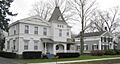
Dryden Historic District
|
|

Dryden (village), New York
Location in New York
|
|
| Country | United States |
| State | New York |
| County | Tompkins |
| Settled | 1797 |
| Incorporated | July 7, 1857 |
| Named for | John Dryden |
| Area | |
| • Total | 1.77 sq mi (4.58 km2) |
| • Land | 1.76 sq mi (4.55 km2) |
| • Water | 0.01 sq mi (0.04 km2) |
| Elevation | 1,089 ft (332 m) |
| Population
(2020)
|
|
| • Total | 1,887 |
| • Density | 1,074.60/sq mi (414.83/km2) |
| Time zone | UTC-5 (Eastern (EST)) |
| • Summer (DST) | UTC-4 (EDT) |
| ZIP code |
13053
|
| Area code(s) | 607 |
| FIPS code | 36-20951 |
| GNIS feature ID | 0948704 |
Dryden is a village in Tompkins County, New York, United States. It is located east of Ithaca and close to the border of Cortland County. In 2020, about 1,887 people lived in the village.
Contents
History of Dryden
The area where Dryden is located was once part of the Central New York Military Tract. This was a large piece of land set aside after the American Revolutionary War. It was used to pay soldiers for their service.
The first person to settle in the area that would become Dryden arrived in 1797. The village of Dryden officially became a village in 1857. This means it got its own local government.
Historic Places in Dryden
Several buildings and areas in Dryden are very old and important. They are listed on the National Register of Historic Places. This is a special list of places in the United States that are worth protecting. These include:
- Dryden Historic District
- Luther Clarke House
- Jennings-Marvin House
- Lacy-Van Vleet House
- Methodist Episcopal Church
- Rockwell House
- Southworth House
- Southworth Library
Famous People from Dryden
Many interesting people have come from Dryden. Here are a few:
- Jacob M. Appel — an author
- John Wilbur Dwight — a former US congressman (someone who helps make laws for the country)
- Milo Goodrich — also a former US congressman
- Richard P. Marvin — another former US congressman
- John Miller — the very first governor of North Dakota (a state leader)
Geography of Dryden
Dryden is located at coordinates 42°29′21″N 76°17′58″W. This helps people find it on a map.
The village covers a total area of about 1.7 square miles (4.3 square kilometers). Almost all of this area is land, with very little water.
Two important roads meet in Dryden: New York State Route 13 and New York State Route 38.
Population Information
| Historical population | |||
|---|---|---|---|
| Census | Pop. | %± | |
| 1870 | 672 | — | |
| 1880 | 779 | 15.9% | |
| 1890 | 663 | −14.9% | |
| 1900 | 699 | 5.4% | |
| 1910 | 709 | 1.4% | |
| 1920 | 707 | −0.3% | |
| 1930 | 666 | −5.8% | |
| 1940 | 747 | 12.2% | |
| 1950 | 976 | 30.7% | |
| 1960 | 1,263 | 29.4% | |
| 1970 | 1,490 | 18.0% | |
| 1980 | 1,761 | 18.2% | |
| 1990 | 1,908 | 8.3% | |
| 2000 | 1,832 | −4.0% | |
| 2010 | 1,890 | 3.2% | |
| 2020 | 1,887 | −0.2% | |
| U.S. Decennial Census | |||
In 2000, there were 1,832 people living in Dryden. The population density was about 1,105 people per square mile (427 people per square kilometer).
The average age of people in the village in 2000 was 37 years old. About 26.4% of the population was under 18 years old.
Education in Dryden
Students in Dryden attend schools within the Dryden Central School District. The main high school for the area is Dryden High School.
Images for kids
-
Dryden Historic District
See also
 In Spanish: Dryden (villa) para niños
