Venice, New York facts for kids
Quick facts for kids
Venice, New York
|
|
|---|---|

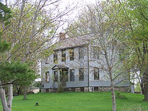
The Jethro Wood House in Poplar Ridge
|
|
| Country | United States |
| State | New York |
| County | Cayuga |
| Government | |
| • Type | Town Council |
| Area | |
| • Total | 41.29 sq mi (106.94 km2) |
| • Land | 41.09 sq mi (106.42 km2) |
| • Water | 0.20 sq mi (0.52 km2) |
| Elevation | 965 ft (294 m) |
| Population
(2010)
|
|
| • Total | 1,368 |
| • Estimate
(2016)
|
1,351 |
| • Density | 32.88/sq mi (12.70/km2) |
| Time zone | UTC-5 (Eastern (EST)) |
| • Summer (DST) | UTC-4 (EDT) |
| ZIP code |
13147
|
| Area code(s) | 315 |
| FIPS code | 36-011-77024 |
| GNIS feature ID | 0979579 |
Venice is a small town located in Cayuga County, New York, in the United States. It's found in the southern part of Cayuga County, just south of the city of Auburn. According to the 2010 census, about 1,368 people lived in Venice.
Contents
History of Venice
The town of Venice was officially created in 1823. Before that, it was part of another town called Scipio.
Geography of Venice
Venice covers a total area of about 106.9 square kilometers (or 41.3 square miles). Most of this area, about 106.4 square kilometers (41.1 square miles), is land. Only a small part, about 0.5 square kilometers (0.2 square miles), is water.
A small section of Owasco Lake touches the northeastern border of Venice. This lake is one of New York's beautiful Finger Lakes.
Several main roads run through Venice, going from north to south. These include New York State Route 34, New York State Route 34B, and New York State Route 38.
Population and People
The population of Venice has changed over the years. Here's how many people have lived in the town during different census counts:
| Historical population | |||
|---|---|---|---|
| Census | Pop. | %± | |
| 1830 | 2,445 | — | |
| 1840 | 2,105 | −13.9% | |
| 1850 | 2,028 | −3.7% | |
| 1860 | 2,012 | −0.8% | |
| 1870 | 1,880 | −6.6% | |
| 1880 | 1,889 | 0.5% | |
| 1890 | 1,672 | −11.5% | |
| 1900 | 1,448 | −13.4% | |
| 1910 | 1,343 | −7.3% | |
| 1920 | 1,215 | −9.5% | |
| 1930 | 1,050 | −13.6% | |
| 1940 | 1,125 | 7.1% | |
| 1950 | 1,026 | −8.8% | |
| 1960 | 1,203 | 17.3% | |
| 1970 | 1,261 | 4.8% | |
| 1980 | 1,268 | 0.6% | |
| 1990 | 1,315 | 3.7% | |
| 2000 | 1,285 | −2.3% | |
| 2010 | 1,368 | 6.5% | |
| 2016 (est.) | 1,351 | −1.2% | |
| U.S. Decennial Census | |||
In 2000, there were 1,286 people living in Venice. The town had 465 households, and 352 of these were families. The population density was about 31 people per square mile.
Most people in Venice are White, making up about 97.59% of the population in 2000. A small percentage of people were of other races, including African American, Asian, or from two or more races. About 1.56% of the population identified as Hispanic or Latino.
The average household in Venice had about 2.77 people, and the average family had about 3.13 people. About 36.1% of households had children under 18 living with them.
The median age in Venice was 37 years old in 2000. This means half the people were younger than 37, and half were older. About 29.2% of the population was under 18 years old.
Communities and Places in Venice
Venice is made up of several smaller communities and locations. Here are some of them:
- Ashland – A small community located in the northeastern part of the town, right by Owasco Lake.
- Bruton Corners – A spot south of Venice Center, located on New York State Route 34.
- Cascade – A community in the northeast of the town, found on New York State Route 38.
- East Venice – A community located in the southeastern part of the town.
- Holley Corners – Another location in the southeastern part of Venice.
- Ledyard – A community on New York State Route 34B, right at the western edge of the town.
- Owasco Hill – A community near the eastern border of the town.
- Poplar Ridge – A community in the western part of Venice, also on New York State Route 34B.
- Rafferty Corners – A location in the southeastern part of Venice.
- Stewarts Corners – A community located east of Venice Center.
- Tait Corners – A spot east of Ledyard, in the southwestern part of Venice.
- Venice Center – The main community, located near the middle of the town on New York State Route 34.
- Wheeler Corners – A location on New York State Route 34B, near the western town boundary.
See also
 In Spanish: Venice (Nueva York) para niños
 | Tommie Smith |
 | Simone Manuel |
 | Shani Davis |
 | Simone Biles |
 | Alice Coachman |


