
Scipio, New York facts for kids
Quick facts for kids
Scipio, New York
|
|
|---|---|

Howland Cobblestone Store, Sherwood, NY
|
|

Location within Cayuga County and New York
|
|

Scipio, New York
Location in New York
|
|
| Country | United States |
| State | New York |
| County | Cayuga |
| Government | |
| • Type | Town Council |
| Area | |
| • Total | 39.31 sq mi (101.81 km2) |
| • Land | 36.56 sq mi (94.68 km2) |
| • Water | 2.75 sq mi (7.12 km2) |
| Elevation | 1,214 ft (370 m) |
| Population
(2010)
|
|
| • Total | 1,713 |
| • Estimate
(2016)
|
1,648 |
| • Density | 45.08/sq mi (17.41/km2) |
| Time zone | UTC-5 (Eastern (EST)) |
| • Summer (DST) | UTC-4 (EDT) |
| ZIP code |
13147
|
| Area code(s) | 315 |
| FIPS code | 36-011-65816 |
| GNIS feature ID | 0979476 |
Scipio is a small town in Cayuga County, New York, United States. In 2010, about 1,713 people lived there. Scipio is located in the southern part of Cayuga County, just south of the city of Auburn.
Contents
History of Scipio
Scipio was once part of the Central New York Military Tract. This land was set aside by the government to pay soldiers who fought in the Revolutionary War. The first settlers arrived around 1790.
The town of Scipio was officially formed in 1798. This happened when Cayuga County was created. The town was named after Scipio Africanus, a famous Roman general.
Over time, parts of Scipio were used to create other towns. In 1823, the towns of Ledyard, Springport, and Venice were formed from Scipio. In its early days, Scipio was mainly a farming area.
Geography and Location
Scipio covers a total area of about 39.3 square miles (101.8 square kilometers). Most of this area is land, with about 36.6 square miles (94.7 square kilometers). The rest, about 2.75 square miles (7.1 square kilometers), is water.
One important natural feature is Owasco Lake. This lake is one of the Finger Lakes and forms the eastern border of the town.
Several main roads run through Scipio. These include New York State Route 34, New York State Route 34B, and New York State Route 38. These roads help people travel north and south through the town.
Population Changes
The population of Scipio has changed over many years.
| Historical population | |||
|---|---|---|---|
| Census | Pop. | %± | |
| 1820 | 8,105 | — | |
| 1830 | 2,691 | −66.8% | |
| 1840 | 2,255 | −16.2% | |
| 1850 | 2,135 | −5.3% | |
| 1860 | 2,066 | −3.2% | |
| 1870 | 2,070 | 0.2% | |
| 1880 | 2,093 | 1.1% | |
| 1890 | 1,836 | −12.3% | |
| 1900 | 1,657 | −9.7% | |
| 1910 | 1,470 | −11.3% | |
| 1920 | 1,218 | −17.1% | |
| 1930 | 991 | −18.6% | |
| 1940 | 1,104 | 11.4% | |
| 1950 | 1,202 | 8.9% | |
| 1960 | 1,143 | −4.9% | |
| 1970 | 1,290 | 12.9% | |
| 1980 | 1,471 | 14.0% | |
| 1990 | 1,517 | 3.1% | |
| 2000 | 1,537 | 1.3% | |
| 2010 | 1,713 | 11.5% | |
| 2016 (est.) | 1,648 | −3.8% | |
| U.S. Decennial Census | |||
In 2000, there were 1,537 people living in Scipio. The average household had about 2.69 people. The average family had about 3.11 people.
The population included people of all ages. About 29% of the people were under 18 years old. About 11.5% were 65 years old or older. The average age in the town was 37 years.
Arts and Local Culture
Places to Visit
One interesting place in Scipio is the Howland Cobblestone Store. It is also known as the Howland Stone Store Museum. This old store was built in the 1800s. It is special because of its unique cobblestone architecture. The store was added to the National Register of Historic Places in 1994.
Famous People from Scipio
Several notable people were born in Scipio:
- Sayles Jenks Bowen was the Mayor of Washington, D.C., from 1868 to 1870. He was known for supporting civil rights.
- Thomas J. Drake served as a judge on the Utah Territorial Supreme Court. He was also the third Lieutenant Governor of Michigan.
- Henry Farnam was a generous person and a president of a railroad company.
- James Strang was the founder of a religious group called the Church of Jesus Christ of Latter Day Saints (Strangite). He was also a self-proclaimed king on Beaver Island, Michigan. He served in the Michigan House of Representatives.
Scipio in Books
The town of Scipio is the setting for the novel Hocus Pocus by Kurt Vonnegut. However, many details about the town in the book are made up for the story.
Communities and Areas in Scipio
Scipio has several smaller communities and locations within its borders:
- Ashland – A small village on Owasco Lake, located in the southeastern part of Scipio near NY-38.
- Bolts Corners – An area in the southwestern part of Scipio, east of Sherwood.
- Botsford Corners – A location near the southern town line, west of Ashland.
- Casowasco – A village on the shore of Owasco Lake in the southeastern part of Scipio. It operates as a Camp & Retreat Center.
- Covey Corners – An area near the southern town line, west of Ashland.
- Edgewater – A small village on Owasco Lake in the southeastern part of Scipio.
- Elmwood – A village on Owasco Lake and NY-38 in the northeastern part of Scipio.
- Kings Corners – A location near the western town line on NY-34B.
- Merrifield – A village located between Scipio Center and Scipioville.
- Number One – A location near the western town line on NY-34B, north of Kings Corners.
- Owasco Lake Station – A village at the northeastern corner of Scipio on Owasco Lake.
- Scipio Center – A village located on NY-34 near the middle of the town.
- Scipioville – A village located on NY-34B, west of Scipio Center.
- Sherwood – A village on NY-34B near the southern town line, south of Scipioville.
Images for kids
-
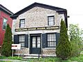
The Howland Cobblestone Store, a historic building in Scipio.
-
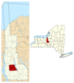
Map showing Scipio within Cayuga County, New York.
See also
 In Spanish: Scipio (Nueva York) para niños
