
Summerhill, New York facts for kids
Quick facts for kids
Summerhill, New York
|
|
|---|---|

Millard Fillmore's birthplace
|
|

Location within Cayuga County and New York
|
|

Summerhill, New York
Location in New York
|
|
| Country | United States |
| State | New York |
| County | Cayuga |
| Government | |
| • Type | Town Council |
| Area | |
| • Total | 25.98 sq mi (67.30 km2) |
| • Land | 25.86 sq mi (66.98 km2) |
| • Water | 0.12 sq mi (0.32 km2) |
| Elevation | 1,660 ft (506 m) |
| Population
(2010)
|
|
| • Total | 1,217 |
| • Estimate
(2016)
|
1,168 |
| • Density | 45.16/sq mi (17.44/km2) |
| Time zone | UTC-5 (Eastern (EST)) |
| • Summer (DST) | UTC-4 (EDT) |
| FIPS code | 36-011-72037 |
| GNIS feature ID | 0979536 |
Summerhill is a small town in Cayuga County, New York, in the United States. In 2010, about 1,217 people lived there. The town got its name from a place in Ireland. You can find Summerhill in the southeast part of Cayuga County, a bit northeast of Ithaca.
Contents
Summerhill's Early History
Before the American Revolution, the land where Summerhill now stands belonged to the Onondaga people. After the war, this area became part of the Central New York Military Tract. This land was set aside for soldiers who had fought in the war. The first European settler arrived in this area around 1797.
How Summerhill Got Its Name
The town was first created in 1831 and was called Plato. It was formed from a part of the town of Locke. However, the name was changed to "Summerhill" in 1832. This was done to avoid confusion with another place that already had the name Plato.
Reforestation Efforts in the 1930s
During the 1930s, a lot of the town's land was replanted with trees. This work was done by the Civilian Conservation Corps. This group was a program during the Great Depression that helped put people to work.
Geography of Summerhill
Summerhill covers about 67.3 square kilometers (25.98 square miles) in total. Most of this area, about 67.0 square kilometers (25.86 square miles), is land. Only a small part, about 0.3 square kilometers (0.12 square miles), is water.
Location and Borders
The southern border of Summerhill touches Tompkins County. The eastern border is next to Cortland County. This means Summerhill is located right at the corner of three different counties.
Main Roads in Summerhill
Two important roads pass through Summerhill. New York State Route 90 runs from east to west in the southern part of the town. New York State Route 41A crosses the northeastern section of Summerhill.
Towns Near Summerhill
Summerhill is surrounded by several other towns:
- To the north is the town of Sempronius.
- To the west is the town of Locke.
- To the south, in Tompkins County, is the town of Groton.
- To the east, in Cortland County, is the town of Homer.
Population and People of Summerhill
| Historical population | |||
|---|---|---|---|
| Census | Pop. | %± | |
| 1840 | 1,446 | — | |
| 1850 | 1,251 | −13.5% | |
| 1860 | 1,194 | −4.6% | |
| 1870 | 1,036 | −13.2% | |
| 1880 | 1,028 | −0.8% | |
| 1890 | 864 | −16.0% | |
| 1900 | 779 | −9.8% | |
| 1910 | 613 | −21.3% | |
| 1920 | 539 | −12.1% | |
| 1930 | 448 | −16.9% | |
| 1940 | 505 | 12.7% | |
| 1950 | 542 | 7.3% | |
| 1960 | 667 | 23.1% | |
| 1970 | 670 | 0.4% | |
| 1980 | 850 | 26.9% | |
| 1990 | 1,017 | 19.6% | |
| 2000 | 1,098 | 8.0% | |
| 2010 | 1,217 | 10.8% | |
| 2016 (est.) | 1,168 | −4.0% | |
| U.S. Decennial Census | |||
In the year 2000, there were 1,098 people living in Summerhill. These people lived in 393 households, and 304 of these were families. The town had about 42 people per square mile.
Most people in Summerhill were White (99.27%). A small number were African American (0.18%) or Native American (0.18%). About 0.36% of the population identified with two or more races. People of Hispanic or Latino background made up 0.64% of the population.
Households and Families
Out of all the households, 37.4% had children under 18 living with them. About 60.3% were married couples living together. Around 7.9% of households had a female head with no husband present. About 22.6% of households were not families.
The average household had 2.79 people. The average family had 3.06 people.
Age Distribution
The population of Summerhill was spread out across different age groups:
- 29.2% were under 18 years old.
- 7.6% were between 18 and 24 years old.
- 30.1% were between 25 and 44 years old.
- 23.8% were between 45 and 64 years old.
- 9.3% were 65 years old or older.
The average age in the town was 36 years. For every 100 females, there were about 105 males.
Income Levels
In 2000, the average income for a household in Summerhill was $39,000 per year. For families, the average income was $39,500. Men earned about $26,336 per year, while women earned about $24,375. The average income per person in the town was $14,609.
About 6.9% of families and 12.1% of all people in Summerhill lived below the poverty line. This included 21.8% of those under 18 and 2.0% of those 65 or older.
Famous People from Summerhill
Summerhill has been home to some notable individuals:
- Millard Fillmore (1800–1874) – He was the 13th President of the United States. He also served as the 12th Vice President. He was the last president from the Whig Party.
- William H. Peters – He was a member of the Wisconsin State Assembly.
- Elbridge G. Spaulding – He was a congressman and also served as the mayor of Buffalo, New York. He was also the treasurer of New York State.
Places and Communities in Summerhill
- Como – This is a small village, also called a hamlet, in the northeastern part of the town. It is located on NY Route 41A.
- Fall Creek – This is a stream that flows south through the eastern part of Summerhill. It eventually joins Cayuga Lake in Ithaca.
- Fillmore Glen State Park – This state park is partly in the northwest of Summerhill and partly in the town of Locke. It has a copy of Millard Fillmore's birthplace.
- Four Town Corners – This is a specific spot in the northwestern corner of the town.
- Halls Corners – This hamlet is on the eastern side of the town, located on NY Route 90, east of the main Summer Hill hamlet.
- Lake Como – This is a small lake located west of the community of Como. It used to be called "Locke Pond."
- Summer Hill – This is the main hamlet of Summer Hill. It is located in the southern part of the town on NY-90.
Images for kids
-
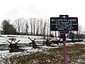
Millard Fillmore's birthplace
-
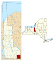
Location within Cayuga County and New York
See also
 In Spanish: Summerhill (Nueva York) para niños
