Locke, New York facts for kids
Quick facts for kids
Locke, New York
|
|
|---|---|

|
|
| Country | United States |
| State | New York |
| County | Cayuga |
| Government | |
| • Type | Town Council |
| Area | |
| • Total | 24.41 sq mi (63.22 km2) |
| • Land | 24.30 sq mi (62.95 km2) |
| • Water | 0.10 sq mi (0.27 km2) |
| Elevation | 1,020 ft (311 m) |
| Population
(2020)
|
|
| • Total | 1,877 |
| • Estimate
(2021)
|
1,888 |
| • Density | 77.84/sq mi (30.06/km2) |
| Time zone | UTC-5 (Eastern (EST)) |
| • Summer (DST) | UTC-4 (EDT) |
| FIPS code | 36-011-43071 |
| GNIS feature ID | 0979163 |
Locke is a town in Cayuga County, New York, in the United States. In 2020, about 1,877 people lived there. The town is named after John Locke, a famous English thinker. It is also the birthplace of Millard Fillmore, who became the 13th President of the United States.
Locke is located on the southern edge of Cayuga County. It is southeast of the city of Auburn.
Contents
History of Locke
Locke is part of a special area called the Central New York Military Tract. This land was given to soldiers who fought in the American Revolutionary War. The first European settlers came to Locke in 1790. They found signs that Native American people had lived there before.
The town of Locke was officially created in 1802. It was formed from a larger town called Genoa, which was then known as "Milton." Over the years, parts of Locke were used to create other towns. In 1817, a part became the town of Groton. Later, in 1831, the town of Summerhill was formed from another part of Locke.
Locke village has experienced two major fires. A big fire in 1912 destroyed about 30 buildings. Another serious fire happened on April 10, 1975. This fire destroyed 11 buildings and caused a lot of damage. It started when a gasoline truck lost its brakes and crashed.
Geography of Locke
The town of Locke covers a total area of about 24.4 square miles (63.2 square kilometers). Most of this area, about 24.3 square miles (63.0 square kilometers), is land. A small part, about 0.1 square miles (0.3 square kilometers), is water.
A main road, New York State Route 38, runs north and south through the town. It crosses another important road, New York State Route 90, in Locke village.
The Owasco Inlet is a stream that flows north through the town. It eventually empties into Owasco Lake. Another stream, Hemlock Creek, joins the Owasco Inlet in Locke village. The town is located in the beautiful Finger Lakes region of New York.
Population and People
| Historical population | |||
|---|---|---|---|
| Census | Pop. | %± | |
| 1820 | 2,559 | — | |
| 1830 | 3,310 | 29.3% | |
| 1840 | 1,654 | −50.0% | |
| 1850 | 1,478 | −10.6% | |
| 1860 | 1,325 | −10.4% | |
| 1870 | 1,077 | −18.7% | |
| 1880 | 1,141 | 5.9% | |
| 1890 | 1,001 | −12.3% | |
| 1900 | 1,079 | 7.8% | |
| 1910 | 864 | −19.9% | |
| 1920 | 770 | −10.9% | |
| 1930 | 714 | −7.3% | |
| 1940 | 748 | 4.8% | |
| 1950 | 811 | 8.4% | |
| 1960 | 982 | 21.1% | |
| 1970 | 1,152 | 17.3% | |
| 1980 | 1,751 | 52.0% | |
| 1990 | 1,917 | 9.5% | |
| 2000 | 1,900 | −0.9% | |
| 2010 | 1,951 | 2.7% | |
| 2020 | 1,877 | −3.8% | |
| 2021 (est.) | 1,888 | −3.2% | |
| U.S. Decennial Census | |||
According to the census from the year 2000, there were 1,900 people living in Locke. These people lived in 704 households, and 539 of these were families. The population density was about 77.9 people per square mile.
About 39.3% of the households had children under 18 living with them. Most households, 58.8%, were married couples living together. About 28.2% of the population was under 18 years old. The average age of people in Locke was 36 years.
Communities and Locations in Locke
- Centerville – This is a historic place located north of Locke village.
- Chipman Corners – A small community, also called a hamlet, in the southeastern part of the town. It is on County Road 161.
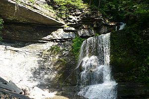
- Fillmore Glen State Park – A state park that is partly located in Locke, near the northern town line.
- Grisamore Farms – A popular place to find fresh fruits like apples, blueberries, and strawberries. They also have pumpkins and plants.
- Locke (formerly "Milan") – This is the main hamlet, or village, in the center of the town. It is where NY-38 and NY-90 roads meet. The Owasco Inlet and Hemlock Creek also join here.
- Satterly Corners – A location north of Shaw Corners on County Road 54.
- Shaw Corners – A location east of Locke village on NY-90.
- Toll Gate Corners – A hamlet located at the northern edge of the town, close to the state park.
See also
 In Spanish: Locke (Nueva York) para niños
 | Janet Taylor Pickett |
 | Synthia Saint James |
 | Howardena Pindell |
 | Faith Ringgold |


