
Cato (village), New York facts for kids
Quick facts for kids
Cato, New York
|
|
|---|---|

Cato (village), New York
Location in New York
|
|
| Country | United States |
| State | New York |
| County | Cayuga |
| Town | Cato |
| Area | |
| • Total | 1.01 sq mi (2.62 km2) |
| • Land | 0.99 sq mi (2.56 km2) |
| • Water | 0.03 sq mi (0.06 km2) |
| Elevation | 459 ft (140 m) |
| Population
(2020)
|
|
| • Total | 517 |
| • Density | 522.75/sq mi (201.93/km2) |
| Time zone | UTC-5 (Eastern (EST)) |
| • Summer (DST) | UTC-4 (EDT) |
| ZIP code |
13033
|
| Area code(s) | 315 |
| FIPS code | 36-12958 |
| GNIS feature ID | 0946053 |
Cato is a small village located in Cayuga County, New York. In 2020, about 517 people lived there. The village's name comes from the Central New York Military Tract, where many places were given classical names. Cato village is split between two nearby towns: the town of Cato and the town of Ira. It is situated to the west of the city of Syracuse.
Contents
History of Cato Village
Early Settlers and Beginnings
The land where Cato is located was part of the Central New York Military Tract. This land was set aside in 1782 for soldiers who fought in the American Revolution. Before this, Native American communities lived in the area. The first permanent settler arrived around 1805. The new community was first known as "Jakway's Corners."
Railroad and Modern Life
In 1869, a railroad line reached Cato. This helped the village grow and become more successful. However, train service eventually stopped in 1953. Today, many people who live in Cato travel to work in bigger cities nearby. This makes Cato a "bedroom community." The village is also proud of its 1993 Section 3 Class D state football champions.
Geography of Cato
Village Area and Water
According to the United States Census Bureau, the village of Cato covers about 1.01 square miles (2.6 square kilometers). A small part of this area, about 0.02 square miles (0.06 square kilometers), is water.
Natural Features
Cato is located in an area with many drumlins. These are small, oval-shaped hills formed by glaciers. A small lake called Parker Pond, once known as "Forest Lake," is found at the southeast edge of the village. Water from Muskrat Creek flows out of Parker Pond and goes south towards the Seneca River. The Seneca River is also part of the Erie Canal.
Roads and Travel
The village is easy to get around because it sits at the meeting point of two main roads: NY-34 and NY-370. Most places you might want to visit in Cato are located along these two highways.
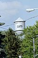
Cato's Water Tower
The Cato water tower is a tall structure that stands 120 feet (37 meters) above the village. It is located northeast of the village center. For over 75 years, the light blue tower was a well-known landmark. In June 2012, the old tower was taken down. A new, dark blue water tower was built in its place. The new tower is 82 feet (25 meters) tall and holds 25,000 more gallons of water. This extra capacity is ready for the village's future growth.
Population Information
| Historical population | |||
|---|---|---|---|
| Census | Pop. | %± | |
| 1880 | 313 | — | |
| 1900 | 350 | — | |
| 1910 | 374 | 6.9% | |
| 1920 | 404 | 8.0% | |
| 1930 | 403 | −0.2% | |
| 1940 | 412 | 2.2% | |
| 1950 | 431 | 4.6% | |
| 1960 | 476 | 10.4% | |
| 1970 | 601 | 26.3% | |
| 1980 | 475 | −21.0% | |
| 1990 | 581 | 22.3% | |
| 2000 | 601 | 3.4% | |
| 2010 | 532 | −11.5% | |
| 2020 | 517 | −2.8% | |
| U.S. Decennial Census | |||
In 2000, there were 601 people living in Cato. These people lived in 238 households, with 154 of them being families. The village had about 608 people per square mile. Most residents (97.50%) were White. A small number of people were African American, Native American, or from other backgrounds. About 0.50% of the population was Hispanic or Latino.
Households and Families
Out of the 238 households, about 35% had children under 18 living there. More than half (51.3%) were married couples. About 11% of households had a female head with no husband present. The average household had 2.53 people, and the average family had 3.15 people.
Age and Income
The population of Cato was spread out by age. About 29.5% of residents were under 18 years old. About 17.1% were 65 years or older. The average age in the village was 38 years.
In 2000, the average income for a household in Cato was $35,938. For families, the average income was $49,219. About 6.9% of all people in the village lived below the poverty line. This included 5.5% of those under 18 and 21.0% of those 65 or older.
Images for kids
-
Old Cato water tower
Summer 2012 -

New Water Tower Winter 2017


See Also
 In Spanish: Cato (villa) para niños
