Sterling, New York facts for kids
Quick facts for kids
Sterling, New York
|
|
|---|---|

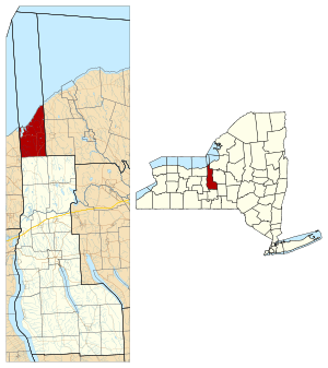
Location in Cayuga County and New York
|
|
| Country | United States |
| State | New York |
| County | Cayuga |
| Government | |
| • Type | Town Council |
| Area | |
| • Total | 47.11 sq mi (122.02 km2) |
| • Land | 45.44 sq mi (117.69 km2) |
| • Water | 1.67 sq mi (4.33 km2) |
| Elevation | 344 ft (105 m) |
| Population
(2010)
|
|
| • Total | 3,040 |
| • Estimate
(2016)
|
3,006 |
| • Density | 66.15/sq mi (25.54/km2) |
| Time zone | UTC-5 (Eastern (EST)) |
| • Summer (DST) | UTC-4 (EDT) |
| ZIP code |
13156
|
| Area code(s) | 315 |
| FIPS code | 36-011-71146 |
| GNIS feature ID | 0979524 |
Sterling is a small town in Cayuga County, New York, United States. In 2010, about 3,040 people lived there. The town is located right on the shore of Lake Ontario. It was named after William Alexander, Lord Stirling, who was an American general during the Revolutionary War. Sterling is the northernmost town in Cayuga County and is located northwest of Syracuse.
Contents
Exploring Sterling's Past
Early History and First Settlers
Long ago, this area was part of the land belonging to the Onondaga. They were one of the original Five Nations of the Iroquois Confederacy. After the Revolutionary War, the Onondaga, who had sided with the British, had to give up most of their lands in New York.
This land became part of the Central New York Military Tract. This tract was divided into plots and given to soldiers who fought in the Revolutionary War as payment. The first European-American settler, Pierre Dumas, arrived in Sterling in 1805. The Town of Sterling was officially formed in 1812. It was created from a larger area called the Town of Cato.
Growth and Local Attractions
In the early 1800s, improvements were made to Little Sodus Bay on Lake Ontario. This helped Sterling become a port town. It allowed the town to take part in trade across the Great Lakes. However, as transportation changed and cities in the west grew, the port became less important for business.
Today, Sterling is a popular spot for vacations and fun activities. One of its biggest attractions is the Sterling Renaissance Festival. This festival happens every summer and has been attracting visitors for over forty years. It's like stepping back in time to a medieval fair!
Two important historical buildings in Sterling are the Sterling District No. 5 Schoolhouse and the Sterling Grist Mill Complex. Both of these places were added to the National Register of Historic Places in 1985. This means they are recognized as important historical sites.
Geography of Sterling
Size and Location
According to the United States Census Bureau, the town of Sterling covers a total area of about 122 square kilometers (47.1 square miles). Most of this area, about 117.7 square kilometers (45.4 square miles), is land. The rest, about 4.3 square kilometers (1.7 square miles), is water.
Sterling's northern border is Lake Ontario, one of the huge Great Lakes. Sterling is special because it's the only town in Cayuga County that has direct access to the Great Lakes.
Major Roads and Routes
Several important roads pass through Sterling. New York State Route 3 starts here, and New York State Route 38 also ends in the town. New York State Route 104 crosses the southern part of Sterling. Another road, New York State Route 104A, goes across the northern part of the town. These roads help people travel in and out of Sterling.
People and Population
| Historical population | |||
|---|---|---|---|
| Census | Pop. | %± | |
| 1820 | 792 | — | |
| 1830 | 1,436 | 81.3% | |
| 1840 | 2,533 | 76.4% | |
| 1850 | 2,808 | 10.9% | |
| 1860 | 3,008 | 7.1% | |
| 1870 | 2,840 | −5.6% | |
| 1880 | 3,034 | 6.8% | |
| 1890 | 2,959 | −2.5% | |
| 1900 | 2,516 | −15.0% | |
| 1910 | 2,359 | −6.2% | |
| 1920 | 2,039 | −13.6% | |
| 1930 | 1,966 | −3.6% | |
| 1940 | 1,943 | −1.2% | |
| 1950 | 2,050 | 5.5% | |
| 1960 | 2,495 | 21.7% | |
| 1970 | 2,589 | 3.8% | |
| 1980 | 3,301 | 27.5% | |
| 1990 | 3,285 | −0.5% | |
| 2000 | 3,432 | 4.5% | |
| 2010 | 3,040 | −11.4% | |
| 2016 (est.) | 3,006 | −1.1% | |
| U.S. Decennial Census | |||
In 2000, there were 3,432 people living in Sterling. These people lived in 1,337 households, and 962 of those were families. The population density was about 75 people per square mile. There were also 1,922 housing units in the town.
Most of the people in Sterling were White (98.46%). A small number were African American, Native American, or Asian. Some people were from other races or from two or more races. About 0.50% of the population was Hispanic or Latino.
About 31.6% of households had children under 18 living with them. Most households (58.0%) were married couples living together. About 22.1% of all households were made up of people living alone.
The average household had 2.56 people, and the average family had 2.99 people. The population was spread out by age. About 26.5% were under 18 years old. About 6.1% were between 18 and 24. And 13.6% were 65 years or older. The average age in Sterling was 38 years.
Communities and Places in Sterling
Sterling is home to several smaller communities and interesting spots:
- Crocketts (also called "Sterling Valley Station") – This is a small community, or hamlet, near the eastern border of the town. You can find it where Route 104A and Route 3 meet.
- Fair Haven – This is a village located in the northern part of Sterling.
- Fair Haven Beach State Park – A fun state park located just north of Fair Haven.
- Fintches Corners – A hamlet located right in the middle of the town, along NY Route 38.
- Little Sodus Bay – This is a bay on Lake Ontario, located north of Fair Haven. It's called "Little Sodus Bay" to tell it apart from a larger bay called Sodus Bay to the west.
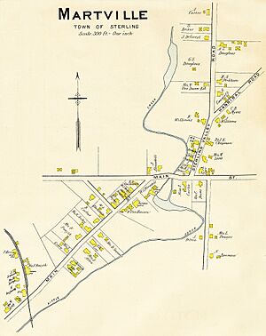
- Martville – A place near the eastern town line, found on NY State Route 104.
- McKnight Corners – A location northeast of North Fair Haven.
- Moon Beach – A small community right on the shore of Lake Ontario, in the northeastern part of the town.
- Nine Mile Creek – A stream that flows into Lake Ontario in the northeastern part of Sterling.
- North Fair Haven – A spot in the northeastern part of the village of Fair Haven, on the east side of Little Sodus Bay.
- North Sterling – A hamlet northeast of Fair Haven, located on NY-104A.
- North Victory – A hamlet near the southern town line, where Route 104 and Route 38 cross.
- The Pond – A small lake inside Fair Haven State Park. It's separated from Lake Ontario by a narrow strip of land.
- Sterling – This is a hamlet, also known as "Sterling Center," located east of Fair Haven and on NY-38.
- Sterling Creek – A stream that flows into The Pond.
- Sterling Valley – A hamlet northeast of Fair Haven village, located on Route NY-104A.
- West Nine Mile Point – A piece of land that sticks out into Lake Ontario, northeast of Fair Haven.
- Whiting Corners – A location in the southwestern part of the town.
See also
 In Spanish: Sterling (Nueva York) para niños
 | Victor J. Glover |
 | Yvonne Cagle |
 | Jeanette Epps |
 | Bernard A. Harris Jr. |


