
Williamson, New York facts for kids
Quick facts for kids
Williamson, New York
|
||
|---|---|---|

Williamson looking north on South Avenue (NY 21)
|
||
|
||
| Nickname(s):
Pound Town
|
||
| Motto(s):
You're either working hard, or you're hard at work
|
||

Location in Wayne County and the state of New York.
|
||

Williamson, New York
Location in New York
|
||
| Country | United States | |
| State | New York | |
| County | Wayne | |
| Settled | 1794 | |
| Established | February 20, 1802 | |
| Government | ||
| • Type | Town Council | |
| Area | ||
| • Total | 34.66 sq mi (89.76 km2) | |
| • Land | 34.64 sq mi (89.72 km2) | |
| • Water | 0.01 sq mi (0.04 km2) 0.06% | |
| Elevation | 480-450 ft (146-115 m) | |
| Population
(2010)
|
||
| • Total | 6,984 | |
| • Estimate
(2016)
|
6,778 | |
| • Density | 195.67/sq mi (75.55/km2) | |
| Time zone | UTC-5 (Eastern (EST)) | |
| • Summer (DST) | UTC-4 (EDT) | |
| ZIP code |
14589
|
|
| Area code(s) | 315 and 680 | |
| FIPS code | 36-82040 | |
| GNIS feature ID | 0979640 | |
| Website | http://www.town.williamson.ny.us | |

Williamson is a town located on the south shore of Lake Ontario. It is in the northwest part of Wayne County, New York, United States. In 2010, the town had a population of 6,984 people.
The town is named after Charles Williamson, who was a land agent for the Pulteney Estate. The main ZIP code for Williamson is 14589. The town also includes a hamlet (a small community) that is also called Williamson. The main government offices for the town are located in this hamlet.
Contents
History of Williamson
Early Settlement and Land Deals
The area around Pultneyville was a common meeting place for the Iroquois people. Pultneyville is a small community on the town's Lake Ontario shore. In 1788, this land became part of the Phelps and Gorham Purchase. This was a huge area of land, about 6 million acres (24,000 km²), sold to Oliver Phelps and Nathaniel Gorham.
The first white settler, Daniel Russell, built a log cabin in Pultneyville in 1794. Pultneyville was an important port in the area for a short time. However, its importance changed when the Erie Canal opened in 1823. Even so, it remained a key port on the Great Lakes for many years.
How Williamson Town Was Formed
Williamson was created in 1802 from the Town of Sodus. It was much larger back then. Over time, other towns were formed from parts of Williamson. These include Ontario in 1807 and Marion in 1825.
Williamson During the War of 1812
In 1814, during the War of 1812, British troops landed in Pultneyville. They made a deal with the villagers to take some supplies without a fight. But a disagreement started, and fighting broke out. Some citizens were hurt or killed, and two were captured before the British left.
Celebrating Williamson's History
In 2002, Williamson celebrated its 200th birthday. There were many celebrations and festivals throughout the year to mark this special event.
Geography of Williamson
Size and Location
According to the United States Census Bureau, Williamson has a total area of about 34.7 square miles (89.7 km²). Most of this area is land, with only a small part being water.
Williamson includes the communities of Williamson, Pultneyville, and East Williamson. The closest large city is Rochester, which is to the west. The town of Williamson does not have an official village within its borders.
Roads and Highways
In 1980, the northern end of New York State Route 21 (NY 21) was moved. It now ends at NY 104 in Williamson. This is about 0.7 miles (1.1 km) north of the town's main business area.
NY 104 is a major highway that runs east and west in western New York. NY 21 is a north-south highway. Many people use NY 21 to get to the New York State Thruway (Interstate 90).
Neighboring Areas
Williamson is bordered by Lake Ontario to the north. To the east is the Town of Sodus. The Town of Marion is to the south, and the Town of Ontario is to the west.
Landmarks and Events in Williamson
Popular Eateries

Williamson has several popular places that are well-known to both locals and visitors.
- Orbaker's Drive-In: This hamburger and hotdog stand on NY 104 has been open since 1932. It is famous for its red and white colors. Working there in the summer is a common experience for teenagers in town.
- The Candy Kitchen: Located on West Main Street, this eatery opened in 1890. It is known as "Nick's" and has been run by four generations of the Boosalis family. Their chocolate candies, Greek dishes, and fountain drinks are very popular.
Williamson Apple Blossom Festival
Since 1960, Williamson has hosted the annual Williamson Apple Blossom Festival. This event celebrates the town's history of apple farming. It takes place in May when the apple trees are in full bloom. The week-long festival starts with choosing a local festival queen. It ends with a carnival, a popular 5k race, a parade, and a "fly-in" breakfast at the local airport.
Economy of Williamson
Williamson is mostly a rural town focused on agriculture. However, since the 1960s, it has also become a "bedroom community" for people working at companies in Rochester. These companies include Xerox and Eastman Kodak.
The town is well-known for its fruit growing, especially apples, peaches, and cherries. Dairy farming is also an important part of the local agriculture. Williamson is home to a Mott's plant, which employs about 300 people.
Population and People
| Historical population | |||
|---|---|---|---|
| Census | Pop. | %± | |
| 1820 | 2,521 | — | |
| 1830 | 1,788 | −29.1% | |
| 1840 | 2,147 | 20.1% | |
| 1850 | 2,380 | 10.9% | |
| 1860 | 2,681 | 12.6% | |
| 1870 | 2,430 | −9.4% | |
| 1880 | 2,745 | 13.0% | |
| 1890 | 2,670 | −2.7% | |
| 1900 | 2,670 | 0.0% | |
| 1910 | 3,060 | 14.6% | |
| 1920 | 3,293 | 7.6% | |
| 1930 | 3,504 | 6.4% | |
| 1940 | 3,700 | 5.6% | |
| 1950 | 4,226 | 14.2% | |
| 1960 | 5,294 | 25.3% | |
| 1970 | 6,356 | 20.1% | |
| 1980 | 6,319 | −0.6% | |
| 1990 | 6,540 | 3.5% | |
| 2000 | 6,777 | 3.6% | |
| 2010 | 6,984 | 3.1% | |
| 2016 (est.) | 6,969 | −0.2% | |
| U.S. Decennial Census | |||
In 2010, there were 6,984 people living in Williamson. There were 2,773 households and 1,980 families. The population density was about 201 people per square mile (77.7 people per km²).
Most of the people in Williamson are White (92.4%). Other groups include Black or African American (3.3%), Native American (0.4%), and Asian (0.4%). About 3.9% of the population was Hispanic or Latino.
Age and Households
The population in Williamson is spread out by age:
- 25.7% were under 20 years old.
- 4.3% were from 20 to 24.
- 23.1% were from 25 to 44.
- 31.4% were from 45 to 64.
- 16.0% were 65 years or older.
The average age in Williamson was 43.1 years. For every 100 females, there were 100 males.
Most households (56.9%) were married couples living together. About 28.1% of households had children under 18. The average household size was 2.51 people, and the average family size was 2.94 people.
Income and Housing
The average income for a household in Williamson was $57,804. For a family, the average income was $67,184. The average income per person in the town was $30,651. About 5.7% of families and 11.1% of the total population lived below the poverty line.
There were 3,121 housing units in the town. Most of these (80.4%) were lived in by their owners, while 19.6% were rented.
Local Rules on Sales of Certain Beverages
On January 16, 1920, Williamson, like the rest of the United States, became "dry." This meant that the sale of certain beverages was not allowed due to the Eighteenth Amendment.
However, when the Twenty-first Amendment ended this rule for most of the country in 1933, Williamson kept some of its own rules. While people could have these beverages in their homes, selling them in the town was still not allowed. This continued for more than 60 years, until 1996.
Changes to Local Rules
In 1996, the people of Williamson voted to change these rules. After this vote, stores in town were allowed to sell wine coolers and beer. Before this change, residents had to buy these drinks in nearby towns like Sodus and Ontario.
Later, in 2004, voters again decided to loosen the rules. This allowed restaurants to serve these beverages. It also permitted winery licenses for farms and the opening of liquor stores. Places like bars and taverns were not allowed until 2004. Today, the town only bans the sale of beer at race tracks, outdoor sports fields, and stadiums where people pay to enter.
Communities and Locations in Williamson
- East Williamson – A small community near the eastern town line on Ridge Road (County Route 103).
- Pultneyville – A community on the shore of Lake Ontario. It is located where CR 101 and CR 120 meet. It was once an important port. The community is named after Sir William Pulteney, an early investor in Western New York land.
- Salmon Creek – A stream that flows north into Lake Ontario through Pultneyville.
- Haldoville – A small group of cottages and animal kennels along the shore of Lake Ontario.
- Williamson – This is the main community (hamlet) of Williamson. It is located on Ridge Road near the center of the town.
- Williamson–Sodus Airport – A small airport that serves the town and nearby areas. It is just east of the town line in Sodus, south of NY 104.
Images for kids
-
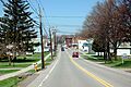
Williamson looking north on South Avenue (NY 21)
-

Seal of Williamson, New York
-
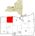
Location in Wayne County and New York State
-
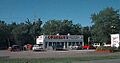
Orbaker's Drive-In
See also
 In Spanish: Williamson (Nueva York) para niños
