Rose, New York facts for kids
Quick facts for kids
Rose, New York
|
|
|---|---|

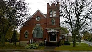
Rose Town Hall
|
|

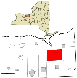
Location in Wayne County and the state of New York.
|
|
| Country | United States |
| State | New York |
| County | Wayne |
| Settled | 1805 |
| Established | February 5, 1826 |
| Government | |
| • Type | Town Board |
| Area | |
| • Total | 33.90 sq mi (87.81 km2) |
| • Land | 33.90 sq mi (87.79 km2) |
| • Water | 0.01 sq mi (0.02 km2) |
| Elevation | 400 ft (122 m) |
| Population
(2010)
|
|
| • Total | 2,369 |
| • Estimate
(2016)
|
2,292 |
| • Density | 67.62/sq mi (26.11/km2) |
| Time zone | UTC-5 (Eastern (EST)) |
| • Summer (DST) | UTC-4 (EDT) |
| ZIP code |
14516 (North Rose)
14542 (Rose) |
| Area code(s) | 315 |
| FIPS code | 36-63605 |
| GNIS feature ID | 0979433 |
| Website | www.townofrose.com |
Rose is a small town located in Wayne County, New York, in the United States. In 2010, about 2,369 people lived there. The town was named after Robert S. Rose, who was an important landowner in the area a long time ago.
The Town of Rose is in the middle of Wayne County. It is located west of the city of Syracuse, New York.
There are two post offices in the Town of Rose. However, the area uses four different postal codes. Most addresses in the northern part of Rose use the ZIP Code 14516 for North Rose. The main area of the hamlet of Rose uses the ZIP Code 14542. Much of the southern part of the town uses ZIP Codes 14433 for Clyde or 14489 for Lyons.
The town's government offices are located in North Rose.
Contents
History of Rose
The first people started settling in the area around 1805.
How Rose Became a Town
The Town of Rose was officially created in 1826. It was formed from a part of the Town of Wolcott.
The Gold Treasure Story
Around 1840, something strange happened in Rose. Many local people started to believe that a treasure of gold and jewels was buried somewhere in the town. People secretly dug for it at night, but they never found anything.
Geography of Rose
According to the United States Census Bureau, the town covers a total area of about 33.9 square miles (87.8 square kilometers). Almost all of this area is land, with only a tiny bit being water.
Roads and Rivers
New York State Route 414 is a main highway that runs north and south through the town.
Sodus Creek is a stream that flows northward through Rose. It eventually reaches Sodus Bay.
Population and People
| Historical population | |||
|---|---|---|---|
| Census | Pop. | %± | |
| 1830 | 1,641 | — | |
| 1840 | 2,038 | 24.2% | |
| 1850 | 2,264 | 11.1% | |
| 1860 | 2,119 | −6.4% | |
| 1870 | 2,056 | −3.0% | |
| 1880 | 2,244 | 9.1% | |
| 1890 | 2,107 | −6.1% | |
| 1900 | 2,055 | −2.5% | |
| 1910 | 1,883 | −8.4% | |
| 1920 | 1,928 | 2.4% | |
| 1930 | 1,921 | −0.4% | |
| 1940 | 1,882 | −2.0% | |
| 1950 | 2,013 | 7.0% | |
| 1960 | 2,122 | 5.4% | |
| 1970 | 2,356 | 11.0% | |
| 1980 | 2,684 | 13.9% | |
| 1990 | 2,424 | −9.7% | |
| 2000 | 2,442 | 0.7% | |
| 2010 | 2,369 | −3.0% | |
| 2016 (est.) | 2,292 | −3.3% | |
| U.S. Decennial Census | |||
In 2010, there were 2,369 people living in Rose. These people made up 904 households and 646 families. The town had about 70 people per square mile (27 people per square kilometer).
Most people in Rose are White (95.4%). A smaller number are Black (0.5%), Native American (0.5%), or Asian (0.2%). About 3.3% of the population identified as Hispanic or Latino.
Households and Families
- About 27.7% of households had children under 18 living with them.
- 56.0% of households were married couples living together.
- The average household had 2.61 people, and the average family had 3.02 people.
Age Distribution
The population of Rose is spread out by age:
- 25.4% were under 20 years old.
- 6.0% were between 20 and 24.
- 21.5% were between 25 and 44.
- 30.6% were between 45 and 64.
- 16.6% were 65 years old or older.
The average age in Rose was 43.4 years.
Income and Poverty
The average income for a household in Rose was about $52,984. For families, the average income was about $58,060. About 8.7% of all people in Rose lived below the poverty line. This included 13.1% of those under 18 and 4.7% of those 65 or older.
Communities and Locations in Rose
Here are some of the smaller communities and important places within the Town of Rose:
- Glenmark (also known as "Glenmark Falls") — This is a small hamlet located near the northern border of the town, northwest of North Rose.
- Lockwood Corners — You can find this spot in the eastern part of the town, south of Stewart Corners on County Road 253.
- Maunders Corners — This location is south of the main Rose village on NY-414.
- North Rose (once called "Lambs Corners") — This hamlet is north of the main Rose village on NY-414. It grew more than the Rose village because it had a railroad station.
- Rose (formerly "Valentine," "Albion," and "Rose Valley") — This is the main hamlet of Rose, located on NY-414. It was first settled around 1811.
- Rose Center — This was a location in the town in the past.
- Stewart Corners — This spot is near the eastern border of the town on County Road 259.
- Wayne Center — This hamlet is near the western border of the town on County Road 251. Its name comes from being close to the center of Wayne County.
See also
 In Spanish: Rose (Nueva York) para niños
 | Selma Burke |
 | Pauline Powell Burns |
 | Frederick J. Brown |
 | Robert Blackburn |


