Solon, New York facts for kids
Quick facts for kids
Solon, New York
|
|
|---|---|

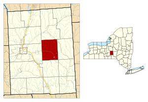
Location within Cortland County and New York
|
|
| Country | United States |
| State | New York |
| County | Cortland |
| Government | |
| • Type | Town Council |
| Area | |
| • Total | 29.73 sq mi (76.99 km2) |
| • Land | 29.65 sq mi (76.80 km2) |
| • Water | 0.08 sq mi (0.20 km2) |
| Elevation | 1,371 ft (418 m) |
| Population
(2010)
|
|
| • Total | 1,079 |
| • Estimate
(2016)
|
1,061 |
| • Density | 35.78/sq mi (13.82/km2) |
| Time zone | UTC-5 (Eastern (EST)) |
| • Summer (DST) | UTC-4 (EDT) |
| FIPS code | 36-023-68264 |
| GNIS feature ID | 0979502 |
Solon is a small town located in Cortland County, New York, in the United States. In 2010, about 1,079 people lived there. The town was named after Solon, a famous lawmaker from ancient Greece.
Solon is in the middle of Cortland County. It is located east of the city of Cortland.
History of Solon
The land where Solon is today was once part of the Central New York Military Tract. This was land given to soldiers who fought in the American Revolution as payment. The first settlers arrived in Solon in 1794.
The town of Solon was officially created in 1798. It was formed from a part of the town of Homer. This happened before Cortland County was even formed. Later, Solon lost some of its land to other towns. These towns were Truxton in 1811 and Taylor in 1849.
The number of people living in Solon grew a lot in the early years. The population reached its highest point in 1840 with 2,311 residents. However, by 1865, the population had gone down to 995 people.
A special old building called the Hatheway Homestead is in Solon. It was added to the National Register of Historic Places in 1978. This means it is an important historical site.
Geography of Solon
The United States Census Bureau collects information about places. According to them, the town of Solon covers about 77.0 square kilometers (29.7 square miles) in total. Most of this area, about 76.8 square kilometers (29.65 square miles), is land. Only a small part, about 0.2 square kilometers (0.08 square miles), is water.
New York State Route 41 is a main road that goes through the town. It runs from east to west.
Solon's Population
| Historical population | |||
|---|---|---|---|
| Census | Pop. | %± | |
| 1820 | 1,262 | — | |
| 1830 | 2,033 | 61.1% | |
| 1840 | 2,426 | 19.3% | |
| 1850 | 1,057 | −56.4% | |
| 1860 | 1,148 | 8.6% | |
| 1870 | 872 | −24.0% | |
| 1880 | 842 | −3.4% | |
| 1890 | 687 | −18.4% | |
| 1900 | 622 | −9.5% | |
| 1910 | 518 | −16.7% | |
| 1920 | 498 | −3.9% | |
| 1930 | 483 | −3.0% | |
| 1940 | 486 | 0.6% | |
| 1950 | 522 | 7.4% | |
| 1960 | 549 | 5.2% | |
| 1970 | 687 | 25.1% | |
| 1980 | 865 | 25.9% | |
| 1990 | 1,008 | 16.5% | |
| 2000 | 1,108 | 9.9% | |
| 2010 | 1,079 | −2.6% | |
| 2016 (est.) | 1,061 | −1.7% | |
| U.S. Decennial Census | |||
In the year 2000, there were 1,108 people living in Solon. These people lived in 382 different homes. About 310 of these homes were families. On average, there were about 2.9 people living in each home.
Many homes in Solon had children under 18 living there. About 43.7% of homes had kids. Most homes, about 64.9%, were married couples living together.
The people in Solon were of different ages. About 30.4% of the population was under 18 years old. About 33.7% were between 25 and 44 years old. The average age of people in Solon was 35 years.
Places in Solon
- Mayberry Brook — This is a small stream. It is located near the western edge of the town. It flows into Trout Brook.
- Mayberry Mills — This is a small village or settlement. It is located at the western border of the town.
- Solon — This is the main village or hamlet of Solon. It is located right on NY Route 41.
- Trout Brook — This is a stream that flows into the Tioughnioga River. Trout Brook flows towards the west from the town.
See also
 In Spanish: Solon (Nueva York) para niños
 | Anna J. Cooper |
 | Mary McLeod Bethune |
 | Lillie Mae Bradford |


