Mattydale, New York facts for kids
Quick facts for kids
Mattydale, New York
|
|
|---|---|

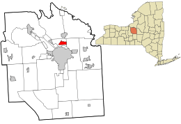
Location in Onondaga County and the state of New York.
|
|
| Country | United States |
| State | New York |
| County | Onondaga |
| Area | |
| • Total | 1.92 sq mi (4.97 km2) |
| • Land | 1.92 sq mi (4.97 km2) |
| • Water | 0.00 sq mi (0.00 km2) |
| Elevation | 404 ft (123 m) |
| Population
(2020)
|
|
| • Total | 6,296 |
| • Density | 3,279.17/sq mi (1,265.78/km2) |
| Time zone | UTC-5 (Eastern (EST)) |
| • Summer (DST) | UTC-4 (EDT) |
| ZIP code |
13211
|
| Area code(s) | 315 |
| FIPS code | 36-46151 |
| GNIS feature ID | 0956687 |
Mattydale is a community in Onondaga County, New York, United States. It is known as a hamlet and a census-designated place. In 2010, about 6,446 people lived there.
Mattydale is located in the northeast part of the town of Salina. It is a northern suburb of the city of Syracuse. The community was named after the farm of Frank Matty, one of its early residents.
Did you know that a famous author spent time here? L. Frank Baum, who wrote The Wonderful Wizard of Oz, spent much of his childhood in the Mattydale area. He was born nearby in Chittenango. Later, he lived on the site of what was once a roller rink. Some people think the yellowish wood of an old plank road in the area might have inspired the famous Yellow brick road in his books!
Contents
Exploring Mattydale's Location
Mattydale is found at coordinates 43.098717 degrees north and -76.143530 degrees west. It is located just north of the city of Syracuse.
Land and Water Around Mattydale
According to the United States Census Bureau, Mattydale covers an area of about 1.9 square miles (4.9 square kilometers). All of this area is land. There are no large bodies of water within the community itself.
Major Roads and Nearby Places
The New York State Thruway (Interstate 90) runs through Mattydale. This major highway connects with Interstate 81 just west of the community. Mattydale is also southwest of the Syracuse Hancock International Airport. It shares a border with the community of Hinsdale.
A small stream called Ley Creek flows along the southern part of Mattydale. This creek eventually empties into Onondaga Lake, which is a few miles southwest of the community.
Mattydale's Population and People
| Historical population | |||
|---|---|---|---|
| Census | Pop. | %± | |
| 2020 | 6,296 | — | |
| U.S. Decennial Census | |||
In 2000, there were about 6,367 people living in Mattydale. These people lived in 2,631 households, with 1,673 of these being families. The community had about 3,323 people per square mile (1,283 people per square kilometer).
Who Lives in Mattydale?
Many different people live in Mattydale. In 2000, about 29.8% of households had children under 18 living with them. About 42.5% of households were married couples. The average household had 2.42 people, and the average family had 2.99 people.
The population of Mattydale is made up of people of all ages. In 2000, about 25.4% of the people were under 18 years old. About 16.5% were 65 years old or older. The average age of people in Mattydale was 37 years.
See also
 In Spanish: Mattydale para niños
 | Bayard Rustin |
 | Jeannette Carter |
 | Jeremiah A. Brown |

