Spafford, New York facts for kids
Quick facts for kids
Spafford, New York
|
|
|---|---|

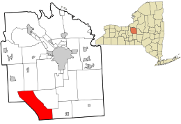
Location in Onondaga County and the state of New York.
|
|
| Country | United States |
| State | New York |
| County | Onondaga |
| Government | |
| • Type | Town Council |
| Area | |
| • Total | 39.22 sq mi (101.57 km2) |
| • Land | 32.70 sq mi (84.69 km2) |
| • Water | 6.52 sq mi (16.88 km2) |
| Elevation | 1,490 ft (454 m) |
| Population
(2020)
|
|
| • Total | 1,588 |
| • Density | 40.490/sq mi (15.635/km2) |
| Time zone | UTC-5 (Eastern (EST)) |
| • Summer (DST) | UTC-4 (EDT) |
| FIPS code | 36-70057 |
| GNIS feature ID | 0979511 |
Spafford is a small town located in Onondaga County, New York, in the United States. In 2020, about 1,588 people lived there. The town gets its name from Horatio Gates Spafford, who was a writer and helped start the local library. Spafford is in the southwestern part of Onondaga County, southwest of the city of Syracuse.
Contents
A Look Back: Spafford's History
Spafford is part of what used to be called the Central New York Military Tract. This area was set aside for soldiers after the American Revolutionary War.
The first European settler arrived in Spafford in 1794. This was the same year that Onondaga County was officially created.
The Town of Spafford was formed in 1811. It was created from parts of three other towns: Marcellus, Sempronius, and Tully.
Exploring Spafford's Geography
Spafford covers a total area of about 39.2 square miles (101.57 square kilometers). Most of this area, about 32.8 square miles (84.69 square kilometers), is land. The rest, about 6.4 square miles (16.88 square kilometers), is water.
The western edge of Spafford borders Cayuga County. The southern edge borders Cortland County. A special feature of the town is that it sits between two of the famous Finger Lakes: Skaneateles Lake and Otisco Lake.
Natural Beauty and Roads
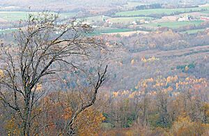
Spafford is known for its high land, which offers amazing views, especially because it's located between two of the Finger Lakes. The town is mostly rural, meaning it has lots of open spaces and farms rather than big cities. It has many forested areas, and some of these are protected as public preserves for everyone to enjoy.
Two main highways run through the town. New York State Route 41 goes from north to south. New York State Route 174 is a state highway found in the northern part of Spafford.
Spafford's Population Over Time
| Historical population | |||
|---|---|---|---|
| Census | Pop. | %± | |
| 1820 | 1,294 | — | |
| 1830 | 2,647 | 104.6% | |
| 1840 | 1,873 | −29.2% | |
| 1850 | 1,903 | 1.6% | |
| 1860 | 1,814 | −4.7% | |
| 1870 | 1,595 | −12.1% | |
| 1880 | 1,450 | −9.1% | |
| 1890 | 1,227 | −15.4% | |
| 1900 | 1,159 | −5.5% | |
| 1910 | 1,064 | −8.2% | |
| 1920 | 875 | −17.8% | |
| 1930 | 767 | −12.3% | |
| 1940 | 742 | −3.3% | |
| 1950 | 829 | 11.7% | |
| 1960 | 974 | 17.5% | |
| 1970 | 1,148 | 17.9% | |
| 1980 | 1,596 | 39.0% | |
| 1990 | 1,675 | 4.9% | |
| 2000 | 1,661 | −0.8% | |
| 2010 | 1,686 | 1.5% | |
| 2020 | 1,588 | −5.8% | |
| U.S. Decennial Census | |||
Even though Spafford is in a quiet corner of Onondaga County and is somewhat separated by the Finger Lakes, more homes are being built there. This growth is coming from the nearby town of Skaneateles.
In the year 2000, there were 1,661 people living in Spafford. The average number of people living in each home was about 2.63. The average family size was about 2.97 people.
The population was spread out by age. About 25.5% of the people were under 18 years old. About 11.0% were 65 years or older. The average age in the town was 41 years old.
Communities and Places in Spafford
Spafford has several small communities and interesting spots:
- Borodino – This is the largest hamlet (a small village) in Spafford. It's about eight miles south of the Village of Skaneateles.
- Borodino Landing – A small community located west of Borodino. You can find it on the shore of Skaneateles Lake, south of Woodland.
- Edgewater Park – A small community around Five Mile Point on the eastern side of Skaneateles Lake. It's located on NY-41 in the northeastern part of the town.
- Gifford Hill – A high point (elevation) near the southern border of the town, south of South Spafford.
- Jenny Point – A spot on the lake shore, just north of Willow Point.
- Pine Grove – A hamlet on the shore of Skaneateles Lake, south of Borodino Landing.
- Ripley Hill – Another high point in the southern part of Spafford. Some say it's the highest point in all of Onondaga County!
- South Spafford – A hamlet located close to the southern border of the town.
- Spafford – This is the main hamlet of Spafford, located on NY-41 in the southern part of the town.
- Spafford Creek – A stream that flows into Otisco Lake. You can find it in the southeastern part of the town.
- Spafford Forest – A nature preserve owned by Onondaga County. It has public trails for hiking and exploring.
- Spafford Landing (formerly "Randalls Point") – Located on the shore of Skaneateles Lake, southwest of the main Spafford village.
- Spafford Valley – A hamlet in the southeastern part of the town, northeast of Spafford village.
- Ten Mile Point – A location on the lake shore, south of Pine Grove.
- Willow Point – A piece of land that sticks out into Skaneateles Lake, southwest of Spafford village.
- Woodland – A lakeside hamlet located south of Edgewater Park.
See also
 In Spanish: Spafford para niños
 | Selma Burke |
 | Pauline Powell Burns |
 | Frederick J. Brown |
 | Robert Blackburn |


