Elbridge, New York facts for kids
Quick facts for kids
Elbridge
|
|
|---|---|

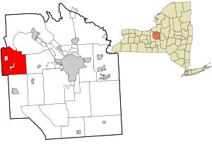
Location in Onondaga County and the state of New York.
|
|

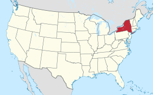
Location of New York in the United States
|
|
| Country | United States |
| State | New York |
| County | Onondaga |
| Territorial Subdivision | 1829 |
| Area | |
| • Total | 38.30 sq mi (99.18 km2) |
| • Land | 37.54 sq mi (97.22 km2) |
| • Water | 0.76 sq mi (1.96 km2) |
| Population
(2020)
|
|
| • Total | 5,476 |
| • Density | 142.98/sq mi (55.213/km2) |
| Time zone | UTC-5 (EST) |
| • Summer (DST) | UTC-4 (EDT) |
| Area code(s) | 315 |
| FIPS code | 36-067-23800 |
| Website | TownOfElbridge.com |
Elbridge is a town in Onondaga County, New York, United States. In 2020, about 5,476 people lived there. The town is named after Elbridge Gerry, who was the fifth Vice President of the United States. He also signed the Declaration of Independence.
The Town of Elbridge is located west of Syracuse. It is on the western edge of Onondaga County. The town has two villages: Jordan and Elbridge.
Contents
History of Elbridge
Early Days and Formation
Elbridge was once part of a larger area called Military Township No. 5 (Camillus). This area was created after the American Revolution. Land here was given to soldiers instead of money for their service. The Town of Elbridge was officially formed in 1829. It was separated from the Town of Camillus.
The Town of Elbridge includes two villages. The Village of Elbridge became a village in 1848. The Village of Jordan became a village earlier, in 1835.
Native Americans and First Settlers
Before European settlers arrived, the area was home to Native American groups. The Onondaga people, part of the Iroquois Nation, had several strong settlements here. One of the largest was on the Seneca River, now called Jack's Reef. Some legends say that Cross Lake, which borders the town, was even home to the famous Hiawatha.
In 1791, a government surveyor named Josiah Buck came to map the land. Two years later, he returned with his family. They were the first European settlers in the area. Soon after, Captain William Stevens and his family arrived. Many historians believe Captain Stevens named the town after Elbridge Gerry. Gerry was a Massachusetts Governor who took part in the Boston Tea Party in 1773 with Stevens.
Village of Elbridge
Growth and Industry
The Village of Elbridge was built along an old Native American trail. This trail later became New York State Route 5. The village had many waterways, like Skaneateles Creek. These creeks provided water power for businesses. As more settlers came, the village grew. Mills, taverns, and shops opened.
Many factories used the power from Skaneateles Creek. These included chair factories and the Amphion Piano Player Company. The Elbridge Electrical Manufacturing Company made electric motors. They even produced the first electric starter for cars! The village was a busy farming and industrial place. Its busiest time was between 1850 and 1870.
Education and Historic Homes
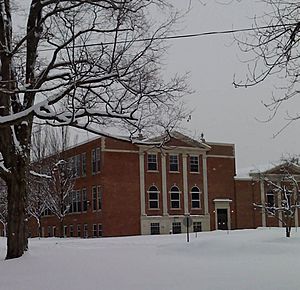
In 1835, Nathan Munro started the Munro Academy. This school later became Munro Collegiate Institute in 1854. Today, Elbridge Elementary School is on the same spot.
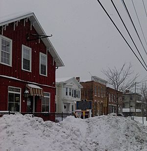
Main Street in Elbridge (Route 5) has many beautiful old homes from the 1800s. One house is even said to have been a stop on the Underground Railroad. This was a secret network that helped enslaved people find freedom. There's also the Wayside Inn, which some say is haunted! People tell stories about a friendly ghost named "George" who plays jokes.
Village of Jordan
Canal and Railroad Hub
The Village of Jordan is the larger of the two villages in Elbridge. It is located in the northwest part of the town. Jordan became a major center for trade and manufacturing. This happened because the Erie Canal was built right through the town. You can still see parts of the old Jordan aqueduct, which is now a park.
Later, the main railroad line across New York State also ran through Jordan. However, the village's success slowed down. The canal closed in 1912. Then, railroads lost business to trucks. Even though the New York State Thruway goes near Jordan, there isn't an exit for the town. Still, some businesses remain, like OWI Wire Mill and Bennet Bolt Works.
Tessy Plastics
A Local Success Story
The Town of Elbridge is home to the main office of Tessy Plastics. This company makes plastic products using a special process called injection molding. Henry Beck started the company in 1973. Today, Tessy Plastics employs about 1,000 people worldwide. About 500 of them work at the Elbridge factory.
Tessy Plastics makes parts and supplies for many big companies. These include Xerox, Gillette, Duracell, and Johnson and Johnson. Even when they lost some business, Tessy Plastics kept growing. They expanded their Elbridge factory in 2003 and 2004. This shows how important they are to the local economy.
Notable People
- John Adams (1772–1863): He was a principal at a school here. (This is not the famous President John Adams).
- Glidden Doman (1921-2016): He founded Doman Helicopters.
Geography of Elbridge
Land and Water
The Town of Elbridge covers about 38.3 square miles (99.2 km²). Most of this area is land. About 0.7 square miles (1.8 km²) is water.
The western border of the town is also the border of Cayuga County. The Erie Canal and Seneca River system forms part of the town's northern border.
Roads and Landmarks
The New York State Thruway (Interstate 90) crosses the northern part of the town. Several state roads also run through Elbridge. These include New York State Route 5 and New York State Route 31.
Communities and Locations
The Town of Elbridge has several smaller communities and interesting spots:
- Carpenter Brook Fish Hatchery: A place where fish are raised, located near the southern town line.
- Cross Lake: A lake that is partly in the northeast corner of the town.
- Elbridge: This is the Village of Elbridge, located near the center of the town.
- Jordan: This is the Village of Jordan, found in the northwest part of the town.
- Memphis: A small community on the town line in the northeast corner.
- Peru: A small community in the northern part of the town, close to I-90.
- Skaneateles Junction: A community in the southern part of the town, also known as "Hartlot."
- South Bay: A bay of Cross Lake located within the town's northern border.
Demographics
| Historical population | |||
|---|---|---|---|
| Census | Pop. | %± | |
| 1830 | 3,357 | — | |
| 1840 | 4,617 | 37.5% | |
| 1850 | 3,924 | −15.0% | |
| 1860 | 4,509 | 14.9% | |
| 1870 | 3,796 | −15.8% | |
| 1880 | 4,087 | 7.7% | |
| 1890 | 3,560 | −12.9% | |
| 1900 | 3,327 | −6.5% | |
| 1910 | 2,980 | −10.4% | |
| 1920 | 2,736 | −8.2% | |
| 1930 | 2,814 | 2.9% | |
| 1940 | 2,975 | 5.7% | |
| 1950 | 3,338 | 12.2% | |
| 1960 | 4,644 | 39.1% | |
| 1970 | 5,503 | 18.5% | |
| 1980 | 5,885 | 6.9% | |
| 1990 | 6,192 | 5.2% | |
| 2000 | 6,091 | −1.6% | |
| 2010 | 5,922 | −2.8% | |
| 2020 | 5,476 | −7.5% | |
| U.S. Decennial Census | |||
In 2000, there were 6,091 people living in Elbridge. There were 2,322 households and 1,688 families. The population density was about 162 people per square mile. Most people (97.70%) were White. About 1.10% of the population was Hispanic or Latino.
About 36.5% of households had children under 18 living with them. About 56.9% were married couples. The average household had 2.62 people. The average family had 3.08 people.
The median age in the town was 38 years old. About 27.3% of the population was under 18. About 13.1% were 65 or older. The median income for a household was $41,444. For a family, it was $48,085. About 6.9% of the population lived below the poverty line.
See also
 In Spanish: Elbridge (Nueva York) para niños
 | Aaron Henry |
 | T. R. M. Howard |
 | Jesse Jackson |


