
St. George, Staten Island facts for kids
Quick facts for kids
St. George
|
|
|---|---|
|
Neighborhood of Staten Island
|
|

Skyline of St. George
|
|
| Country | |
| State | |
| City | |
| Borough | |
| Community District | Staten Island 1 |
| Area | |
| • Total | 1.07 km2 (0.412 sq mi) |
| Population
(2011)
|
|
| • Total | 8,662 |
| • Density | 8,118/km2 (21,024/sq mi) |
| Economics | |
| • Median income | $46,646 |
| Time zone | UTC−5 (Eastern) |
| • Summer (DST) | UTC−4 (EDT) |
| ZIP Codes |
10301
|
| Area code | 718, 347, 929, and 917 |
St. George is a neighborhood located on the northeastern tip of Staten Island in New York City. It sits right along the waterfront where the Kill Van Kull meets Upper New York Bay. This area is the most developed part of Staten Island. It's also where the main government offices for the borough and Richmond County are located.
The St. George Terminal is a very important spot here. It serves the Staten Island Ferry and the Staten Island Railway. St. George is next to Tompkinsville to the south and New Brighton to the west.
Long ago, the Lenape Native Americans lived here. Later, Dutch and British settlers arrived. The first homes were built in the 1830s. By the late 1800s, it was a popular summer resort. The area became known as St. George after developer George Law. This happened when Erastus Wiman promised to "canonize" Law for giving up land for the ferry-railroad terminal. Many important buildings were built in St. George in the early 1900s. New waterfront projects began in the early 2000s.
St. George is part of Staten Island Community District 1. The New York City Police Department's 120th Precinct patrols the neighborhood.
Contents
Exploring St. George's Past
Early Days: Native Americans and Colonists
Staten Island was first home to the Munsee-speaking Lenape Native Americans. They moved with the seasons. In summer, they fished by the shore. In fall and winter, they hunted and grew crops inland.
In 1624, Dutch settlers came to the New York City area. They called it New Netherland. In 1664, the Dutch gave New Netherland to the British. Six years later, the British bought land from the Lenape.
By 1748, a ferry to Manhattan was running from this area. A molasses factory also opened near the waterfront. Two Native American roads met near the factory. One was Shore Road (now Richmond Terrace). The other went south on St. Marks Place.
During the American Revolutionary War, the British built a fort on Fort Hill. Hessian soldiers, who fought for the British, were stationed near a brook. This brook became known as Hessian Springs. After the war, the area stayed mostly rural. In 1799, the state built a hospital for contagious diseases here. The federal government also built a lighthouse facility.
The 1800s: Growth and Change
How St. George Began to Grow
Daniel D. Tompkins, a former U.S. vice president, helped develop Staten Island. He bought land in the northern part of the island in the early 1810s. Tompkins also started a ferry to Manhattan in 1817. He planned the nearby village of Tompkinsville.
In 1834, Tompkins's land was sold to Thomas E. Davis, a developer from Manhattan. Davis bought all the land on Staten Island's northeastern shore. He planned to create a summer retreat called New Brighton. The first summer homes were built in 1835. Davis sold the development in 1836. The area, including what is now St. George, was then called New Brighton.
Developing the Neighborhood
Streets in New Brighton were planned around the existing land. Many roads were named after famous politicians. Others were named after people or places linked to the area's development. For example, St. Marks Place was named after Davis's projects in Manhattan.
Building continued, but a financial crisis in 1837 slowed things down. The Pavilion Hotel opened in 1837. In 1840, some investors lost their properties. Thomas E. Davis bought them back in 1844. By then, several streets were laid out in modern-day St. George. Most development was along the waterfront.

St. Peter's Church opened in 1844. It was the island's first Roman Catholic church. By the 1840s and 1850s, New Brighton became a summer resort. New hotels and homes were built. Factories also opened, causing the population to double between 1840 and 1860.
In 1858, residents burned down the Quarantine hospital. This was known as the Staten Island Quarantine War. The American Civil War (1861-1865) brought many new people to New York City. This led to more demand for homes on Staten Island. Many new houses were built during this time. After the war, real estate prices went up.
A financial crisis in 1873 stopped building for a while. But by the late 1870s, industries returned. A water system was built in 1879, and a sewage system followed.
St. George Gets Its Name
In the 1880s, the area near the ferry terminals became known as "St. George." It was named after developer George Law. A businessman named Erastus Wiman was extending the Staten Island Railway. He promised to honor Law if Law gave up land for a new terminal.
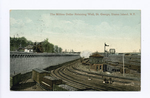
St. George was chosen for the terminal because it was the closest point from Staten Island to Manhattan. The St. George Terminal opened in 1886. It offered ferry service to Manhattan and three train lines.
New transportation led to more building. Developers built cottages and houses. Many new homes were in popular styles like Queen Anne and Colonial Revival. In 1898, Staten Island joined New York City. This sped up development. Immigrant groups also settled in the area. George Cromwell, Staten Island's first borough president, moved the county capital to St. George. He said it was easier to reach from Manhattan.
St. George in the 20th Century
After New York City Unification


After Staten Island joined New York City, the North Shore became very urban. St. George became the political and economic center. By the 1900s, St. George was mostly residential and commercial. Many government buildings were built here.
Curtis High School, the first high school on Staten Island, opened in 1904. The ferry service became a city operation in 1905. St. George grew more urban because of easy ferry access. Electric streetlights were installed by 1912. New commercial and government buildings went up. Other city services like schools and utilities also came to Staten Island.
The architects Carrère and Hastings designed several buildings in St. George. These include the St. George Library Center (1907), the Staten Island Borough Hall (1906), and the Richmond County Courthouse (1919). The Staten Island Museum moved to St. George in 1918. Other important buildings from the 1920s and 1930s include the St. George Theatre (1927) and the Staten Island Savings Bank (1936).
A plan for a train tunnel to Brooklyn was proposed in 1912. It was hoped to make travel to Manhattan much faster. However, the project was canceled in 1925. Another plan for a large ferry terminal with offices was proposed in 1930 but never built.
Mid to Late 1900s
By the 1930s, "St. George" generally described the entire northeastern corner of Staten Island. Many older homes were turned into small apartment buildings. The U.S. Light-House Depot Complex became part of the United States Coast Guard in 1936.
After a fire in 1946, the St. George Terminal was rebuilt. It reopened in 1951 with new features. The opening of the Verrazzano-Narrows Bridge in 1964 connected Staten Island to the rest of New York City. This meant people didn't have to pass through St. George as much. The Coast Guard complex closed in 1965.
By the 1970s, demand for homes in St. George went down. A large apartment building was built near the ferry terminal. A big residential complex was planned but not built until 1981. This smaller project was called Bay Street Landing.
St. George's Comeback
The community started to improve in the late 1980s. Developers proposed a large retail and commercial complex. Redevelopment continued through the 1990s. In 1994, the New York City Landmarks Preservation Commission created the St. George Historic District. This district includes 78 houses and St. Peter's Church.

In the early 2000s, several important structures in St. George were updated or opened. The Richmond County Bank Ballpark (now SIUH Community Park) opened in 2001. The St. George Theater reopened in 2004. The Postcards 9/11 memorial also opened in 2004. The ferry terminal was renovated in 2005.
By the mid-2000s, new buildings were appearing near the ferry terminal. Artists and musicians began moving to Staten Island's North Shore. They could find more affordable living and working space there. In 2008, a special zoning district was created for St. George. Pier 1 was renovated in 2009 to create a public fishing pier.
Development on the shore and Bay Street continued in the 2010s. The National Lighthouse Museum opened in 2015. The Empire Outlets mall opened in May 2019. A large Ferris wheel project, the New York Wheel, was canceled in 2018. Lighthouse Point, south of the terminal, was also delayed.
People of St. George
St. George is part of a larger area called West New Brighton-New Brighton-St. George. In 2010, this area had 33,551 people. The population included a mix of White, African American, Asian, and Hispanic or Latino residents.
Most people in Community District 1, which includes St. George, are young and middle-aged adults. About 24% are under 18, and 27% are between 25 and 44. The average life expectancy is 79.0 years.
In 2017, the average household income in St. George was $46,646. About 21% of residents in St. George and the North Shore live in poverty. This is similar to the rest of New York City.
Buildings and Landmarks
Places of Worship
The Brighton Heights Reformed Church is a historic site. It was rebuilt in 1999 after a fire in 1996. St. Peter's Church, built in 1844, was the first Roman Catholic church on the island. It is still a very important church today.
Homes and Apartments
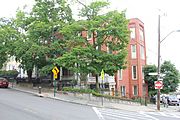
The Fort Hill area has old streets and homes where important families lived. These include the homes of Daniel D. Tompkins and Daniel Low. Many houses here show different styles of Victorian, Tudor, and Art Deco designs. Some homes are even modeled after a Spanish castle.
There are also several apartment buildings in St. George. The Ambassador Apartments, built in 1932, are in the Art Deco style. The 20-story Castleton Park Apartments are thought to be the tallest buildings on Staten Island.
Several houses are official city landmarks. Part of the neighborhood is in the St. George/New Brighton Historic District. This district has 78 houses and St. Peter's Church. The houses are in various Victorian styles.
- Houses in St. George
-
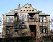
Victorian home in the St. George Historic District
-
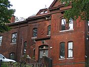
Mansion on Daniel Low Terrace
-
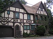
Tudor-style home on Fort Hill where a British fort once stood
-
Horton's Row house


Fun Things to Do in St. George
The municipal parking lot on Hyatt Street hosts a greenmarket in spring, summer, and fall. This lot is built over an old graveyard from the former quarantine hospital.
Entertainment and Shopping
.jpg)
The St. George Theatre is a large theater with 2,800 seats. It hosts concerts, comedy shows, and educational programs. The theater opened in 1929 and was renovated in 2004. Its inside has beautiful Spanish and Italian Baroque designs.
The SIUH Community Park (formerly Richmond County Bank Ballpark) is on the waterfront. It was home to the Staten Island Yankees baseball team. Now, it's home to the Staten Island FerryHawks. This 7,171-seat stadium opened in 2001.
Empire Outlets, a shopping mall, opened in St. George in May 2019. It is located next to where the New York Wheel was planned. The New York Wheel was a giant Ferris wheel project that was canceled in 2018.
Museums and Memorials
The Staten Island Museum is located near the St. George Terminal. It explores the arts, natural science, and local history of the island. The museum building was built in 1927.
The National Lighthouse Museum opened in 2015. It is dedicated to the history of lighthouses in the United States.
The Postcards memorial is on the St. George waterfront. This September 11 memorial opened in 2004. It has two tall white marble sculptures. They look like large postcards to remember loved ones.
Important Services
Fire Safety
The New York City Fire Department (FDNY) has Engine Co. 155/Ladder Co. 78 in St. George. It is located at 14 Brighton Avenue.
Post Office and ZIP Code
St. George uses the ZIP Code 10301. The United States Postal Service operates the Saint George Station at 45 Bay Street.
Education
St. George and the North Shore have a lower rate of college-educated residents compared to the rest of New York City. About 37% of adults have a college education or higher.
The percentage of elementary school students who miss many school days is slightly higher here. About 25% of students miss twenty or more days per school year. However, 73% of high school students graduate on time. This is similar to the city average.
Schools in St. George
The New York City Department of Education runs five public schools in St. George:
- PS 16 John J Driscoll (grades PK-5)
- PS 31 William T Davis (grades PK-5)
- PS 74 Future Leaders Elementary School (grades K-5)
- Curtis High School (grades 9–12); this was the first high school on Staten Island
- Ralph R McKee Career and Technical Education High School (grades 9–12)
St. George Library Center

The New York Public Library's St. George Library Center is the main library for Staten Island. It is located across from Borough Hall. The library was built in 1906–1907. It has three stories, including a children's collection and a young adult section.
Getting Around St. George


St. George Terminal is a major transportation hub. It connects ferries, trains, and buses. It also has a parking lot. The terminal opened in 1886 and was last renovated in 2005. It offers great views of the harbor.
Almost all Staten Island bus routes serve St. George Terminal. The Staten Island Railway and the Staten Island Ferry also operate from here. Additionally, the NYC Ferry has a St. George route.
Famous People from St. George
- Paul Newman and his wife Joanne Woodward, both actors, lived in the Ambassador apartment building.
- Actor Martin Sheen lived in the Ambassador building. His son, Emilio Estevez, was born there.
- Max Rose, a former congressman, lives in St. George.
Images for kids
