
New Brighton, Staten Island facts for kids
Quick facts for kids
New Brighton
|
|
|---|---|
|
Neighborhood of Staten Island
|
|

View of Brighton, Staten Island, New York, an 1857 engraving
|
|
| Country | |
| State | |
| City | |
| Borough | |
| Community District | Staten Island 1 |
| Area | |
| • Total | 0.93 km2 (0.361 sq mi) |
| Population
(2011)
|
|
| • Total | 5,795 |
| • Density | 6,198/km2 (16,053/sq mi) |
| Economics | |
| • Median income | $49,807 |
| ZIP Codes |
10301
|
| Area code | 718, 347, 929, and 917 |
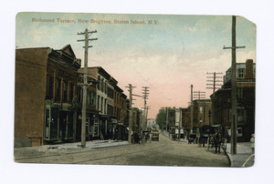
New Brighton is a neighborhood on the North Shore of Staten Island in New York City. It's an old area with both factories and homes along the harbor. This area is next to the Kill Van Kull waterway, west of St. George.
New Brighton is bordered by the Kill Van Kull to the north. To the east is Jersey Street. Brighton and Castleton Avenues are to the south. Lafayette Avenue and the Snug Harbor Cultural Center are to the west. It is close to St. George, Tompkinsville, and West New Brighton.
New Brighton became its own village in 1866. It was formed from parts of the town of Castleton. The village was once much larger, covering the entire northeast tip of Staten Island. This included the area now known as St. George. Today, New Brighton has a special area called Hamilton Park. This park has many Victorian homes built before the American Civil War. You can also find old churches here, like St. Peter's Church. This is the oldest Roman Catholic church on Staten Island.
New Brighton is part of Staten Island Community District 1. Its main ZIP Codes are 10304 and 10301. The New York City Police Department's 120th Precinct patrols the neighborhood.
Contents
Exploring New Brighton's Past
Early Days and Native Americans
Long ago, Staten Island was home to the Lenape Native Americans. They spoke the Munsee language. The Lenape moved around with the seasons. They fished by the shore in summer. In fall and winter, they hunted and grew crops inland.
In 1624, Dutch settlers arrived in the area. They made it part of New Netherland. In 1664, the Dutch gave New Netherland to the British. Six years later, the British bought the land from the Lenape.
How Land Was Divided
When the British took over, many settlers lived in the area. But they didn't officially own the land. So, surveys were done until 1677. Land was then given to different owners. One large piece of land was called "Duxbury Glebe." It was 340 acres. Another piece of land was given to Lambert Jansen Dorlant in 1680. A small brook on today's Jersey Street was its western edge.
By 1748, Salmon Comes owned this land. He ran a ferry to Manhattan. Later, John Wandel owned part of it. He had a molasses factory near the Kill Van Kull. He used the Jersey Street brook for his factory. Two Native American roads met near his factory. One was Shore Road (now Richmond Terrace). The other went south on St. Marks Place.
Fort Hill and the American Revolution
Fort Hill was a high point overlooking the harbor. The British built defenses there during the American Revolutionary War. Hessian soldiers, who fought for the British, stayed near the Jersey Street brook. This brook became known as Hessian Springs. After the war, the area stayed mostly rural. It became part of the town of Castleton in 1788.
New Brighton's Growth in the 1800s
Daniel D. Tompkins' Vision
Daniel D. Tompkins was a former U.S. vice president. He helped develop Staten Island. In the early 1810s, he bought land in northern Staten Island. He bought a farm on Jersey Street in 1814. He also bought 700 acres from St. Andrew's Church.
Tompkins started the Richmond Turnpike Company in 1816. They built today's Victory Boulevard. He also started a ferry service to Manhattan in 1817. He planned the nearby village of Tompkinsville. Tompkins lived in an old farmhouse that he expanded. He passed away in 1825.
The Birth of New Brighton
In 1834, Tompkins' land was sold to Thomas E. Davis. Davis was a developer from Manhattan. He bought more land and soon owned all the land on Staten Island's northeast shore. This land stretched from Victory Boulevard to Sailors' Snug Harbor.
Davis wanted to create a summer getaway called New Brighton. He changed Shore Road to Richmond Terrace. In 1835, the first five Greek Revival summer homes were built. In 1836, Davis sold the development to a group of five people. They formed the New Brighton Association. This is how the area got its name.
Building the Neighborhood
A surveyor named James Lyons created a plan for New Brighton's streets in 1835. Streets were built to fit the land. Many roads were named after famous politicians. Examples include Hamilton Avenue and Madison Street. Other streets were named after people or places important to the area's development. St. Marks Place was named after Davis's projects in Manhattan. Westervelt Avenue was named after Tompkins' son-in-law.
Building continued, but a major investor went bankrupt in 1837. The Pavilion Hotel opened that same year. In 1840, four of the five original investors lost their properties. Thomas E. Davis bought them back in 1844. By 1845, many streets were laid out. Most of the development was along the waterfront. There were large homes, smaller houses, and the Pavilion Hotel.
St. Peter's Church opened in 1844. It was the first Roman Catholic church on the island. It is still very important today. Many other Catholic churches on Staten Island came from St. Peter's parish. Two old Greek Revival houses still stand on Richmond Terrace.
A Growing Resort Area
By the 1840s and 1850s, New Brighton became a popular summer resort. More hotels opened, like the Peteler Hotel and the Belmont Hotel. New homes, like Italianate villas, were built. Existing mansions on Richmond Terrace were made bigger. Greenhouses were also built, especially on John C. Green's land. This land is now Curtis High School.
A silk printing factory, Crabtree and Wilkinson, opened in 1844. It had over 180 workers. Other factories opened too. This caused New Brighton's population to double between 1840 and 1860.
Changes During the Civil War
The American Civil War started in 1861. At first, New Brighton's economy struggled. But the Union Army needed supplies. Many workers moved to New York City, including Staten Island. This led to a high demand for homes. Many new houses were built in the Second Empire style. After the war, building materials became cheaper. Technology improved. This led to higher real estate prices. By the early 1870s, the area was thriving.
Late 1800s Development
The New Brighton Village Hall was built in 1871. It was one of the few village halls left when Staten Island joined New York City. An old description from 1886 called New Brighton "unique in its attractiveness." It had nice buildings, churches, and homes. Its streets were wide and tree-lined. The people took great care of their homes and lawns.
A financial crisis in 1873 slowed building. But by the late 1870s, industries returned. A water system was built in 1879. A sewage system was added between 1884 and 1890. In the 1880s, the area near the ferry terminals became "St. George." This was named after developer George Law. The St. George Terminal opened in 1886. This brought more growth to the neighborhood.
New transportation options led to more homes being built. Developers built cottages and houses. Many newer homes were in the Queen Anne, Shingle, and Colonial Revival styles. In 1898, Staten Island joined New York City. This sped up development. More immigrant groups moved to New Brighton. Italians and African-Americans settled near the Kill Van Kull. Jewish communities settled near St. George and Tompkinsville.
The 1900s and Beyond

After joining New York City, the North Shore became very urban. It became the center of Staten Island. The first high school, Curtis High School, opened in 1904. Ferry service to Manhattan became a city service in 1905. Other city services came to Staten Island too. These included schools, emergency services, new roads, and water pipes.
Nearby St. George became Staten Island's civic center. The new Staten Island Borough Hall was built in 1906. The Richmond County Courthouse followed in 1919. This led to better roads, police, and fire protection.
Staten Island and New Brighton grew economically. Large factories like Procter & Gamble and US Gypsum provided many jobs. The Procter & Gamble factory opened in 1907 and ran for over 80 years. In the late 1920s, some of the first apartment buildings were built in New Brighton.
The Verrazzano-Narrows Bridge opened in 1964. This bridge connected Brooklyn and Staten Island. It led to a huge increase in population and development. Many factories in the area closed. New housing projects were built. These changes, along with increased poverty, greatly changed New Brighton.
Who Lives in New Brighton?
New Brighton is part of a larger area called West New Brighton-New Brighton-St. George. In 2010, this area had 33,551 people. This was a small increase from 2000.
The people living here are from many different backgrounds. In 2010, about 26% were White, 31% were African American, and 5% were Asian. About 33% of the people were Hispanic or Latino.
The average life expectancy in this area is 79 years. This is a bit lower than the average for all New York City neighborhoods. Many residents are young or middle-aged adults. About 24% are under 18. About 27% are between 25 and 44.
In 2017, the average household income in New Brighton was $49,807. About 21% of residents live in poverty. This is similar to the rest of Staten Island and New York City. About 7% of residents are unemployed. Many residents (51%) have trouble paying their rent.
Fun Places to Visit in New Brighton
New Brighton has several important historical places. These include One Pendleton Place, Christ Church New Brighton (Episcopal), Hamilton Park Community Houses, and Neville House. They are all listed on the National Register of Historic Places.
Snug Harbor Cultural Center and Botanical Gardens

Sailors' Snug Harbor was built in 1833. It was created by a rich New Yorker named Robert Richard Randall. It was the first place in the United States for retired sailors. This 83-acre park is on the North Shore of Staten Island. It's along the Kill Van Kull.
Snug Harbor has 26 buildings in different styles. These include Greek Revival, Beaux Arts, Italianate, and Victorian styles. At its busiest, 1,000 sailors lived there. But it closed in the 1960s due to less funding.
Today, Snug Harbor is called the Snug Harbor Cultural Center and Botanical Gardens. It's seen as Staten Island's "crown jewel." It has gardens, museums, theaters, and educational spaces. It also hosts special events. It is a National Historic Landmark District.
St. Peter's Church
The first Mass for St. Peter's Roman Catholic Church was held in 1839. It was in a gun factory in New Brighton. The New Brighton Association later gave land for the church. It opened in 1844 near its current spot on St. Mark's Place.
A fire destroyed the first church in the 1890s. A new church building was finished in 1903. It has a French-Gothic style inside. You can see its curved, pointed ceilings. The church can be seen from almost anywhere in New Brighton. It stands out when you arrive by the Staten Island Ferry.
W.S. Pendleton Houses


The W.S. Pendleton Houses are at 1 and 22 Pendleton Place. They are special landmarks of New York City. 1 Pendleton Place was also added to the National Register of Historic Places in 2014. Both houses belonged to W.S. Pendleton. He was a local businessman who worked in real estate. He also owned a ferry boat company.
1 Pendleton Place was built in 1861. It was designed in the Stick style. 22 Pendleton Place was built in 1855. It's a Gothic Revival style house. It has a unique look with its square, spire-topped tower. It also has steep roofs and bay windows.
Atlantic Salt Company
The Atlantic Salt Company is on Richmond Terrace. It stores salt used to melt ice on roads. This salt is used in New York, New Jersey, and Connecticut. You can see large hills of white salt from the road. In winter, over 350,000 tons of salt are stored here. The company bought this location in 1976. It is a family-run business.
September 11 Memorial
A large mural is painted on the side of a warehouse on Richmond Terrace. This warehouse is where Gerardi's Farmer Market is. A local artist, known as FWID, painted it. The mural shows three firefighters raising the American Flag. This image reminds people of the famous photo, "Raising the Flag on Iwo Jima."
Gerardi's Farmer Market

Gerardi's Farmer Market is a local market on Richmond Terrace. It sells fresh, local produce almost all year round. It serves the people of New Brighton.
Hamilton Park: A Historic Community
Hamilton Park, also called Cottage Hill, was planned around 1851-52. It was likely the first suburban residential park on Staten Island. It was one of the first private suburban areas in the United States. It was not connected to the main street grid until 1886. It's a large, high area. You can still see parts of the old roads that wound through the woods.
Hamilton Park is a close-knit community. It sits on top of a hill called "Brighton Heights." This hill is one of the highest points on the eastern seaboard below Maine. The hilly streets of Hamilton Park have many gingerbread-trimmed Victorian mansions. They also have shingle-style homes built during the Civil War.
Many large country homes, called "cottages," still exist. 66 Harvard Avenue, the C.K. Hamilton House, was built around 1853. It was part of Hamilton Park Community Houses. It is thought to be the first "cottage" built for sale. It is the only original suburban home still standing. The German architect Carl Pfeiffer designed 12 houses for Hamilton in the early 1860s. Many of these still exist today.
Safety and Services
Fire Safety
The New York City Fire Department (FDNY) helps keep New Brighton safe. Engine Co. 155/Ladder Co. 78 is located at 14 Brighton Avenue.
Post Offices and ZIP Codes
New Brighton uses the ZIP Code 10301. The United States Postal Service has two offices nearby. The Saint George Station is at 45 Bay Street. The West New Brighton Station is at 1015 Castleton Avenue.
Learning in New Brighton
New Brighton and the North Shore have fewer college-educated residents than the rest of New York City. About 37% of adults aged 25 and older have a college degree. However, 15% have less than a high school education.
More elementary school students in New Brighton miss school. About 25% miss 20 or more days a year. This is higher than the city average. For high school students, about 73% graduate on time. This is similar to the city average.
Schools in the Neighborhood
The New York City Department of Education runs public schools near New Brighton:
- PS 31 William T Davis (for grades PK-5)
- IS 61 William A Morris (for grades 6–8)
- PS 373 (for grades PK-7)
The Roman Catholic Archdiocese of New York operates Catholic schools. St. Peter-St. Paul Parish School is in New Brighton. In 2011, St. Peter's moved to the old Saint Paul Elementary School building. The school changed its name after the move.
Libraries for Learning
The closest library is the New York Public Library (NYPL)'s West New Brighton branch. It is at 976 Castleton Avenue in West New Brighton. The NYPL also has the St. George Library Center. This library is at 5 Central Avenue in St. George.
Getting Around New Brighton
New Brighton used to have a train station on the Staten Island Railway. This was the New Brighton station. But the train line closed on March 31, 1953.
Today, New Brighton is served by several local bus routes. These include the S40, S42, S44, S46, S52, S90, S94, S96 buses.
Notable People from New Brighton
- Walter Davis Lambert (1879–1968), a geodesist (someone who studies Earth's shape), was born here.
- Mabel Normand (1892–1930), a famous silent film actress, was born in New Brighton.
- William Greenough Thayer (1863–1934), an educator, was also born here.
The movie Vox Lux also has parts that relate to New Brighton.
Images for kids
-
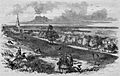
View of Brighton, Staten Island, New York, an 1857 engraving
