St. Lawrence County, New York facts for kids
Quick facts for kids
St. Lawrence County
|
|||
|---|---|---|---|

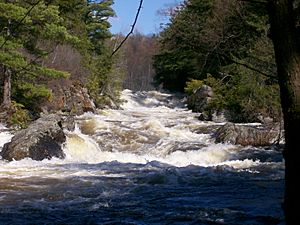
The Raquette River in Colton, New York
|
|||
|
|||

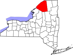
Location within the U.S. state of New York
|
|||
 New York's location within the U.S. |
|||
| Country | |||
| State | |||
| Founded | 1802 | ||
| Named for | Saint Lawrence River | ||
| Seat | Canton | ||
| Area | |||
| • Total | 2,821 sq mi (7,310 km2) | ||
| • Land | 2,680 sq mi (6,900 km2) | ||
| • Water | 141 sq mi (370 km2) 5.0% | ||
| Population
(2020)
|
|||
| • Total | 108,505 |
||
| • Density | 38/sq mi (15/km2) | ||
| Time zone | UTC−5 (Eastern) | ||
| • Summer (DST) | UTC−4 (EDT) | ||
| Congressional district | 21st | ||
St. Lawrence County is a large county located in the northern part of New York State. In 2020, about 108,505 people lived there. The main town, or county seat, is Canton.
The county gets its name from the Saint Lawrence River. An early French explorer, Jacques Cartier, named the river after Lawrence of Rome, a Christian saint. He visited the river on the saint's special day. St. Lawrence County is part of the "North Country" region of New York. It is also the largest county in New York by total area.
Contents
History of St. Lawrence County
When counties were first created in New York in 1683, the area that is now St. Lawrence County was part of a huge area called Albany County. This original Albany County was enormous. It covered the northern part of New York and even included land that is now the state of Vermont. It was even thought to stretch all the way to the Pacific Ocean!
Over time, Albany County became smaller. In 1766, Cumberland County was formed. Then, in 1770, Gloucester County was created. Both of these new counties took land from Albany County that is now in Vermont.
In 1772, the remaining Albany County was divided into three parts. One part stayed as Albany County. The other two were named Tryon County and Charlotte County.
Tryon County covered the western part of New York. It included parts of the Adirondack Mountains. Charlotte County was the eastern part of the original Albany County.
After the American Revolutionary War ended in 1784, county names changed. Charlotte County was renamed Washington County to honor George Washington. Tryon County became Montgomery County. This honored General Richard Montgomery, who was a hero in the war.
More changes happened in the following years. In 1788, Clinton County was formed from Washington County. This new Clinton County was much larger than it is today. It included some land that would later become part of St. Lawrence County.
In 1791, Herkimer County was created from Montgomery County. This county was also very large at first. It was later divided many times.
Finally, in 1802, parts of Clinton, Herkimer, and Montgomery counties were combined. This created the new St. Lawrence County. At first, Ogdensburg was the county seat. But in 1828, the county seat was moved to Canton. This move was a compromise to settle a disagreement between Ogdensburg and Potsdam over which town should be the county seat.
The 1944 Earthquake
On September 5, 1944, a strong earthquake hit St. Lawrence County. It had a magnitude of 5.8. The earthquake was centered near Massena. People felt it from Canada all the way to Maryland, and from Maine to Indiana. This earthquake was the strongest one ever recorded in New York State.
Geography of St. Lawrence County
St. Lawrence County covers about 2,821 square miles (7,306 km²). About 2,680 square miles (6,941 km²) is land, and 141 square miles (365 km²) is water.
It is the largest county in New York State by land area. It is even bigger than the states of Rhode Island or Delaware! St. Lawrence County is part of the "North Country" region.
A large part of the county is inside the Adirondack Park. This park is a protected area with beautiful nature. The county also includes much of the Oswegatchie River, Cranberry Lake, and Lake Ozonia.
The Port of Ogdensburg is in St. Lawrence County. It is the only U.S. port on the St. Lawrence Seaway. This important waterway lets ships travel through the St. Lawrence River to the Great Lakes. The Ogdensburg Harbor Light is a historic lighthouse here.
Neighboring Counties
St. Lawrence County shares borders with several other counties and even Canada:
- Stormont, Dundas and Glengarry United Counties, Ontario, Canada – to the north
- Leeds and Grenville United Counties, Ontario, Canada – to the northwest
- Franklin County – to the east
- Herkimer County – to the south
- Hamilton County – to the south
- Lewis County – to the southwest
- Jefferson County – to the west
Population and People
| Historical population | |||
|---|---|---|---|
| Census | Pop. | %± | |
| 1810 | 7,885 | — | |
| 1820 | 16,037 | 103.4% | |
| 1830 | 36,354 | 126.7% | |
| 1840 | 56,706 | 56.0% | |
| 1850 | 68,617 | 21.0% | |
| 1860 | 83,689 | 22.0% | |
| 1870 | 84,826 | 1.4% | |
| 1880 | 85,997 | 1.4% | |
| 1890 | 85,048 | −1.1% | |
| 1900 | 89,083 | 4.7% | |
| 1910 | 89,005 | −0.1% | |
| 1920 | 88,121 | −1.0% | |
| 1930 | 90,960 | 3.2% | |
| 1940 | 91,098 | 0.2% | |
| 1950 | 98,897 | 8.6% | |
| 1960 | 111,239 | 12.5% | |
| 1970 | 111,991 | 0.7% | |
| 1980 | 114,254 | 2.0% | |
| 1990 | 111,974 | −2.0% | |
| 2000 | 111,931 | 0.0% | |
| 2010 | 111,944 | 0.0% | |
| 2020 | 108,505 | −3.1% | |
| U.S. Decennial Census 1790–1960 1900–1990 1990–2000 2010–2020 |
|||
In 2000, there were 113,931 people living in St. Lawrence County. The population density was about 42 people per square mile. Most people (94.51%) were White. About 2.38% were African American, and 0.87% were Native American.
Many people in the county have French, Irish, American, English, French Canadian, German, or Italian roots. Most people (95.6%) spoke only English at home. About 3.2% spoke French, and 1.2% spoke Spanish.
The average age of people in the county was 35 years old. About 23.4% of the population was under 18 years old.
2020 Census Information
Here's a look at the different groups of people living in St. Lawrence County based on the 2020 Census:
| Race | Num. | Perc. |
|---|---|---|
| White (NH) | 96,556 | 90% |
| Black or African American (NH) | 2,788 | 3% |
| Native American (NH) | 1,143 | 1.1% |
| Asian (NH) | 1,089 | 1% |
| Pacific Islander (NH) | 19 | 0.01% |
| Other/Mixed (NH) | 4,078 | 4% |
| Hispanic or Latino | 2,832 | 2.61% |
Education in St. Lawrence County
School Districts
St. Lawrence County has 17 school districts within its borders. Most of these schools are overseen by the St. Lawrence-Lewis BOCES Supervisory District. This district also helps the Harrisville Central School District in Lewis County, New York.
Here are some of the school districts in the county:
- Brasher Falls Central School District: St. Lawrence Central School, Brasher Falls
- Canton Central School District: Hugh Williams Senior High School, Canton
- Clifton-Fine Central School District: Clifton-Fine Central School, Star Lake
- Colton-Pierrepont Central School District: Colton-Pierrepont Central School, Colton
- Edwards-Knox Central School District: Edwards-Knox Central School, Russell
- Gouverneur Central School District: Gouverneur Junior/Senior High School, Gouverneur
- Hammond Central School District: Hammond Central School, Hammond
- Hermon-Dekalb Central School District: Hermon-Dekalb Central School, Dekalb Junction
- Heuvelton Central School District: Heuvelton Central School, Heuvelton
- Lisbon Central School District: Lisbon Central School, Lisbon
- Madrid-Waddington Central School District: Madrid-Waddington Central School, Madrid
- Massena Central School District: Massena Senior High School, Massena
- Morristown Central School District: Morristown Central School, Morristown
- Norwood-Norfolk Central School District: Norwood-Norfolk Central School, Norfolk
- Ogdensburg City School District: Ogdensburg Free Academy, Ogdensburg
- Parishville-Hopkinton Central School District: Parishville-Hopkinton Central School, Parishville
- Potsdam Central School District: Potsdam High School, Potsdam
Other school districts that have some territory in the county include:
- Alexandria Central School District
- Brushton-Moira Central School District
- Harrisville Central School District
- Indian River Central School District
- Salmon River Central School District
- St. Regis Falls Central School District
- Tupper Lake Central School District
All public high schools in St. Lawrence County compete in sports. They are part of the New York State Public High School Athletic Association Section X Northern Athletic Conference.
Universities and Colleges
St. Lawrence County is home to several colleges and universities:
- St. Lawrence University
- State University of New York at Potsdam (SUNY Potsdam)
- Clarkson University
- SUNY-ESF Ranger School
- State University of New York at Canton (SUNY Canton)
Media
Radio Stations
You can listen to these radio stations in St. Lawrence County:
- 1340 WMSA, Massena
- WVLF-FM Mix 96.1
- WRCD-FM 101.5 The Fox
- WSNN (99.3, Potsdam)
- WPDM (1470, Potsdam)
- WSLU (89.5, Canton)
Transportation
Airports
There are several public airports in St. Lawrence County:
- Massena International Airport (MSS) – in Massena
- Ogdensburg International Airport (OGS) – in Ogdensburg
- Potsdam Municipal Airport (PTD) – in Potsdam
- Moores Airport (1E8) – in Degrasse
Communities in St. Lawrence County
Larger Towns and Villages
Here are some of the larger communities in St. Lawrence County:
| # | Location | Population | Type | Area |
|---|---|---|---|---|
| 1 | ‡Akwasasne | About 12,000 | CDP/Reservation | Riverside |
| 2 | Massena | 10,883 | Village | Riverside |
| 3 | Ogdensburg | 10,436 | City | Riverside |
| 4 | Potsdam | 9,428 | Village | East |
| 5 | †Canton | 6,314 | Village | Center |
| 6 | Gouverneur | 3,949 | Village | Riverside |
| 7 | Norwood | 1,560 | Village | Riverside |
| 8 | Norfolk | 1,327 | CDP | Riverside |
| 9 | Hannawa Falls | 1,042 | CDP | East |
| 10 | Waddington | 972 | Village | Riverside |
| 11 | Star Lake | 809 | CDP | South |
| 12 | Madrid | 757 | CDP | Riverside |
| 13 | Heuvelton | 714 | Village | Riverside |
| 14 | Brasher Falls | 669 | CDP | East |
| 15 | Parishville | 647 | CDP | East |
| 16 | Hailesboro | 624 | CDP | South |
| 17 | DeKalb Junction | 519 | CDP | East |
| 18 | Winthrop | 510 | CDP | East |
| 19 | Edwards | 439 | CDP | South |
| 20 | Hermon | 422 | CDP | Center |
| 21 | Morristown | 395 | CDP | Riverside |
| 22 | Colton | 345 | CDP | East |
| 23 | Rensselaer Falls | 332 | Village | Riverside |
| 24 | Richville | 323 | Village | South |
| 25 | Hammond | 280 | Village | Riverside |
| 26 | Cranberry Lake | 200 | CDP | Southeast |
† - County Seat
‡ - Not Wholly in this County
Towns
Hamlets
- Balmat
- Conifer
- Crary Mills
- Helena
- Massena Center
- Morley
- Newton Falls
- Pyrites
- Rooseveltown
- South Colton
- Wanakena
- Chase Mills
See also
 In Spanish: Condado de St. Lawrence (Nueva York) para niños
 | Janet Taylor Pickett |
 | Synthia Saint James |
 | Howardena Pindell |
 | Faith Ringgold |


