De Kalb, New York facts for kids
Quick facts for kids
DeKalb, New York
|
|
|---|---|

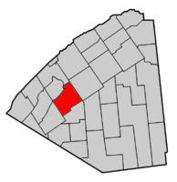
Map highlighting De Kalb's location within St. Lawrence County.
|
|
| Country | United States |
| State | New York |
| County | St. Lawrence |
| Area | |
| • Total | 83.21 sq mi (215.50 km2) |
| • Land | 82.52 sq mi (213.73 km2) |
| • Water | 0.68 sq mi (1.77 km2) |
| Elevation | 302 ft (92 m) |
| Population
(2020)
|
|
| • Total | 2,375 |
| • Density | 28.82/sq mi (11.13/km2) |
| Time zone | UTC-5 (Eastern (EST)) |
| • Summer (DST) | UTC-4 (EDT) |
| FIPS code | 36-20038 |
| GNIS feature ID | 0978893 |
DeKalb is a town located in St. Lawrence County, New York, United States. In 2020, about 2,375 people lived here. The town is named after Baron de Kalb, a German general who helped George Washington during the American Revolutionary War.
The Town of DeKalb is in the southwestern part of St. Lawrence County. It is located southwest of the Village of Canton.
Contents
History of DeKalb
DeKalb was first settled in June 1803. A group of people led by Judge William Cooper from Cooperstown, New York, were the first to arrive.
It officially became a town in 1806. DeKalb was one of the first ten towns created in St. Lawrence County. Over time, parts of DeKalb were used to form other towns. For example, in 1825, a part of DeKalb became part of the Town of DePeyster. In 1830, another part became part of the Town of Hermon.
Long ago, St. Regis and St. François Native Americans often visited the area for hunting.
Geography of DeKalb
DeKalb covers an area of about 83.2 square miles (215.5 square kilometers). Most of this area is land, with a small part being water.
The Oswegatchie River flows through the western side of the town. Beaver Creek forms the northwestern border of the town.
Important roads in DeKalb include U.S. Route 11, which runs through the southern part of the town. New York State Route 812 also crosses US-11 south of DeKalb village.
Population of DeKalb
| Historical population | |||
|---|---|---|---|
| Census | Pop. | %± | |
| 1820 | 709 | — | |
| 1830 | 1,060 | 49.5% | |
| 1840 | 1,531 | 44.4% | |
| 1850 | 2,389 | 56.0% | |
| 1860 | 3,182 | 33.2% | |
| 1870 | 3,116 | −2.1% | |
| 1880 | 3,027 | −2.9% | |
| 1890 | 2,840 | −6.2% | |
| 1900 | 2,723 | −4.1% | |
| 1910 | 2,516 | −7.6% | |
| 1920 | 2,419 | −3.9% | |
| 1930 | 2,346 | −3.0% | |
| 1940 | 2,116 | −9.8% | |
| 1950 | 2,063 | −2.5% | |
| 1960 | 2,137 | 3.6% | |
| 1970 | 2,062 | −3.5% | |
| 1980 | 2,130 | 3.3% | |
| 1990 | 2,153 | 1.1% | |
| 2000 | 2,213 | 2.8% | |
| 2010 | 2,434 | 10.0% | |
| 2020 | 2,375 | −2.4% | |
In 2000, there were 2,213 people living in DeKalb. There were 792 households, with many being families.
About 37.4% of households had children under 18 living with them. Most households were married couples living together.
The people living in DeKalb were spread out by age. About 30.2% were under 18 years old. About 10.3% were 65 years or older. The average age in the town was 34 years.
Famous People from DeKalb
- Clara Cleghorn Hoffman (1831–1908) was an activist who worked to stop the sale of alcohol.
- Clarence Page Townsley was a U.S. Army major general. He was also the leader of the United States Military Academy.
- Ozora Pierson Stearns (1831-1896) was born in DeKalb. He later became a United States senator for Minnesota.
Communities and Places in DeKalb
- Bigelow – A small village located east of Richville.
- Cooper Falls – A small village north of DeKalb village.
- DeKalb – This is the main village in the northern part of the town. It was first called Coopers Village or Williamstown. This was named after Judge William Cooper, who helped start the settlement. The community began in 1803.
- DeKalb Junction – This area used to be an important railroad center. It is located northeast of East DeKalb. It grew starting in 1862 when a train line was built to Ogdensburg.
- East DeKalb – A small village southeast of DeKalb village. It was once the main business area before DeKalb Junction grew.
- Huckleberry Mountain – A hill located near the western border of the town.
- Kendrew Corners – A place north of Cooper Falls, named after Thomas Kendrew.
- Osbornville – A small village in the northwestern corner of the town.
- Richville – A village located in the southwestern part of the town.
- Snowshoe Island – An island in the Oswegatchie River, north of Richville.
- Spooner Flat – A place in the southwestern part of DeKalb, northwest of Richville.
- Stellaville – A small village at the eastern edge of DeKalb.
See also
 In Spanish: De Kalb (Nueva York) para niños
 | Jewel Prestage |
 | Ella Baker |
 | Fannie Lou Hamer |


