Hermon, New York facts for kids
Quick facts for kids
Hermon
|
|
|---|---|

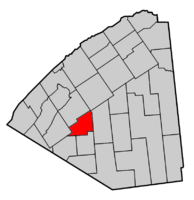
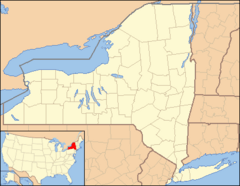
Map highlighting Hermon's location within St. Lawrence County.
|
|
| Country | United States |
| State | New York |
| County | St. Lawrence |
| Area | |
| • Total | 54.23 sq mi (140.44 km2) |
| • Land | 53.15 sq mi (137.65 km2) |
| • Water | 1.08 sq mi (2.80 km2) 1.38% |
| Population
(2020)
|
|
| • Total | 1,074 |
| • Estimate
(2016)
|
1,072 |
| • Density | 19.805/sq mi (7.647/km2) |
| Time zone | UTC-5 (Eastern (EST)) |
| • Summer (DST) | UTC-4 (EDT) |
| FIPS code | 36-089-34176 |
Hermon is a small town located in St. Lawrence County, New York, in the United States. In 2020, about 1,074 people lived there.
The town of Hermon is named after Mount Hermon. This mountain is found in Israel and Syria. Hermon is in the south-central part of St. Lawrence County. It is southwest of a larger place called Canton. The town also contains a smaller area called a hamlet, which is also named Hermon.
Contents
History of Hermon
Early Settlers
The first person to settle in the Hermon area was James Taylor. He arrived around the year 1805. During the War of 1812, many families living in the area had to leave for safety. Later, in 1818, the first saw mill was built on Elm Creek. A saw mill is a place where logs are cut into lumber.
How Hermon Got Its Name
The town was officially created in 1830. It was first called the "Town of Depeau." This name came from parts of two other towns: De Kalb and Edwards.
However, there was already another place named after Francis Depeau. So, in 1834, the town's name was changed to Hermon. This new name came from a post office already in the town. In 1852, Hermon became the size it is today. A small part of its land was moved to the town of Edwards.
The community of Hermon itself became a separate village in 1887. But this village was later dissolved in 2016.
Geography of Hermon
Hermon covers a total area of about 54.2 square miles. This is about 140.4 square kilometers. Most of this area is land. About 53.4 square miles (138.4 square kilometers) is land. The rest, about 0.8 square miles (1.9 square kilometers), is water.
Who Lives in Hermon?
| Historical population | |||
|---|---|---|---|
| Census | Pop. | %± | |
| 1830 | 668 | — | |
| 1840 | 1,271 | 90.3% | |
| 1850 | 1,690 | 33.0% | |
| 1860 | 1,690 | 0.0% | |
| 1870 | 1,702 | 0.7% | |
| 1880 | 1,634 | −4.0% | |
| 1890 | 1,521 | −6.9% | |
| 1900 | 1,542 | 1.4% | |
| 1910 | 1,526 | −1.0% | |
| 1920 | 1,505 | −1.4% | |
| 1930 | 1,356 | −9.9% | |
| 1940 | 1,147 | −15.4% | |
| 1950 | 1,350 | 17.7% | |
| 1960 | 1,255 | −7.0% | |
| 1970 | 1,087 | −13.4% | |
| 1980 | 1,083 | −0.4% | |
| 1990 | 1,041 | −3.9% | |
| 2000 | 1,069 | 2.7% | |
| 2010 | 1,108 | 3.6% | |
| 2020 | 1,074 | −3.1% | |
| U.S. Decennial Census | |||
In 2020, the census counted 1,074 people living in Hermon. There were 419 households. A household is a group of people living in the same home.
About 24% of the people in Hermon were under 18 years old. About 22.3% were 65 years old or older. The average age of people in Hermon was 39 years.
Places in Hermon
Here are some of the communities and locations you can find within the town of Hermon:
- Fairbanks Corners – This place is on the eastern edge of the town. You can find it on County Road 21.
- Hermon – This is a small community, or hamlet. It is in the northern part of the town on County Road 17. It used to be a village.
- Kents Corners – This is another hamlet. It is southwest of the Hermon hamlet. You can find it where County Roads 19 and 20 meet.
- Marshville – This hamlet is south of the Hermon hamlet. It was named after an early settler, Horatio Marsh.
- Trout Lake – This is a lake located in the southern part of the town.
See also
 In Spanish: Hermon (Nueva York) para niños
 | Aaron Henry |
 | T. R. M. Howard |
 | Jesse Jackson |


