De Peyster, New York facts for kids
Quick facts for kids
DePeyster, New York
|
|
|---|---|

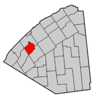
Map highlighting De Peyster's location within St. Lawrence County.
|
|
| Country | United States |
| State | New York |
| County | St. Lawrence |
| Area | |
| • Total | 45.10 sq mi (116.80 km2) |
| • Land | 42.93 sq mi (111.18 km2) |
| • Water | 2.17 sq mi (5.62 km2) |
| Elevation | 308 ft (94 m) |
| Population
(2020)
|
|
| • Total | 1,023 |
| • Density | 24.25/sq mi (9.36/km2) |
| Time zone | UTC-5 (Eastern (EST)) |
| • Summer (DST) | UTC-4 (EDT) |
| FIPS code | 36-20335 |
| GNIS feature ID | 0978898 |
DePeyster is a small town located in St. Lawrence County, New York, United States. In 2020, about 1,023 people lived there. The town gets its name from Frederic de Peyster, who owned land in the area.
Contents
History of DePeyster
The first people started settling in the DePeyster area around 1802.
The town of DePeyster was officially created in 1825. It was formed from parts of two other towns: DeKalb and Oswegatchie. The town was almost named "Stilwell" after a well-known resident, Smith Stilwell. However, he thought that one of the landowners might give money to the town if it was named after them. So, they contacted Frederic de Peyster, and his name was chosen for the new town.
Famous People from DePeyster
- Newton Martin Curtis – He was born in DePeyster. He was a brave soldier who received the Medal of Honor. He also worked as a postmaster, a high-ranking army officer (brigadier general), and a customs inspector.
- Patty Ritchie – She grew up in DePeyster. She later became a New York State Senator, which means she helped make laws for the state.
Geography of DePeyster
DePeyster covers a total area of about 45.1 square miles (116.8 square kilometers). Most of this area is land, with a smaller part being water.
The Oswegatchie River forms the northeast border of the town. Black Lake is along the northwestern border. A smaller lake called Mud Lake is found in the southwest part of the town. Beaver Creek marks the southeastern border.
Two main roads cross the town. New York State Route 812 goes through the northern part. New York State Route 184 runs from the northeast to the southwest.
Population of DePeyster
| Historical population | |||
|---|---|---|---|
| Census | Pop. | %± | |
| 1830 | 814 | — | |
| 1840 | 1,074 | 31.9% | |
| 1850 | 906 | −15.6% | |
| 1860 | 1,249 | 37.9% | |
| 1870 | 1,138 | −8.9% | |
| 1880 | 1,194 | 4.9% | |
| 1890 | 947 | −20.7% | |
| 1900 | 936 | −1.2% | |
| 1910 | 907 | −3.1% | |
| 1920 | 806 | −11.1% | |
| 1930 | 805 | −0.1% | |
| 1940 | 768 | −4.6% | |
| 1950 | 642 | −16.4% | |
| 1960 | 759 | 18.2% | |
| 1970 | 769 | 1.3% | |
| 1980 | 917 | 19.2% | |
| 1990 | 913 | −0.4% | |
| 2000 | 936 | 2.5% | |
| 2010 | 998 | 6.6% | |
| 2020 | 1,023 | 2.5% | |
In 2000, there were 936 people living in DePeyster. There were 272 households, which means 272 groups of people living together. About 42.6% of these households had children under 18 living with them.
The population was spread out by age. About 37.3% of the people were under 18 years old. The average age in the town was 29 years.
Places in DePeyster
- DePeyster – This is the main village, or hamlet, of the town. It is located in the northern part, along County Road 10.
- Kokomo Corners – You can find this spot west of the DePeyster village on NY-184.
- Lower Big Bay – This location is right on the edge of Black Lake.
See also
 In Spanish: De Peyster para niños
 | Laphonza Butler |
 | Daisy Bates |
 | Elizabeth Piper Ensley |


