Norfolk, New York facts for kids
Quick facts for kids
Norfolk, New York
|
|
|---|---|

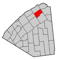
Map highlighting Norfolk's location within St. Lawrence County.
|
|
| Country | United States |
| State | New York |
| County | St. Lawrence |
| Settled | 1809 |
| Created | 1823 |
| Area | |
| • Total | 57.74 sq mi (149.55 km2) |
| • Land | 56.74 sq mi (146.96 km2) |
| • Water | 1.00 sq mi (2.60 km2) |
| Population
(2020)
|
|
| • Total | 4,453 |
| • Density | 78.48/sq mi (30.30/km2) |
| FIPS code | 36-089-51330 |
Norfolk is a town in St. Lawrence County, New York. It is located in the northern part of the county, just north of Potsdam. In 2020, the town had a population of 4,453 people.
Contents
Exploring Norfolk's Past
How Norfolk Began
The area that is now Norfolk was first settled around 1809. The town itself was officially created in 1823. It was formed from a part of the Town of Louisville.
Changes to Town Borders
Over time, Norfolk's borders changed a few times. In 1869, some land was given back to Louisville. Also in 1869, a part of the Town of Stockholm was added to Norfolk. A small area was lost when "Raquetteville" became the Village of Potsdam Junction in 1869, which later changed its name to Norwood in 1875.
Historic Landmarks
The Hepburn Library is an important building in Norfolk. It was added to the National Register of Historic Places in 1969. This means it is recognized as a place with special historical importance.
Famous People from Norfolk
Many notable individuals have connections to Norfolk. Here are a few:
- Calvin H. Robbins (1840-1900) was a doctor and a state representative in Minnesota.
- William Pierce Rogers (1913–2001) held two very important jobs in the United States government: U.S. Attorney General and U.S. Secretary of State.
- Horace Adolphus Taylor (1837–1910) was a state senator in Wisconsin and led the Republican Party of Wisconsin.
Norfolk's Landscape and Location
Land and Water Area
Norfolk covers a total area of about 57.7 square miles (149.5 square kilometers). Most of this area, about 56.7 square miles (147.0 square kilometers), is land. The remaining 2.0 square miles (2.6 square kilometers) is water.
Rivers and Roads
The Raquette River flows through the northern part of the town, moving towards the east. Several main roads help people travel through Norfolk. New York State Route 56 runs north and south. New York State Route 310 has its eastern end in Raymondville. New York State Route 420 runs alongside the eastern edge of the town.
Population of Norfolk
| Historical population | |||
|---|---|---|---|
| Census | Pop. | %± | |
| 1830 | 1,309 | — | |
| 1840 | 1,728 | 32.0% | |
| 1850 | 1,753 | 1.4% | |
| 1860 | 2,329 | 32.9% | |
| 1870 | 2,441 | 4.8% | |
| 1880 | 2,471 | 1.2% | |
| 1890 | 2,024 | −18.1% | |
| 1900 | 1,911 | −5.6% | |
| 1910 | 2,938 | 53.7% | |
| 1920 | 3,066 | 4.4% | |
| 1930 | 3,047 | −0.6% | |
| 1940 | 3,427 | 12.5% | |
| 1950 | 3,481 | 1.6% | |
| 1960 | 4,590 | 31.9% | |
| 1970 | 4,701 | 2.4% | |
| 1980 | 4,992 | 6.2% | |
| 1990 | 4,258 | −14.7% | |
| 2000 | 4,565 | 7.2% | |
| 2010 | 4,668 | 2.3% | |
| 2020 | 4,453 | −4.6% | |
| U.S. Decennial Census | |||
In 2000, there were 4,565 people living in Norfolk. These people lived in 1,803 households, with 1,280 of them being families. On average, there were about 2.53 people per household.
About 31.7% of households had children under 18 living with them. Many households, 55.1%, were married couples living together. The population was spread out in terms of age, with 25.2% being under 18 years old. The median age in the town was 38 years.
Places in Norfolk
Norfolk includes several smaller communities and locations:
- Dishaw – A small community located at the northern border of the town.
- Grantville – A community in the northern part of Norfolk, just north of Plumbrook.
- Marble Hill – An elevated area located east of the main Norfolk village.
- Norfolk – This is the main community or hamlet of Norfolk. It's north of Norwood on NY-56 and was where the first settlers arrived.
- Norwood – The northern part of the village of Norwood is actually located within the southwestern section of Norfolk.
- Plumbrook – A community in the eastern part of the town, found on County Route 38 (Plum Brook Road).
- Raymondville – This community is north of the Norfolk hamlet on NY-56, near the western town line and the Raquette River. It used to be called "Racketon." The Raymondville Parabolic Bridge is a historic bridge here, listed on the National Register of Historic Places in 1984.
- Yaleville – A community south of the Norfolk hamlet on NY-56, also near the Raquette River.
See also
 In Spanish: Norfolk (Nueva York) para niños
 | Delilah Pierce |
 | Gordon Parks |
 | Augusta Savage |
 | Charles Ethan Porter |


