Gouverneur, New York facts for kids
Quick facts for kids
Gouverneur
|
|
|---|---|
| Town of Gouverneur | |

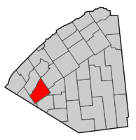
Map highlighting Gouverneur's location within St. Lawrence County.
|
|
| Country | United States |
| State | New York |
| County | St. Lawrence |
| Named for | Gouverneur Morris |
| Area | |
| • Total | 72.4 sq mi (187.6 km2) |
| • Land | 71.5 sq mi (185.3 km2) |
| • Water | 0.9 sq mi (2.3 km2) |
| Elevation | 440 ft (134 m) |
| Population
(2020)
|
|
| • Total | 6,551 |
| Time zone | UTC-5 (Eastern (EST)) |
| • Summer (DST) | UTC-4 (EDT) |
| FIPS code | 36-29597 |
| GNIS feature ID | 0976353 |
Gouverneur (pronounced GUH-vər-nər) is a town located in St. Lawrence County, New York, United States. In 2020, about 6,551 people lived here. This number was a bit lower than the 7,085 people counted in 2010. The town gets its name from Gouverneur Morris, an important statesman and landowner.
The Town of Gouverneur also includes a smaller area called the Village of Gouverneur. The town is located near the southwestern edge of St. Lawrence County. It is southwest of Canton, which is the main town of the county.
Contents
History of Gouverneur
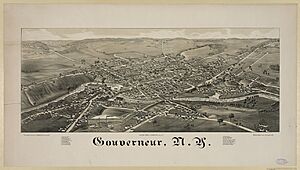
The area where Gouverneur is now located was first settled around the year 1805.
How Gouverneur Was Formed
The Town of Gouverneur was officially created in 1810. It was made from a part of another area called the Town of Oswegatchie. Before that, this area was known as "Town of Cambria."
Growth and Challenges
Like many other settlements in the county, Gouverneur's growth slowed down during the War of 1812. However, the town quickly started growing again after the war ended.
In 1850, the community of Gouverneur became its own separate village. This meant it had its own local government.
Local Economy
The town's economy was partly based on mining. People dug for valuable minerals like marble, talc, and zinc in the area.
Historic Buildings
The United States Post Office building in Gouverneur is quite old and special. It was added to the National Register of Historic Places in 1989, which means it's an important historical site.
Geography of Gouverneur
The town of Gouverneur covers a total area of about 72.4 square miles (187.6 square kilometers). Most of this area, about 71.5 square miles (185.3 square kilometers), is land. The rest, about 0.9 square miles (2.3 square kilometers), is water.
The Oswegatchie River
The Oswegatchie River flows through the town. It's interesting because it flows in two different directions within the town. In the southern part, it flows westward, and in the northern part, it flows eastward.
Main Roads and Highways
Several important roads meet in the Village of Gouverneur. These include U.S. Route 11, New York State Route 58, and New York State Route 812. Parts of NY-58 and NY-812 join together southwest of the village. Also, US-11 and NY-812 join together northeast of the village.
Population and People
The population of Gouverneur has changed over the years.
- In 1820, there were 765 people.
- By 1900, the population grew to 5,915.
- In 2000, there were 7,418 people living in the town.
- In 2020, the population was 6,551.
Households and Families
In 2000, there were 2,484 households in Gouverneur. About 34.8% of these households had children under 18 living with them. Many households, 50.7%, were married couples living together.
Age Groups
The people in Gouverneur come from different age groups.
- About 24.5% of the population was under 18 years old.
- About 33.8% were between 25 and 44 years old.
- About 11.7% were 65 years old or older.
The average age in the town was 34 years.
Communities and Locations in Gouverneur
The Town of Gouverneur includes several smaller communities and places:
- Elmdale – A small community in the northwestern part of the town. It is located on NY-58 and by the Oswegatchie River.
- Gouverneur – This is the main village within the town. It is on US-11, near the Oswegatchie River and the eastern town line.
- Halls Corners – A small community in the northern part of the town, located south of North Gouverneur.
- Little Bow – A small community found northwest of the main Gouverneur village.
- Natural Dam – A community located on NY-58, west of Gouverneur village. This place is named after a large rock that partly blocks the Oswegatchie River. Gouverneur Morris once had a summer home here.
- North Gouverneur – A community in the northern part of the town, west of County Road 11.
- Reservoir Hill – A higher area located near the town line, east of Gouverneur village.
- Staplin Corners – A small community in the northern part of the town, north of North Gouverneur.
Notable People from Gouverneur
Many interesting people have come from Gouverneur:
- Phil Hanlon (born 1955) – A mathematician who used to be the president of Dartmouth College.
- Brian Leonard (born 1984) – A former professional football player who played as a running back for the Tampa Bay Buccaneers.
- Edward John Noble (1882–1958) – The person who helped create and sell Life Savers candies.
- Thomas Lee Pangle (born 1944) – A political scientist, someone who studies politics and government.
- William R. Rowley (1824–1886) – A general who fought in the American Civil War.
- Lillian Tait Sheldon (1865–1925) – A talented composer who wrote music.
- Tudi Wiggins (1935–2006) – A Canadian actress known for her roles in TV shows.
- James Franklin Wiley – A person who was a member of the Wisconsin State Senate.
See also
 In Spanish: Gouverneur para niños
 | Shirley Ann Jackson |
 | Garett Morgan |
 | J. Ernest Wilkins Jr. |
 | Elijah McCoy |


