Macomb, New York facts for kids
Quick facts for kids
Macomb, New York
|
|
|---|---|

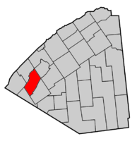
Map highlighting Macomb's location within St. Lawrence County.
|
|
| Country | United States |
| State | New York |
| County | St. Lawrence |
| Area | |
| • Total | 63.15 sq mi (163.55 km2) |
| • Land | 60.72 sq mi (157.26 km2) |
| • Water | 2.43 sq mi (6.29 km2) |
| Elevation | 302 ft (92 m) |
| Population
(2020)
|
|
| • Total | 912 |
| • Density | 14.61/sq mi (5.64/km2) |
| Time zone | UTC-5 (Eastern (EST)) |
| • Summer (DST) | UTC-4 (EDT) |
| FIPS code | 36-44391 |
| GNIS feature ID | 0979181 |
Macomb is a small town located in St. Lawrence County, New York, in the United States. In 2020, about 912 people lived here. The town is named after Alexander Macomb, who once owned a very large amount of land in northern New York. This land was known as Macomb's Purchase.
The Town of Macomb is in the northwestern part of St. Lawrence County. It is located northwest of the village of Gouverneur.
History of Macomb
The first settlers arrived in the Macomb area after 1810. However, there were signs like old trench enclosures and hearths. These suggest that Native American people lived in the area long before the European settlers arrived.
The town of Macomb was officially formed in 1841. It was created from parts of two nearby towns: Gouverneur and Morristown. A year later, in 1842, a small piece of the Town of Hammond was also added to Macomb.
In the early days, mining was an important activity in Macomb. The St. Lawrence Lead Mining Company operated nearby.
Geography of Macomb
Macomb covers a total area of about 63.2 square miles (163.55 square kilometers). Most of this area, about 61.2 square miles (157.26 square kilometers), is land. The rest, about 1.9 square miles (6.29 square kilometers), is water.
The northwestern part of the town is next to Black Lake. This lake forms the northern border of the town. Beaver Creek marks the southeastern border of Macomb.
New York State Route 58 is a main road that runs north and south through the town. It crosses New York State Route 184 at a place called Popes Mills.
Population and People
| Historical population | |||
|---|---|---|---|
| Census | Pop. | %± | |
| 1850 | 1,197 | — | |
| 1860 | 1,816 | 51.7% | |
| 1870 | 1,673 | −7.9% | |
| 1880 | 1,731 | 3.5% | |
| 1890 | 1,415 | −18.3% | |
| 1900 | 1,374 | −2.9% | |
| 1910 | 1,168 | −15.0% | |
| 1920 | 1,055 | −9.7% | |
| 1930 | 953 | −9.7% | |
| 1940 | 891 | −6.5% | |
| 1950 | 848 | −4.8% | |
| 1960 | 881 | 3.9% | |
| 1970 | 813 | −7.7% | |
| 1980 | 816 | 0.4% | |
| 1990 | 790 | −3.2% | |
| 2000 | 846 | 7.1% | |
| 2010 | 906 | 7.1% | |
| 2020 | 912 | 0.7% | |
According to the census from the year 2000, there were 846 people living in Macomb. These people lived in 310 households, and 226 of these were families. The population density was about 13.8 people per square mile.
Most of the people in Macomb were White (about 97.75%). There were also small numbers of Native American and Asian residents. A small percentage of people were of Hispanic or Latino background.
About 35.2% of the households had children under 18 living with them. Many households (61.0%) were married couples living together. The average household had about 2.73 people.
The population was spread out across different age groups. About 27.2% of the people were under 18 years old. The median age in the town was 37 years.
Places in Macomb
Here are some interesting communities and locations you can find in the Town of Macomb:
- Apple Island – This is a small island located at the southwestern end of Black Lake.
- Booths Island – Another small island found in Black Lake, close to the northwestern part of Macomb.
- Brasie Corners – A small hamlet (a tiny village) located on NY-58 in the southern part of the town.
- Fish Creek Wildlife Management Area – This is a special area set aside for nature and wildlife, located south of Black Lake.
- Grindstone Bay – A bay found at the southwestern end of Black Lake.
- Hickory Lake – A lake situated in the eastern corner of the town.
- Jennies Island – A small island in Black Lake, also near the northwestern part of Macomb.
- Mitchell Bay – A small bay on Black Lake, close to the northwestern part of Macomb.
- Pierces Corners – A location near the southeastern town line, where County Roads 7 and 10 meet.
- Pleasant Lake – A lake in the southern part of the town, just south of Brasie Corners.
- Pope Mills – A hamlet in the northern part of the town. It's where NY-58 and 184 intersect. This community was named after an early settler named Timothy Pope.
- Ruby Corner – A hamlet located near the northwestern town line on NY-58, south of Black Lake.
- Upper Big Bay – A small bay on Black Lake.
- Yellow Lake – The eastern end of this lake touches the western town line.
See also
 In Spanish: Macomb (Nueva York) para niños
 | Tommie Smith |
 | Simone Manuel |
 | Shani Davis |
 | Simone Biles |
 | Alice Coachman |


