Hopkinton, New York facts for kids
Quick facts for kids
Hopkinton, New York
|
|
|---|---|

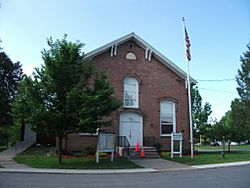
Town Court, May 2011
|
|
| Motto(s):
A Nice Place To Come Home To
|
|

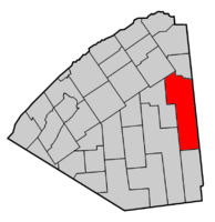
Map highlighting Hopkinton's location within St. Lawrence County.
|
|
| Country | United States |
| State | New York |
| County | St. Lawrence |
| Area | |
| • Total | 187.04 sq mi (484.44 km2) |
| • Land | 185.34 sq mi (480.03 km2) |
| • Water | 1.70 sq mi (4.41 km2) |
| Elevation | 1,273 ft (388 m) |
| Population
(2020)
|
|
| • Total | 1,105 |
| • Density | 5.9/sq mi (2.3/km2) |
| Time zone | UTC-5 (Eastern (EST)) |
| • Summer (DST) | UTC-4 (EDT) |
| FIPS code | 36-35595 |
| GNIS feature ID | 0979075 |
Hopkinton is a small town in St. Lawrence County, New York, United States. In 2020, about 1,105 people lived there. The town is named after Roswell Hopkins, who was an early settler and a government official.
The Town of Hopkinton is located in the southeast part of St. Lawrence County. It is near other towns like Parishville and Lawrence. The town sits at the base of the Adirondack Mountains.
Contents
Exploring Hopkinton's Past
The first people to settle in Hopkinton arrived around 1802. This made Hopkinton the fifth town in Saint Lawrence County. The town was named after its founder, Roswell Hopkins. It was officially created on March 2, 1805, from a part of Massena town.
Back then, Hopkinton was much bigger than it is today. Over time, parts of it were used to form new towns. These included Russell (in 1807), Parishville (in 1814), Lawrence (in 1828), and Piercefield (in 1900).
In February 1814, during the War of 1812, British soldiers raided the village. They took about 300 barrels of flour that belonged to the U.S. government.
Discovering Hopkinton's Geography
Hopkinton covers a total area of about 187 square miles (484 square kilometers). Most of this area is land, with a small part being water.
The eastern border of the town is also the border of Franklin County. A large part of Hopkinton, especially the southern section, is located inside the Adirondack Park. This area is known for its less developed, natural beauty.
The St. Regis River flows through the northern part of the town. This river is an important natural feature.
Several main roads cross through Hopkinton. New York State Route 11B and New York State Route 72 meet near Hopkinton village. New York State Route 458 also connects with NY-11B west of Nicholville.
Population Changes in Hopkinton
| Historical population | |||
|---|---|---|---|
| Census | Pop. | %± | |
| 1810 | 372 | — | |
| 1820 | 581 | 56.2% | |
| 1830 | 827 | 42.3% | |
| 1840 | 1,147 | 38.7% | |
| 1850 | 1,476 | 28.7% | |
| 1860 | 1,990 | 34.8% | |
| 1870 | 1,907 | −4.2% | |
| 1880 | 1,922 | 0.8% | |
| 1890 | 1,832 | −4.7% | |
| 1900 | 2,521 | 37.6% | |
| 1910 | 1,469 | −41.7% | |
| 1920 | 1,244 | −15.3% | |
| 1930 | 1,046 | −15.9% | |
| 1940 | 1,044 | −0.2% | |
| 1950 | 935 | −10.4% | |
| 1960 | 1,032 | 10.4% | |
| 1970 | 884 | −14.3% | |
| 1980 | 1,064 | 20.4% | |
| 1990 | 957 | −10.1% | |
| 2000 | 1,020 | 6.6% | |
| 2010 | 1,077 | 5.6% | |
| 2020 | 1,105 | 2.6% | |
| U.S. Decennial Census | |||
The population of Hopkinton has changed over the years. In 2000, there were 1,020 people living in the town. By 2020, the population had grown slightly to 1,105 people.
Most people in Hopkinton are White. A small number of people are Native American or African American. About 0.59% of the population is Hispanic or Latino.
In 2000, about 33.6% of households had children under 18 living with them. The average household had about 2.62 people. The median age in the town was 36 years old. This means half the people were younger than 36, and half were older.
Communities and Places to See
Hopkinton has several small communities and interesting spots.
Local Communities
- Catherineville – A small village located near the western border of the town.
- Fort Jackson – A village found near the northern town line. It started around 1814 when a mill was built on the St. Regis River.
- Hopkinton – This is the main village in the town. It is in the northwestern part of the town. Roswell Hopkins built a mill here around 1803. The Hopkinton Green Historic District is a historic area listed in 2013.
- Lake Ozonia – A village located at the northern end of Lake Ozonia.
- Nicholville – A village on the northern town line. Most of this community is actually in the Town of Lawrence.
Points of Interest
- Amber Lake – A small lake in the southern part of Hopkinton.
- Jordan Lake – Another small lake located in the southern part of the town.
- Lake Ozonia – A larger lake near the eastern town line, inside the Adirondack Park. It was once called "Trout Lake."
- Sylvan Falls – A beautiful waterfall on the West Branch of the St. Regis River. The water drops about 20 feet.
- Hopkinton Historical Museum – This museum is in a restored Victorian house on the Village Green. It tells the story of Hopkinton's past.
- Hopkinton Library - The local library for the Town of Hopkinton.
See also
 In Spanish: Hopkinton (Nueva York) para niños
 | Kyle Baker |
 | Joseph Yoakum |
 | Laura Wheeler Waring |
 | Henry Ossawa Tanner |


