Pitcairn, New York facts for kids
Quick facts for kids
Pitcairn, New York
|
|
|---|---|

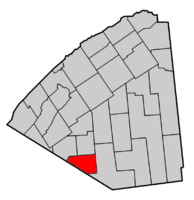
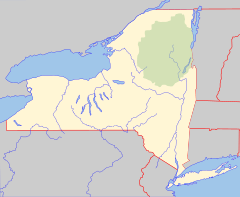
Map highlighting Pitcairn's location within St. Lawrence County.
|
|
| Country | United States |
| State | New York |
| County | St. Lawrence |
| Area | |
| • Total | 59.45 sq mi (153.99 km2) |
| • Land | 58.52 sq mi (151.56 km2) |
| • Water | 0.94 sq mi (2.43 km2) |
| Elevation | 984 ft (300 m) |
| Population
(2020)
|
|
| • Total | 790 |
| • Density | 14.03/sq mi (5.42/km2) |
| Time zone | UTC-5 (Eastern (EST)) |
| • Summer (DST) | UTC-4 (EDT) |
| FIPS code | 36-58266 |
| GNIS feature ID | 0979369 |
Pitcairn is a small town in St. Lawrence County, New York, United States. In 2010, about 846 people lived there. The town is named after Joseph Pitcairn, who owned land there a long time ago and was a diplomat.
You can find the Town of Pitcairn in the southwestern part of St. Lawrence County. It's located south of the village of Canton.
Contents
Pitcairn's Early Days
People started settling in the Pitcairn area around 1825. They built their homes near Portaferry Lake.
The town of Pitcairn was officially created in 1836. It was formed using parts of two other towns: Edwards and Fowler.
Exploring Pitcairn's Geography
The United States Census Bureau says that Pitcairn covers about 59.5 square miles (154 square kilometers). Most of this area, about 59.0 square miles (153 square kilometers), is land. The rest, about 0.5 square miles (1.3 square kilometers), is water.
The southern border of Pitcairn touches Lewis County. A part of the town is also inside the beautiful Adirondack Park.
Two important roads, New York State Route 3 and New York State Route 812, meet near the southern edge of the town.
Who Lives in Pitcairn?
| Historical population | |||
|---|---|---|---|
| Census | Pop. | %± | |
| 1840 | 396 | — | |
| 1850 | 503 | 27.0% | |
| 1860 | 577 | 14.7% | |
| 1870 | 667 | 15.6% | |
| 1880 | 790 | 18.4% | |
| 1890 | 1,108 | 40.3% | |
| 1900 | 902 | −18.6% | |
| 1910 | 316 | −65.0% | |
| 1920 | 646 | 104.4% | |
| 1930 | 570 | −11.8% | |
| 1940 | 521 | −8.6% | |
| 1950 | 569 | 9.2% | |
| 1960 | 647 | 13.7% | |
| 1970 | 676 | 4.5% | |
| 1980 | 792 | 17.2% | |
| 1990 | 751 | −5.2% | |
| 2000 | 783 | 4.3% | |
| 2010 | 846 | 8.0% | |
| 2020 | 790 | −6.6% | |
| U.S. Decennial Census | |||
In 2000, a census counted 783 people living in Pitcairn. These people lived in 295 households, and 233 of these were families. The town had about 13.3 people per square mile (5.1 people per square kilometer).
Most people in Pitcairn were White (99.36%). A small number were Asian (0.26%) or from other races (0.38%). About 0.64% of the population was Hispanic or Latino.
About 39% of households had children under 18 living with them. Most households (64.7%) were married couples. The average household had 2.65 people, and the average family had 2.92 people.
The population was spread out by age. About 27.2% were under 18, and 9.7% were 65 or older. The average age in town was 37 years.
Communities and Places in Pitcairn
- Backus – This is a small hamlet located south of Pitcairn village.
- Baldface Hill – You can find this elevated area north of Pitcairn village.
- Copper Hill – Another elevated area, located north of Baldface Hill.
- Geers Corners – A hamlet in the southwestern part of the town, found along NY-812.
- Jayville – This hamlet is in the southeastern part of the town, east of Kalurah.
- Kalurah – Another hamlet located in the southeastern part of the town.
- East Pitcairn – A hamlet in the northeastern part of the town, on County Road 23.
- Pitcairn – This is the main hamlet of Pitcairn, located in the central part of the town on NY-3.
- Portaferry Lake – A small lake situated near the eastern border of the town.
See also
 In Spanish: Pitcairn (Nueva York) para niños
 | Janet Taylor Pickett |
 | Synthia Saint James |
 | Howardena Pindell |
 | Faith Ringgold |


