Pierrepont, New York facts for kids
Quick facts for kids
Pierrepont, New York
|
|
|---|---|

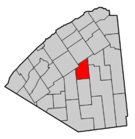
Map highlighting Pierrepont's location within St. Lawrence County.
|
|
| Country | United States |
| State | New York |
| County | St. Lawrence |
| Area | |
| • Total | 60.72 sq mi (157.26 km2) |
| • Land | 60.23 sq mi (156.00 km2) |
| • Water | 0.49 sq mi (1.26 km2) |
| Elevation | 922 ft (281 m) |
| Population
(2020)
|
|
| • Total | 2,523 |
| • Density | 41.89/sq mi (16.17/km2) |
| Time zone | UTC-5 (Eastern (EST)) |
| • Summer (DST) | UTC-4 (EDT) |
| FIPS code | 36-57771 |
| GNIS feature ID | 0979365 |
| Website | Official Town of Pierrepont official website: http://www.townofpierrepont.com |
Pierrepont is a small town and a hamlet (a small village) in St. Lawrence County, New York, United States. In 2020, about 2,523 people lived here. The town is named after Hezekiah Pierrepont, who owned a lot of land in the area long ago. The Town of Pierrepont is in the middle of the county, southeast of a village called Canton. There is also a small community called Pierrepont within the town. Be careful not to confuse it with Pierrepont Manor, which is in a different county, Jefferson County.
Contents
History of Pierrepont
The first European-American settlers arrived in Pierrepont around 1806 or 1807. Many of these early settlers came from New England after the American Revolutionary War.
The town of Pierrepont was officially created in 1818. It was formed from parts of two other towns: Russell and Potsdam. Over the years, parts of Pierrepont were used to create other towns. These included Fine in 1844, Clifton in 1868, and Clare in 1882.
Geography of Pierrepont
Pierrepont covers about 60.7 square miles (157.26 square kilometers). Most of this area is land, with a small part being water.
The Raquette River flows through the northeastern part of the town. This river is the longest in St. Lawrence County. It is also the third longest river in all of New York state.
Two main roads cross through Pierrepont. New York State Route 56 goes through the northeast. New York State Route 68 is a road that runs east to west.
Notable People from Pierrepont
Many interesting people have come from Pierrepont:
- Josephine Del Deo: An artist, activist, and writer.
- Edwin Atkins Merritt: He was a member of the New York State Assembly. He also served as Quartermaster General of the New York Militia.
- Edwin Albert Merritt: He was a U.S. Congressman, representing the area in the United States government.
- Irving Bacheller: A well-known author.
- Albert P. Crary: A scientist who studied the Earth's frozen regions, especially the poles.
Population of Pierrepont
| Historical population | |||
|---|---|---|---|
| Census | Pop. | %± | |
| 1820 | 235 | — | |
| 1830 | 749 | 218.7% | |
| 1840 | 1,430 | 90.9% | |
| 1850 | 1,459 | 2.0% | |
| 1860 | 2,267 | 55.4% | |
| 1870 | 2,391 | 5.5% | |
| 1880 | 2,494 | 4.3% | |
| 1890 | 1,954 | −21.7% | |
| 1900 | 1,885 | −3.5% | |
| 1910 | 1,628 | −13.6% | |
| 1920 | 1,425 | −12.5% | |
| 1930 | 1,379 | −3.2% | |
| 1940 | 1,312 | −4.9% | |
| 1950 | 1,192 | −9.1% | |
| 1960 | 1,523 | 27.8% | |
| 1970 | 1,726 | 13.3% | |
| 1980 | 2,207 | 27.9% | |
| 1990 | 2,375 | 7.6% | |
| 2000 | 2,674 | 12.6% | |
| 2010 | 2,589 | −3.2% | |
| 2020 | 2,523 | −2.5% | |
| U.S. Decennial Census | |||
In 2000, there were 2,674 people living in Pierrepont. These people lived in 1,039 households. About 744 of these households were families.
Most people living in Pierrepont are White (98.77%). A small number of people are African American, Native American, or Asian. Some people are of Hispanic or Latino background.
About 33.9% of households had children under 18 living with them. Many households (61.2%) were married couples living together. The average household had about 2.57 people.
The population includes people of all ages. About 25.9% were under 18 years old. About 10.4% were 65 years or older. The average age in the town was 38 years old.
Communities and Locations in Pierrepont
Pierrepont has several smaller communities and interesting spots:
- Austin's Corners – You can find this spot near the southern border of the town.
- Browns Bridge – This area is in the northeastern part of town, crossing the Raquette River. The bridge was rebuilt in 2021. It's a popular place for bridge jumping, and there's a dam nearby.
- Coney Island – This is a dead-end road in Hannawa Falls. From the 1920s to the 1940s, it was a small amusement park.
- Crary Mills – This small community is in the northwestern part of town. It sits where Pierrepont, Colton, and Canton meet. The Crary Mills Mighty Mall has small shops.
- Dean's Corners – This location is in the southwestern part of Pierrepont.
- Hannawa Falls – This community is in the eastern part of the town, along NY-56. It used to be called "Cox's Mill." Today, Hannawa Falls has stores, a post office, a fire department, and a restaurant.
- Hannawa Pond is a reservoir on the Raquette River. It's a great place for boating and swimming.
- The Gardner Cox House in Hannawa Falls is a historic building. It was added to the National Register of Historic Places in 1986.
- Moore's Corners – Another location in the southwestern part of the town.
- Pierrepont – This is the main hamlet, located on NY-68. The town hall and museum are here. The town also has its own fire department. The Pierrepont Town Buildings were listed on the National Register of Historic Places in 1982.
- Selleck's Corners – A location in the southeastern part of Pierrepont.
- Vebber Corners – This spot is in the southeastern part of town, south of Washburn Corners.
- Washburn Corners – A location in the eastern part of the town.
- West Pierrepont – A community in the southwestern part of the town.
- Willisville – A location in the eastern part of Pierrepont.
- Wilson Corners – This spot is in the southern part of the town, south of Washburn Corners.
- Postwood and 4-H – Postwood Park is a popular beach on the Raquette River. It used to have camping grounds. Next to Postwood is a large area called 4-H, which is now a popular spot for hiking.
See also
 In Spanish: Pierrepont (Nueva York) para niños
 | John T. Biggers |
 | Thomas Blackshear |
 | Mark Bradford |
 | Beverly Buchanan |


