
Wheatfield, New York facts for kids
Quick facts for kids
Wheatfield
|
|||
|---|---|---|---|
| Town of Wheatfield | |||
|
|||

Location in Niagara County and the state of New York.
|
|||

Wheatfield
Location in New York
|
|||
| Country | United States | ||
| State | New York | ||
| County | Niagara | ||
| Government | |||
| • Type | Town Council | ||
| Area | |||
| • Total | 28.59 sq mi (74.05 km2) | ||
| • Land | 27.91 sq mi (72.27 km2) | ||
| • Water | 0.69 sq mi (1.78 km2) | ||
| Elevation | 577 ft (176 m) | ||
| Population
(2010)
|
|||
| • Total | 18,117 | ||
| • Estimate
(2016)
|
18,284 | ||
| • Density | 655.22/sq mi (252.99/km2) | ||
| Time zone | UTC-5 (Eastern (EST)) | ||
| • Summer (DST) | UTC-4 (EDT) | ||
| ZIP codes |
14120, 14304, 14132
|
||
| Area code(s) | 716 | ||
| FIPS code | 36-81380 | ||
| GNIS feature ID | 0979632 | ||


Wheatfield is a town located in Niagara County, New York. In 2010, about 18,117 people lived here. The town got its name because a lot of wheat used to grow in its fields.
The Town of Wheatfield is found just east of the Niagara Falls International Airport.
Contents
Exploring Wheatfield's Past

The Town of Wheatfield was created in 1836. It was formed from a part of the Town of Niagara. Wheatfield is in the southwest part of Niagara County. It is surrounded by other towns like Lewiston and Cambria to the north. Pendleton is to the east. To the south are the City of North Tonawanda and the Niagara River. The City of Niagara Falls and Town of Niagara are to the west.
One of the first known settlers in the area was George N. Burger. He arrived in 1809 and built a log tavern. Joshua Pettit came in 1810 and also opened a tavern. Stephen Jacobs, a soldier from the Battle of Bunker Hill, settled here in 1817. He bought 196 acres (0.79 km2) of land.
William Vandervoorte settled in 1825. He planned to buy timber and open a business. In 1828, he finished the first public house, called the Niagara. He also bought 1,000 acres (4.0 km2) of land. He sold much of this land to immigrants from Prussia. He opened the first bank in 1836. The town's growth really picked up after the Erie Canal opened.
The first town meeting was held on June 6, 1836. It took place in a schoolhouse. The soil in Wheatfield is good for growing crops, especially wheat. This is why the town was named Wheatfield.
Starting in 1843, German immigrants began to settle here. They created communities like Bergholz and St. Johnsburg. Other communities included Walmore, Martinsville, and Gratwick. Martinsville and Gratwick are now part of North Tonawanda. Later, more communities grew around railroad stops and main roads.
In the 1920s, the River Road area became a successful farming region. It was home to "Wheatfield Farms." People built vacation cottages, beaches, and amusement parks along the river. Today, most of these have been replaced by homes.
During World War II, new industries came to Wheatfield. One of the biggest was Bell Aircraft. This company, founded by Larry Bell, made planes like the P-39 Airacobra. About 10% of all US aircraft during the war were made in Western New York by Bell. Later, Bell Aerospace made parts for space travel, including the Apollo Lunar Module propulsion system. The Bell facility closed in 1990. Now, it's a business complex, including a part of Lockheed Martin.
After the war, more businesses opened in Wheatfield. These included motels and restaurants for tourists. Some large companies were Carborundum and Demler Cider Mill. The Niagara Falls Air Reserve Station is a big employer in the town. The Summit Medical Campus also provides many jobs.
The town continued to grow as families moved in. New neighborhoods were built. The Summit Park Mall opened in 1972. It served people in Wheatfield and nearby areas. The mall closed in 2008 and is now being redeveloped.
Wheatfield has seen a lot of growth since the 1980s. Many new homes and business parks have been built. The population is now over 18,000 people. This means it is considered a "first class" town.
Understanding Wheatfield's Geography
Wheatfield covers about 28.6 square miles (74.05 km2). Most of this area, about 27.9 square miles (72.27 km2), is land. The rest, about 0.7 square miles (1.78 km2), is water.
The Niagara River forms part of the town's western border.
Neighboring Cities and Towns
Wheatfield shares its borders with several other places:
- City of North Tonawanda - to the south
- City of Niagara Falls - to the west
- Town of Niagara - to the west
- Town of Lewiston - to the northwest
- Town of Cambria - to the northeast
- Town of Pendleton - to the east
- Erie County, Town of Amherst - to the southeast
- Erie County, Town of Grand Island - to the southwest
Main Roads in Wheatfield
Several important highways run through the Town of Wheatfield:
 U.S. Route 62 (Niagara Falls Blvd.): This road goes north-south through the town.
 New York State Route 265 / New York State Route 384 (River Rd.): These roads run north-south along the Niagara River in the western part of town.
 New York State Route 425 (Shawnee Rd.): This road goes north-south through the town.
 New York State Route 429 (Ward Rd.): This road also runs north-south through the town.
People and Population in Wheatfield
| Historical population | |||
|---|---|---|---|
| Census | Pop. | %± | |
| 1840 | 1,057 | — | |
| 1850 | 2,659 | 151.6% | |
| 1860 | 3,484 | 31.0% | |
| 1870 | 3,406 | −2.2% | |
| 1880 | 4,390 | 28.9% | |
| 1890 | 4,015 | −8.5% | |
| 1900 | 1,926 | −52.0% | |
| 1910 | 1,792 | −7.0% | |
| 1920 | 1,884 | 5.1% | |
| 1930 | 2,212 | 17.4% | |
| 1940 | 3,077 | 39.1% | |
| 1950 | 4,720 | 53.4% | |
| 1960 | 8,008 | 69.7% | |
| 1970 | 9,722 | 21.4% | |
| 1980 | 9,609 | −1.2% | |
| 1990 | 11,125 | 15.8% | |
| 2000 | 14,086 | 26.6% | |
| 2010 | 18,117 | 28.6% | |
| 2020 | 18,638 | 2.9% | |
| U.S. Decennial Census | |||
Wheatfield is part of the larger Buffalo–Niagara Falls metropolitan area. In 2010, the town's population was 18,117 people.
According to the 2000 census, there were 14,086 people living in Wheatfield. Most residents were White (97.44%). About 32.3% of households had children under 18. The average household had 2.58 people. The average family had 3.04 people.
The median age in the town was 40 years old. About 23.5% of the population was under 18. About 15.8% were 65 or older. The median income for a household was $51,700. For families, it was $61,315.
Learning and Education
Wheatfield has a good number of schools. There are six public schools. There are also four private schools. These include St. Peter's Lutheran Church and School and St. John Lutheran School.
Well-Known People from Wheatfield
Some notable people have connections to Wheatfield:
- John Wayne Bobbitt: He graduated from Niagara Wheatfield Senior High School in 1985.
- Adam Clendening: An NHL hockey player. He grew up in Wheatfield, though he was born in Niagara Falls, New York.
- Lewis S. Payne: A businessman and politician. He was a Town Supervisor and later a New York State Senator. He was also a decorated Colonel in the Union Army during the American Civil War.
Communities and Places in Wheatfield
Here are some of the communities and important locations you can find in Wheatfield:
- Bergholz – A small community in the northwest part of town, close to the airport.
- Hoffman – A place on the eastern edge of the town.
- Nashville – A location on US-62 in the southeast part of town.
- Niagara Falls International Airport (IAG) – Part of this airport is in the northern area of the town.
- Sawyer – A small community on US-62, next to the City of North Tonawanda.
- Shawnee – A community on US-62 (Niagara Falls Boulevard).
- St. Johnsburg – A community near the center of the town on US-62.
- Walmore – A community in the northwest part of town on Lockport Road.
Former Communities of Wheatfield
- Martinsville (1836-1896): This community later became part of the City of North Tonawanda.
Images for kids
-
The official flag of Wheatfield, New York.
-
The official seal of Wheatfield, New York.
-
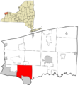
Map showing Wheatfield's location in Niagara County.
See also
 In Spanish: Wheatfield (Nueva York) para niños
