
Radcliffe Line facts for kids

The Radcliffe Line was a special border drawn in 1947. It separated India from Pakistan when British rule in India ended. At that time, Pakistan also included what is now Bangladesh. This line divided the large region of Bengal into West Bengal (which became part of India) and East Bengal (which became East Pakistan, and later Bangladesh).
Contents
The Radcliffe Line: Drawing Borders in 1947
Sir Cyril Radcliffe was given the big job of drawing this new border. He had to divide a huge area of about 175,000 square miles (450,000 km2) where 88 million people lived. His goal was to divide the land fairly between the new countries.
The Radcliffe Line officially started on August 17, 1947. This was right after the Partition of India, which created India and Pakistan as independent nations.
Challenges of Drawing the Line
Drawing the Radcliffe Line was a very difficult task. There were many problems and challenges when the new border was put into place:
- The Chittagong Hill Tracts area had mostly Buddhist people. However, this area was given to East Pakistan (which is now Bangladesh).
- The Gurdaspur District had mostly Muslim people. But this area was given to India. This was partly to give India access to the region of Jammu and Kashmir.
- Sometimes, the line went right through villages. This meant one part of a village was in India and another part was in Pakistan.
- In some cases, the border even went through houses! Different rooms of the same house ended up in different countries.
- There was also a complicated situation with the Ferozpur District. This area had many Muslim people. Initially, it looked like it might go to Pakistan. However, a local ruler, the Maharaja of Bikaner, needed water from a river in Ferozpur for his desert state. He strongly argued for Ferozpur to be part of India. In the end, the entire Ferozpur District was given to India.
Images for kids
-
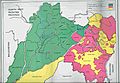
Districts of Punjab with Muslim (green) and non-Muslim (pink) majorities, as per 1941 census
-
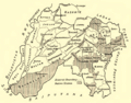
Pre-partition Punjab province
-
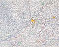
The Punjabi section of the Radcliffe Line
-
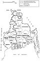
Radcliffe Line between West and East Bengal.


See also
 In Spanish: Línea Radcliffe para niños
