Yécora, Sonora facts for kids
Quick facts for kids
Yécora
|
|
|---|---|
| Country | Mexico |
| State | Sonora |
| Elevation | 5,171 ft (1,576 m) |
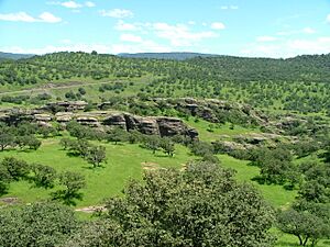
Yécora is a small, interesting town in the Mexican state of Sonora. It's also the name of the area around the town, called a municipality. About 3,171 people live in Yécora. This town is known for its unique climate and beautiful natural surroundings.
Contents
History of Yécora
How Yécora Got Its Name
In 1673, a Jesuit missionary named Alonso Victoria started a town here. He called it San Idelfonso of Yécora. Later, the town's name changed to La Trinidad. It became a Judicial District within the municipality of Sahuaripa.
On August 28, 1916, the Governor of Sonora, Adolfo de la Huerta, officially changed the town's name back to Yécora. The name Yécora comes from a town in northern Spain, in a region called the Basque Country. In the Basque language, the name is Iekora.
Geography of Yécora
Where is Yécora Located?
Yécora is located at a special spot with coordinates Latitude 28.3710 and Longitude -108.9269. It sits high up, at an elevation of about 5,173 feet (1,576 meters) above sea level.
The town is surrounded by different areas:
- To the east, it borders the state of Chihuahua.
- To the north, you'll find the municipalities of Sahuaripa and Southeast Rosario.
- To the west, it's next to the municipality of Suaqui Grande.
- To the northwest, it borders the municipality of Onavas.
Yécora covers a large area of about 1,279 square miles (3,312 square kilometers). This means it makes up about 1.79 percent of the entire state of Sonora.
Yécora's Unique Climate
Yécora has a special kind of weather called a subtropical highland climate. This means it has warm summers and mild winters. Sometimes, it even gets freezing temperatures.
What makes Yécora stand out is how much rain it gets. With 944 millimeters (about 37.2 inches) of rain each year, it's one of the wettest places in Sonora. Most of Sonora is quite dry! Also, because Yécora is so high up (1,576 meters or 5,171 feet above sea level), its temperatures are generally cooler than other parts of the state.
| Climate data for Yécora, Sonora (1981–2010), extremes (1967–present) | |||||||||||||
|---|---|---|---|---|---|---|---|---|---|---|---|---|---|
| Month | Jan | Feb | Mar | Apr | May | Jun | Jul | Aug | Sep | Oct | Nov | Dec | Year |
| Record high °C (°F) | 28.0 (82.4) |
33.5 (92.3) |
34.5 (94.1) |
40.5 (104.9) |
39.0 (102.2) |
42.5 (108.5) |
38.0 (100.4) |
36.5 (97.7) |
38.5 (101.3) |
34.0 (93.2) |
31.0 (87.8) |
30.5 (86.9) |
42.5 (108.5) |
| Mean daily maximum °C (°F) | 17.6 (63.7) |
18.3 (64.9) |
20.7 (69.3) |
24.4 (75.9) |
28.3 (82.9) |
31.0 (87.8) |
28.6 (83.5) |
28.0 (82.4) |
27.6 (81.7) |
24.7 (76.5) |
20.4 (68.7) |
17.8 (64.0) |
24.0 (75.2) |
| Daily mean °C (°F) | 7.0 (44.6) |
7.9 (46.2) |
9.8 (49.6) |
13.2 (55.8) |
17.1 (62.8) |
21.4 (70.5) |
21.7 (71.1) |
21.3 (70.3) |
19.9 (67.8) |
15.2 (59.4) |
9.9 (49.8) |
7.1 (44.8) |
14.3 (57.7) |
| Mean daily minimum °C (°F) | −3.6 (25.5) |
−2.6 (27.3) |
−1.1 (30.0) |
2.1 (35.8) |
5.9 (42.6) |
11.9 (53.4) |
14.9 (58.8) |
14.5 (58.1) |
12.3 (54.1) |
5.7 (42.3) |
−0.7 (30.7) |
−3.5 (25.7) |
4.7 (40.5) |
| Record low °C (°F) | −13.0 (8.6) |
−13.5 (7.7) |
−10.0 (14.0) |
−6.0 (21.2) |
−5.0 (23.0) |
3.5 (38.3) |
2.0 (35.6) |
2.0 (35.6) |
1.0 (33.8) |
−5.0 (23.0) |
−9.5 (14.9) |
−14.5 (5.9) |
−14.5 (5.9) |
| Average precipitation mm (inches) | 41.1 (1.62) |
41.3 (1.63) |
20.1 (0.79) |
11.5 (0.45) |
12.9 (0.51) |
68.9 (2.71) |
250.0 (9.84) |
251.0 (9.88) |
115.8 (4.56) |
51.1 (2.01) |
26.0 (1.02) |
54.3 (2.14) |
944.0 (37.17) |
| Average precipitation days (≥ 0.1 mm) | 3.8 | 3.2 | 2.0 | 1.4 | 1.8 | 6.8 | 20.1 | 18.6 | 9.9 | 3.9 | 2.4 | 3.4 | 77.3 |
| Average snowy days | 0.16 | 0.03 | 0.03 | 0 | 0 | 0 | 0 | 0 | 0 | 0 | 0 | 0.07 | 0.29 |
| Source 1: Servicio Meteorológico National | |||||||||||||
| Source 2: Colegio de Postgraduados | |||||||||||||
See also
 In Spanish: Yécora (Sonora) para niños
 | Delilah Pierce |
 | Gordon Parks |
 | Augusta Savage |
 | Charles Ethan Porter |


