
Administrative divisions of Mexico facts for kids
The United Mexican States (Spanish: Estados Unidos Mexicanos) is a federal republic. Think of it like a team of 32 players, where each player is a "federal entity." These include 31 states and one special area called the Federal District.
According to Mexico's Constitution of 1917, each state in the country is free and can make its own rules. This means every state has its own congress (like a mini-parliament) and its own constitution (a set of main laws). However, the Federal District, which is commonly known as Mexico City, is a bit different. It has some freedom, but not as much as the states. It has its own local Congress and government, and it serves as the capital city of Mexico.
Contents
How Mexico is Divided

The Federal District: Mexico City
The Federal District is a very important part of Mexico because it's where the national capital, Mexico City, is located. It's a huge and busy city! Even though it's called a "district," it works a lot like a state in many ways, but with some special rules because it's the capital.
| Entity | Official Name | Flag | Area | Population (2010) | Date of establishment |
|---|---|---|---|---|---|
| Ciudad de México | Distrito Federal |  |
1,485 km2 (573.4 sq mi) |
8,720,916 | 1824-11-18 |
The States of Mexico
Mexico has 31 states, and each one is unique! They all have their own capital cities, flags, and local governments. Just like in other federal countries, the states work together with the national government to make sure everything runs smoothly across the country.
Here's a list of the states, their capitals, and some other interesting facts:
| State | Official Name Estado Libre y Soberano de: |
Flag | Capital | Largest city | Area | Population (2010) | Order of Admission to Federation |
Date of Admission to Federation |
|---|---|---|---|---|---|---|---|---|
| Aguascalientes | Aguascalientes | Aguascalientes | Aguascalientes | 5,618 km2 (2,169 sq mi) | 1,184,996 | 24 | 1857-02-05 | |
| Baja California | Baja California | Mexicali | Tijuana | 71,446 km2 (27,585 sq mi) | 3,155,070 | 29 | 1952-01-16 | |
| Baja California Sur | Baja California Sur | La Paz | La Paz | 73,922 km2 (28,541 sq mi) | 637,026 | 31 | 1974-10-08 | |
| Campeche | Campeche | San Francisco de Campeche | San Francisco de Campeche | 57,924 km2 (22,365 sq mi) | 822,441 | 25 | 1863-04-29 | |
| Chiapas | Chiapas | Tuxtla Gutiérrez | Tuxtla Gutiérrez | 73,289 km2 (28,297 sq mi) | 4,796,580 | 19 | 1824-09-14 | |
| Chihuahua | Chihuahua | Chihuahua | Ciudad Juárez | 247,455 km2 (95,543 sq mi) | 3,406,465 | 18 | 1824-07-06 | |
| Coahuila1 4 | Coahuila de Zaragoza | Saltillo | Torreón | 151,563 km2 (58,519 sq mi) | 2,748,391 | 16 | 1824-05-07 | |
| Colima | Colima | Colima | Manzanillo | 5,625 km2 (2,172 sq mi) | 650,555 | 23 | 09-12-1856 | |
| Durango | Durango | Victoria de Durango | Victoria de Durango | 123,451 km2 (47,665 sq mi) | 1,632,934 | 17 | 1824-05-22 | |
| Guanajuato | Guanajuato | Guanajuato | León | 30,608 km2 (11,818 sq mi) | 5,486,372 | 2 | 1823-12-20 | |
| Guerrero | Guerrero | Chilpancingo de los Bravo |
Acapulco de Juárez | 63,621 km2 (24,564 sq mi) | 3,388,768 | 21 | 1849-10-27 | |
| Hidalgo | Hidalgo | Pachuca de Soto | Pachuca de Soto | 20,846 km2 (8,049 sq mi) | 2,665,018 | 26 | 1869-01-16 | |
| Jalisco | Jalisco | Guadalajara | Guadalajara | 78,599 km2 (30,347 sq mi) | 7,350,682 | 9 | 1823-12-23 | |
| México | México | Toluca de Lerdo | Ecatepec de Morelos | 22,357 km2 (8,632 sq mi) | 15,175,862 | 1 | 1823-12-20 | |
| Michoacán | Michoacán de Ocampo | Morelia | Morelia | 58,643 km2 (22,642 sq mi) | 4,351,037 | 5 | 1823-12-22 | |
| Morelos | Morelos | Cuernavaca | Cuernavaca | 4,893 km2 (1,889 sq mi) | 1,777,227 | 27 | 1869-04-17 | |
| Nayarit | Nayarit | Tepic | Tepic | 27,815 km2 (10,739 sq mi) | 1,084,979 | 28 | 1917-01-26 | |
| Nuevo León4 | Nuevo León | Monterrey | Monterrey | 64,220 km2 (24,800 sq mi) | 4,653,458 | 15 | 1824-05-07 | |
| Oaxaca | Oaxaca | Oaxaca de Juárez | Oaxaca de Juárez | 93,793 km2 (36,214 sq mi) | 3,801,962 | 3 | 1823-12-21 | |
| Puebla | Puebla | Puebla de Zaragoza | Puebla de Zaragoza | 34,290 km2 (13,240 sq mi) | 5,779,829 | 4 | 1823-12-21 | |
| Querétaro | Querétaro | Santiago de Querétaro | Santiago de Querétaro | 11,684 km2 (4,511 sq mi) | 1,827,937 | 11 | 1823-12-23 | |
| Quintana Roo | Quintana Roo | Chetumal | Cancún | 42,361 km2 (16,356 sq mi) | 1,325,578 | 30 | 1974-10-08 | |
| San Luis Potosí | San Luis Potosí | San Luis Potosí | San Luis Potosí | 60,983 km2 (23,546 sq mi) | 2,585,518 | 6 | 1823-12-22 | |
| Sinaloa | Sinaloa | Culiacán | Culiacán | 57,377 km2 (22,153 sq mi) | 2,767,761 | 20 | 1830-10-14 | |
| Sonora2 | Sonora | Hermosillo | Hermosillo | 179,503 km2 (69,306 sq mi) | 2,662,480 | 12 | 1824-01-10 | |
| Tabasco5 | Tabasco | Villahermosa | Villahermosa | 24,738 km2 (9,551 sq mi) | 2,238,603 | 13 | 1824-02-07 | |
| Tamaulipas4 | Tamaulipas | Ciudad Victoria | Reynosa | 80,175 km2 (30,956 sq mi) | 3,268,554 | 14 | 1824-02-07 | |
| Tlaxcala | Tlaxcala | Tlaxcala de Xicoténcatl | Vicente Guerrero | 3,991 km2 (1,541 sq mi) | 1,169,936 | 22 | 1856-12-09 | |
| Veracruz | Veracruz de Ignacio de la Llave |
Xalapa | Veracruz | 71,820 km2 (27,730 sq mi) | 7,643,194 | 7 | 1823-12-22 | |
| Yucatán3 | Yucatán | Mérida | Mérida | 39,612 km2 (15,294 sq mi) | 1,955,577 | 8 | 1823-12-23 | |
| Zacatecas | Zacatecas | Zacatecas | Zacatecas | 75,539 km2 (29,166 sq mi) | 1,490,668 | 10 | 1823-12-23 |
Notes:
- This state joined Mexico with the name Coahuila y Texas.
- This state joined Mexico with the name Estado de Occidente, also known as Sonora y Sinaloa.
- This state joined Mexico as the Federated Republic of Yucatán (English: Federated Republic of Yucatán). It was made up of the areas that are now Yucatan, Campeche, and Quintana Roo. It became independent in 1841 and rejoined Mexico in 1848.
- The states of Nuevo León, Tamaulipas, and Coahuila briefly tried to become independent in 1840 to form the República del Río Grande (English: Republic of the Rio Grande). However, their independence didn't last because their forces were defeated.
- The state of Tabasco left Mexico twice, once from February 13, 1841, to December 2, 1842, and again from November 9, 1846, to December 8 of the same year.
Images for kids
-
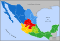
Typical (unofficial) regional grouping of the Mexican states.
-
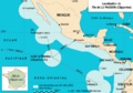
Location of Socorro Island and the rest of the Revillagigedo Archipelago, and extent of Mexico's western EEZ in the Pacific. The islands are part of Colima state, but under federal jurisdiction.


See also
 In Spanish: Organización territorial de México para niños
