Chilpancingo facts for kids
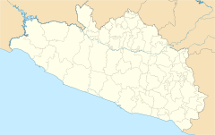
Chilpancingo (say: Cheel-pan-SEEN-go) is an important city in Mexico. It is the capital of the state of Guerrero. In 2010, about 187,251 people lived there.
The city is located in the Sierra Madre del Sur mountains, next to the Huacapa River. It is on a main road, Mexican Federal Highway 95, which links Acapulco and Mexico City. The city also has an airport.
Quick facts for kids
Chilpancingo, Guerrero
|
||
|---|---|---|
| Chilpancingo de los Bravo | ||
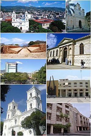
Above, from left to right: Downtown, Chilpancingo Francisco Assisi Church, Tehuacalco archaeological site, The Civic Plaza "First Congress of Anahuac", Chilpancingo Saint Mary Cathedral, Museo de Regional de Guerrero (Regional Museum of Guerrero), Chilpancingo City Hall and the judiciary.
|
||
|
||
| Nickname(s):
Ciudad Bravo
|
||
| Country | Mexico | |
| State | Guerrero | |
| Municipality | Chilpancingo de los Bravo | |
| Founded | 1 November 1591 | |
| Area | ||
| • Municipality | 2,338.4 km2 (902.86 sq mi) | |
| Elevation | 1,253 m (4,111 ft) | |
| Population
(2010)
|
||
| • Total | 187,251 | |
| • Municipality | 214,219 | |
| • Demonym | Chilpancingueño | |
| Time zone | UTC−6 (CST) | |
| Postal code |
39000
|
|
| Area code(s) | 747 | |
| Website | chilpancingo.gob.mx | |
History
Long ago, before Europeans arrived, the Olmecs lived in this area. They built tunnels and left amazing cave paintings in places like Juxtlahuaca.
The city of Chilpancingo was founded on November 1, 1591, by Spanish explorers. Its name means "Place of Wasps" in the Nahuatl language.
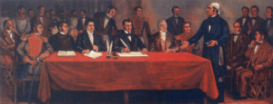
During the Mexican War of Independence, Chilpancingo was very important. Many people from the city helped the fighters who wanted Mexico to be free. In 1813, a special meeting called the Congress of Chilpancingo took place here. Leaders like José María Morelos y Pavón met to plan for Mexico's independence.
Later, in 1853, Chilpancingo became the temporary capital of the state. This happened because of a sickness in the old capital, Tixtla. The city also became the capital again in 1870 for a short time.
During the Mexican Revolution (around the 1910s), Chilpancingo was a key location for battles. A famous leader named Emiliano Zapata fought and won against government forces here. His army took control of the town in 1914.
In 1960, students from the Autonomous University of Guerrero started protests. They wanted more freedom for their college and less control from the state government. These protests grew and involved many people in the city. On April 27, 2009, an earthquake with a strength of 5.6 happened near Chilpancingo.
Geography
Climate
Chilpancingo has a tropical savanna climate. This means it's usually warm all year round. Even though it's high up in the mountains, temperatures often reach the upper 20s °C (80s °F).
| Climate data for Chilpancingo de los Bravo (1951–2010) | |||||||||||||
|---|---|---|---|---|---|---|---|---|---|---|---|---|---|
| Month | Jan | Feb | Mar | Apr | May | Jun | Jul | Aug | Sep | Oct | Nov | Dec | Year |
| Record high °C (°F) | 35.0 (95.0) |
35.0 (95.0) |
37.0 (98.6) |
38.2 (100.8) |
39.0 (102.2) |
37.5 (99.5) |
37.0 (98.6) |
35.5 (95.9) |
34.0 (93.2) |
34.0 (93.2) |
34.0 (93.2) |
32.5 (90.5) |
39.0 (102.2) |
| Mean daily maximum °C (°F) | 27.9 (82.2) |
28.6 (83.5) |
30.2 (86.4) |
31.2 (88.2) |
31.3 (88.3) |
28.9 (84.0) |
27.9 (82.2) |
28.3 (82.9) |
27.6 (81.7) |
28.1 (82.6) |
28.3 (82.9) |
27.7 (81.9) |
28.8 (83.8) |
| Daily mean °C (°F) | 19.5 (67.1) |
20.2 (68.4) |
21.5 (70.7) |
23.1 (73.6) |
24.0 (75.2) |
23.2 (73.8) |
22.5 (72.5) |
22.7 (72.9) |
22.3 (72.1) |
22.1 (71.8) |
21.2 (70.2) |
19.8 (67.6) |
21.8 (71.2) |
| Mean daily minimum °C (°F) | 11.1 (52.0) |
11.8 (53.2) |
12.9 (55.2) |
14.9 (58.8) |
16.6 (61.9) |
17.5 (63.5) |
17.0 (62.6) |
17.0 (62.6) |
16.9 (62.4) |
16.0 (60.8) |
14.0 (57.2) |
11.9 (53.4) |
14.8 (58.6) |
| Record low °C (°F) | 2.0 (35.6) |
2.0 (35.6) |
1.5 (34.7) |
9.0 (48.2) |
8.5 (47.3) |
10.5 (50.9) |
11.0 (51.8) |
12.0 (53.6) |
10.0 (50.0) |
9.0 (48.2) |
5.5 (41.9) |
4.0 (39.2) |
1.5 (34.7) |
| Average precipitation mm (inches) | 17.8 (0.70) |
3.1 (0.12) |
2.8 (0.11) |
17.2 (0.68) |
63.1 (2.48) |
162.4 (6.39) |
191.1 (7.52) |
152.7 (6.01) |
165.8 (6.53) |
78.1 (3.07) |
16.9 (0.67) |
2.8 (0.11) |
873.8 (34.40) |
| Average precipitation days (≥ 0.1 mm) | 1.4 | 0.9 | 0.6 | 1.9 | 6.6 | 16.1 | 21.1 | 19.1 | 18.2 | 9.1 | 2.0 | 0.8 | 97.8 |
| Average relative humidity (%) | 75 | 73 | 70 | 69 | 73 | 82 | 84 | 84 | 87 | 82 | 78 | 76 | 77 |
| Mean monthly sunshine hours | 213.9 | 211.9 | 232.5 | 195.0 | 176.7 | 147.0 | 164.3 | 170.5 | 135.0 | 179.8 | 198.0 | 201.5 | 2,226.1 |
| Source 1: Servicio Meteorológico Nacional | |||||||||||||
| Source 2: Deutscher Wetterdienst (sun and humidity 1941–1970) | |||||||||||||
Economy
The Autonomous University of Guerrero was started in Chilpancingo in 1869. It is still a very important part of the city's economy.
Chilpancingo makes processed foods and alcoholic drinks. It is also a market where people buy and sell:
- maize (corn)
- sugarcane
- bananas
- livestock (farm animals)
- lumber (wood)
Archaeology
Archaeology is the study of human history through digging up old sites and artifacts.
Pezuapan is an archaeological site right in Chilpancingo. It covers an area of about 4,000 square meters. The things found here date back to between 650 AD and 1150 AD.
Other important archaeological sites in the Guerrero area include:
Twin towns – sister cities
Chilpancingo has special friendships with other cities around the world. These are called "twin towns" or "sister cities."
 McAllen, United States
 Cavite City, Philippines
See also
 In Spanish: Chilpancingo de los Bravo para niños
 | Ernest Everett Just |
 | Mary Jackson |
 | Emmett Chappelle |
 | Marie Maynard Daly |


