
Tlaxcala (city) facts for kids
Quick facts for kids
Tlaxcala
|
|||
|---|---|---|---|
| Tlaxcala de Xicohténcatl | |||

Clockwise: Xicotencatl Theatre, Statue of Tlahuicole, City Hall and state government seat, a bell tower in Our Lady of the Assumption Cathedral, University Cultural Center of UATX, San José Parish, cityscape overview
|
|||
|
|||

Location of Tlaxcala within Tlaxcala
|
|||

Tlaxcala
Location in Mexico
|
|||
| Country | |||
| State | |||
| Municipality | Tlaxcala | ||
| Founded | October 3, 1525 | ||
| Municipal Status | 1813 | ||
| Elevation
(of seat)
|
2,239 m (7,346 ft) | ||
| Population
(2020)
|
|||
| • Total | 99,896 | ||
| Demonym(s) | Tlaxcalan | ||
| Time zone | UTC-6 (Central (US Central)) | ||
| • Summer (DST) | UTC-5 (Central) | ||
| Postal code (of seat) |
90000
|
||
| Area code(s) | 246 | ||
| Website | http://www.capitaltlaxcala.gob.mx/ | ||


Tlaxcala (UK: /tləˈskɑːlə, tlæˈ-/ TLƏ-skah-LƏ-,_-TLA--, US: /tlɑːˈ-/ TLAH--, Spanish: [tla(ɣ)sˈkala]), officially Tlaxcala de Xicohténcatl, is the capital city of the Mexican state of Tlaxcala. It is also the largest city in the state and the main town of its municipality.
Unlike many other cities, Tlaxcala did not exist before the Spanish arrived. It was created by the Spanish as a center for spreading Christianity and for governing the area after they conquered the Aztec Empire. The city was once planned to be a very important religious center, but its population later decreased.
Today, Tlaxcala still has many beautiful old buildings from the colonial period. These include a former Franciscan monastery. There are also newer public buildings like the Xicohtencatl Theatre.
Contents
- History of Tlaxcala
- Exploring Tlaxcala City
- Historic Buildings and Landmarks
- Capilla Real de Indias
- Casa de Piedra
- Former Franciscan Monastery
- Jorge Aguilar Bullring
- State Government Palace
- San José Parish Church
- Former Municipal Palace
- Former Legislative Palace
- Xicohtencatl Theatre
- Tlaxcala Museum of Art
- Culture Palace
- Stairway of the Heroes
- Plaza Xicohténcatl
- Tizatlán Open Chapel
- Chapel of the Well of the Miraculous Water
- San Esteban Temple
- Local Events and Celebrations
- Historic Buildings and Landmarks
- Tlaxcala Municipality
- Geography and Nature
- Images for kids
- Twin Towns and Sister Cities
- See also
History of Tlaxcala
The name Tlaxcala likely comes from a Nahuatl phrase meaning "place of corn bread." The old symbol for the Tlaxcala region shows two hills with hands making a tortilla.
Early History and Aztec Times
The area where Tlaxcala city now stands was not a major settlement in ancient times. It was ruled by four groups: Tepeticpac, Ocotelolco, Tizatlan, and Quiahuiztlan. These groups joined together in the 1300s to protect themselves from the Aztecs and other enemies.
In the 14th and 15th centuries, Tlaxcala was a very important place in Mesoamerica. It traded goods from the Gulf of Mexico all the way to the Pacific Ocean and even with Central America.
As the Aztec Empire grew, it conquered Tlaxcala's neighbors. However, the Aztecs left Tlaxcala alone so they could have special "flower wars." These were not wars to conquer, but to capture soldiers for religious sacrifices. This also meant Tlaxcala's trade was cut off by the Aztecs.
Spanish Arrival and Alliance
This situation changed when the Spanish arrived in the early 1500s. Hernán Cortés saw a chance to make allies. He teamed up with the Tlaxcalans against the Aztecs. Tlaxcala became a safe place for Cortés and his soldiers to attack from and to regroup after they were first driven out of Tenochtitlan (the Aztec capital).
Even though the Tlaxcalans were strong allies, they did not have one main capital city. After the Spanish conquest, the Europeans chose the current location for Tlaxcala city. They wanted a central place to control the Tlaxcalans and to spread Christianity. The city was likely founded in the spring of 1522.
Tlaxcala was one of the first places in the Americas to have a bishop and a diocese (a church district). However, the main church seat later moved to Puebla.
Colonial Period and Growth
When the Spanish arrived, the Tlaxcala area had many people. But diseases and other changes caused the local population to decrease a lot. The city started to be built in 1537 with the construction of the San Francisco monastery.
Tlaxcala became a key center for the Tlaxcalan people during the time of Spanish rule. Trade was important, and one special item traded here was the cochineal insect, used to make a valuable red dye.
Tlaxcala was promised certain rights because they helped the Spanish conquer the Aztecs. When some of these promises were not kept, the Tlaxcalans created a special document called the Lienzo de Tlaxcala. This document was a complaint sent to the Spanish king.
In 1813, Tlaxcala city officially became a municipality, which is like a local government area.
Modern Era Developments
After French forces left the city in 1867, Tlaxcalan soldiers helped Porfirio Díaz free other cities like Puebla and Mexico City.
In the late 1800s, a leader named Próspero Cahuantzi helped the city grow. He built public works like kiosks, streets, markets, bridges, and government buildings. The historic center got electric lights, the state government palace was updated, and the Xicohtencatl Theatre was built.
After the Mexican Revolution, the city recovered and started to grow again. By 1927, it had about 6,000 people. In the mid-1900s, public education improved, and more public works were done, giving the city the look it has today.
Exploring Tlaxcala City

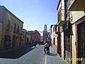
The city center is small and easy to explore. It is full of old colonial buildings painted in colors like burnt orange, salmon pink, and mustard yellow. Most of these buildings are around the main square, called the Plaza de la Constitución.
This square was created in 1524 when the Spanish planned the city. Its current name, Plaza de la Constitución, honors important Spanish and Mexican constitutions. In the middle of the square is the Santa Cruz Fountain, given to the city in 1646. There is also a kiosk built in the 1800s.
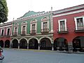
The Portal Hidalgo is on the east side of the main square. It was built in 1550 for shops and is still used for that today. The city hall moved here from its old location. Inside, you can find the city council chamber and other offices. There is also a cultural space called "La Tlaxcalteca" that sells local crafts, goods, and books about Tlaxcala.
Historic Buildings and Landmarks
Capilla Real de Indias
The Royal Indian Chapel was built in the 1500s for indigenous (native) nobles. After a fire and an earthquake, it was restored in 1984. Today, it houses the state's judicial branch.
Casa de Piedra
The "Stone House" is on the southwest corner of the main plaza. Built in the 1500s, it was a notary office and home. Its name comes from the strong gray sandstone used to build it.
Former Franciscan Monastery

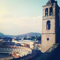
The old Franciscan monastery was built between 1537 and 1542. It is on a hill near the historic center. It was one of the first four monasteries built by the Franciscans in the Americas. The church still has its original wooden roof. The main part of the church has rare examples of Moorish art in the Americas.
The monastery has a large open area called an atrium and several chapels. The east atrium is famous because the first plays about Christianity were performed here in the Nahuatl language, starting in 1537. Today, this area is the Regional Museum of Tlaxcala. The museum has five rooms showing the state's history from ancient times to the 1800s, plus two rooms for special exhibits.
Jorge Aguilar Bullring
The Jorge Aguilar “El Ranchero” Bullring is next to the former monastery. It was one of the first bullrings in Tlaxcala, built in 1788. The current building, made of adobe and stone, dates from 1817. It is also used for the annual Tlaxcala Fair.
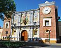
State Government Palace
The State Government Palace is an important building from the 1500s. It has three parts and is used for state government offices. Inside, you can see many murals by Desiderio Hernández Xochitiotzin that show the history of Tlaxcala.
San José Parish Church

The San José parish church was built in the 1700s in the Baroque style. It has orange walls with bright blue Talavera ceramic tiles. The front of the church is decorated with mortar work. The interior is in a Neoclassical style, but some older Baroque altars remain.
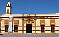
Former Municipal Palace
This building was constructed in the mid-1500s for the leaders of the four Tlaxcala groups to meet. It has two levels with arches. The main entrance has three arches with carvings. Inside, the main staircase has carvings of Xicohtencatl Axayacatzin and the four Tlaxcalan leaders from when the Spanish arrived.
Former Legislative Palace
This 19th-century building now houses the state's Secretary of Tourism. It was the site of the state's legislature from 1901 to 1982.
Xicohtencatl Theatre

The Xicohtencatl Theatre was built in 1873. It was remodeled after the Mexican Revolution. The building has a sandstone front in a Neoclassical style. Inside, the ceiling has a large Art Nouveau painting by John Fulton showing the Muses and Tlaxcala landscapes.
Tlaxcala Museum of Art

The Tlaxcala Museum of Art opened in 2004. It is in a 19th-century building that was once a hospital and then a jail. The museum has six main rooms for permanent exhibits and five for temporary ones.
Culture Palace
This building, started in 1939, was first a school. Later, it became part of the Universidad Autónoma de Tlaxcala, and since 1991, it has housed the Tlaxcala Cultural Institute.
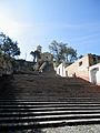
Stairway of the Heroes
.jpg)
This stairway is named after Mexican heroes. It has busts (sculptures of heads and shoulders) of important figures like Miguel Hidalgo and Emiliano Zapata.
Plaza Xicohténcatl

This plaza was created in the late 1900s for a weekend arts and crafts market. A pedestrian street, Calzada de San Francisco, leads from here up to the former monastery.
Tizatlán Open Chapel
The Tizatlán Open Chapel was built in the 1500s on top of an old pyramid platform. This building appears in the Tlaxcala Codex from 1550. There are still parts of murals showing scenes like the baptism of Jesus. Next to it is the Tizatlán archaeological site with ancient columns and altars.
Chapel of the Well of the Miraculous Water
This small chapel is at a fresh water spring. It was built between 1892 and 1896. Inside, there are murals with Bible scenes related to water. People traditionally buy red pottery ducks here as a sign of devotion or for healing.
San Esteban Temple
The San Esteban Temple was built in the 1900s in a Neoclassical style. Its open area serves as a cemetery. Inside, there is a mural showing the baptism of the four indigenous lords of Tlaxcala from the 1500s.
Local Events and Celebrations
Tlaxcala Carnival
The city celebrates Carnival starting the Friday before Ash Wednesday. It begins with burning a figure to represent "bad humor." The next day, the carnival queen is chosen. The main parade with floats happens on Tuesday. There are also dance contests and traditional dance performances.
Feria de Todos Santos
The Feria de Todos Santos is an important event that showcases the state's agriculture, handcrafts, and industry. It also includes concerts, art exhibits, dance, and regional food.
Tlaxcala Municipality

The city of Tlaxcala is the main governing center for itself and fifteen other communities. This area covers about 41.61 square kilometres (16.07 square miles). It is located in the southern part of the state, where most of the people live.
The local government is led by a municipal president, a "síndico" (a legal representative), and seven "regidors" (council members).
The municipality has a very low level of poverty. There are many homes, with 23,035 residences as of 2010[update].
Important communities outside the main city include Ocotlán, San Estebán Tizatlán, and Santa Maria Acuitlapilco.
Sanctuary of Our Lady of Ocotlán
The Sanctuary of Our Lady of Ocotlán is a beautiful church. It was finished in 1854 and became a minor basilica in 1957. The church is built in the Tlaxcalan Baroque style, known for using tile and red brick. The front of the church looks like a large altar and is topped with a seashell design.
Geography and Nature
.jpg)
Tlaxcala city is located in the central Mexican highlands, about 2,239 metres (7,346 feet) above sea level. From here, you can see the famous Popocatépetl and Iztaccíhuatl volcanoes in the distance. The highest points in the municipality are El Cerro Ostol at 2,460 metres (8,070 feet) and El Cerro Tepepan at 2,320 metres (7,610 feet).
Rivers and Water
The main river in the municipality is the Zahuapan. Other rivers include the Huizcalotla, Negros, Tlacuetla, and Lixcatlat. There are also parts of the old lake of Acuitlapilco. Fresh water comes from a spring in Acuitlapilco and a stream in Tepehitec that flows during the rainy season.
Plants and Animals
The higher areas of the municipality have forests of pine, holm oak, and white cedar trees. The middle elevations have mostly bushes and small trees. Flat areas have plants that can handle dry conditions, like agave, nopal cactus, and grasses.
Because the city has grown, there are only small wild animals left in the municipality. These include rabbits, squirrels, and opossums, along with some birds and reptiles.
Climate
The climate in Tlaxcala is temperate, meaning it's mild. It is semi-moist, with most of the rain falling in the summer. The average high temperature is about 24.3 °C (75.7 °F), and the average low is about 7.2 °C (45.0 °F).
| Month | Jan | Feb | Mar | Apr | May | Jun | Jul | Aug | Sep | Oct | Nov | Dec | Year |
|---|---|---|---|---|---|---|---|---|---|---|---|---|---|
| Record high °C (°F) | 28.4 (83.1) |
31.0 (87.8) |
35.0 (95.0) |
34.0 (93.2) |
39.2 (102.6) |
34.0 (93.2) |
30.0 (86.0) |
31.0 (87.8) |
31.0 (87.8) |
36.5 (97.7) |
30.1 (86.2) |
30.0 (86.0) |
39.2 (102.6) |
| Mean daily maximum °C (°F) | 22.1 (71.8) |
23.5 (74.3) |
25.9 (78.6) |
27.3 (81.1) |
27.5 (81.5) |
25.4 (77.7) |
24.5 (76.1) |
24.7 (76.5) |
23.9 (75.0) |
24.3 (75.7) |
23.5 (74.3) |
22.3 (72.1) |
24.6 (76.3) |
| Daily mean °C (°F) | 12.5 (54.5) |
13.6 (56.5) |
15.8 (60.4) |
17.7 (63.9) |
18.6 (65.5) |
18.2 (64.8) |
17.3 (63.1) |
17.5 (63.5) |
17.3 (63.1) |
16.5 (61.7) |
14.5 (58.1) |
13.0 (55.4) |
16.0 (60.8) |
| Mean daily minimum °C (°F) | 2.9 (37.2) |
3.7 (38.7) |
5.8 (42.4) |
8.0 (46.4) |
9.8 (49.6) |
11.1 (52.0) |
10.2 (50.4) |
10.3 (50.5) |
10.6 (51.1) |
8.7 (47.7) |
5.4 (41.7) |
3.6 (38.5) |
7.5 (45.5) |
| Record low °C (°F) | −5.0 (23.0) |
−4.0 (24.8) |
−1.9 (28.6) |
0.0 (32.0) |
2.5 (36.5) |
3.0 (37.4) |
4.0 (39.2) |
2.4 (36.3) |
−0.5 (31.1) |
−0.3 (31.5) |
−4.5 (23.9) |
−7.4 (18.7) |
−7.4 (18.7) |
| Average precipitation mm (inches) | 8.7 (0.34) |
7.4 (0.29) |
10.4 (0.41) |
31.1 (1.22) |
74.8 (2.94) |
158.1 (6.22) |
156.4 (6.16) |
162.2 (6.39) |
140.0 (5.51) |
68.0 (2.68) |
11.1 (0.44) |
6.3 (0.25) |
834.5 (32.85) |
| Average precipitation days (≥ 0.1 mm) | 1.4 | 1.5 | 2.5 | 6.6 | 12.2 | 17.4 | 19.0 | 19.0 | 16.8 | 9.0 | 2.5 | 1.2 | 109.1 |
| Average relative humidity (%) | 70 | 67 | 66 | 67 | 69 | 75 | 77 | 77 | 79 | 74 | 70 | 73 | 72 |
| Mean monthly sunshine hours | 218 | 220 | 251 | 218 | 196 | 154 | 167 | 174 | 176 | 221 | 226 | 216 | 2,437 |
| Source 1: Servicio Meteorológico National (humidity 1981–2000) | |||||||||||||
| Source 2: Deutscher Wetterdienst (sun, 1961–1990) | |||||||||||||
Images for kids
-
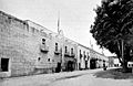
City Hall complex was set the Royal House
-

Pre Hispanic ceramics at the Regional Museum
-
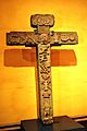
Atrial cross from the early colonial period
-
City Hall complex
-
-
-
Museum of the Memory
-
The bullring "Jorge "Rancher" Aguilar" and church
-
Del Buen Vecino Church
-
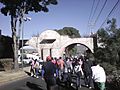
Aqueduct
-
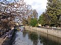
Zahuapan River, channeled by the Spanish
-

-

Statue of Tlahuicole
-
Capilla de los Indios, present-day state of Tlaxcala supreme court building
-
Tlaxcala Museum of Art


.jpg)


Twin Towns and Sister Cities
- Salé (Morocco), 1997.
- Medellín (Spain), 1997.
- Munébrega (Spain), 1997.
- Pamplona (Spain), 2005.
- Incheon (South Korea), 2007.
- Saltillo (Mexico), 2009.
- Villa de Álvarez (Mexico), 2010.
- Chilpancingo (Mexico), 2010.
- Ixtaczoquitlán (Mexico), 2012.
See also
 In Spanish: Tlaxcala de Xicohténcatl para niños
